New Jersey Route 284
| |||||||
|---|---|---|---|---|---|---|---|
|
NJ 284 highlighted in red | |||||||
| Route information | |||||||
| Maintained by NJDOT | |||||||
| Length: | 7.03 mi[1] (11.31 km) | ||||||
| Existed: | 1966 – present | ||||||
| Major junctions | |||||||
| South end: |
| ||||||
| North end: |
| ||||||
| Location | |||||||
| Counties: | Sussex | ||||||
| Highway system | |||||||
| |||||||

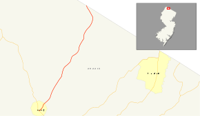
Route 284 is a 7.03-mile (11.31 km) state highway in New Jersey, United States, running from Route 23 in Sussex north to the New York state line in Wantage Township. New York State Route 284 continues north to U.S. Route 6 at Slate Hill, New York. The route is a connector to Unionville, and intersects with an old alignment of its original designation, Route 84. Route 284 was first a part of Route 8 in the 1920s, becoming Route 8N in 1927 and Route 84 in 1942 before being assigned Route 284 in 1966.
Route description
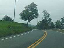
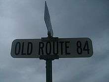
Route 284 begins at a signaled intersection in Sussex with NJ 23.[1] The route proceeds northward, intersecting with Sussex County Route 643 at less than a half-mile into the highway. Route 284 leaves the borough of Sussex and enters Wantage Township, intersecting with Layton Road, Janice Drive, and Possum River Road. Route 284 passes to the south of a lake, crosses over a branch of the Wallkill River and intersects with County Route 642 (Bassets Bridge Road). Just after the intersection with Route 642, the rural highway crosses over Quarryville Brook. At 5.41 miles (8.71 km), Route 284 intersects with an old routing of its original designation, NJ 84. The original alignment merges in with NJ 284 less than a mile later. After crossing the Wallkill River branch again and the Appalachian Trail, Route 284 leaves New Jersey for New York and becomes NY 284.[1]
History
.svg.png)
Route 8, one of the routes assigned before the 1927 renumbering, ran largely along the present Route 23 corridor, but at Sussex it turned north rather than continuing northwest through High Point State Park.[2][3] The section from Sussex north to the state line was taken over by the state in 1919. In the 1927 renumbering, the majority of Route 8 became Route 23.[4] The part north of Sussex was proposed to become part of Route 31, but that was instead moved to the present Route 94 corridor in the final version of the bill. As Route 8 north of Sussex was not assigned a number, the State Highway Commission appended a suffix of N (to distinguish it from new Route 8), forming Route 8N.[5] The connecting route in New York had been numbered New York State Route 8 to match New Jersey, but in the 1930 renumbering it became New York State Route 84, in order to free up the number 8 for a longer route. New Jersey renumbered its Route 8N to New Jersey Route 84 in March 1942 to match, in part to provide a single number for military caravans during World War II.[6]
The final renumbering was made in 1966, when Interstate 84 opened in New York. As the new I-84 was close to the older Route 84, Route 84 was renumbered in both New York and New Jersey to Route 284.[7]
Major intersections
The entire route is in Sussex County.
| Location | mi[1] | km | Destinations | Notes | |
|---|---|---|---|---|---|
| Sussex | 0.00 | 0.00 | |||
| Wantage Township | 7.03 | 11.31 | Continuation into New York | ||
| 1.000 mi = 1.609 km; 1.000 km = 0.621 mi | |||||
See also
 U.S. Roads portal
 New Jersey portal
- Interstate 84, the nearby route that changed the designation of NY 284
References
- 1 2 3 4 Route 284 "NJ 284 straight line diagram" Check
|url=value (help) (PDF). New Jersey Department of Transportation. 2007. Retrieved 2008-10-07. - ↑ Pennsylvania & New Jersey (Map). Cartography by Rand McNally. Tydol. 1926.
- ↑ Pennsylvania-New Jersey-Delaware-Maryland (Map). Cartography by Rand McNally. Tydol. 1927.
- ↑ Happy Motoring in New York (Map). Cartography by General Drafting Inc. Esso. 1936.
- ↑ Road Map of New York (Map). Cartography by Standard Oil Company. Socony. 1931.
- ↑ Road Numbers Changed, The New York Times, March 20, 1942
- ↑ New Jersey (Map). Cartography by American Oil Company. American Oil Company. 1968.
External links
| Wikimedia Commons has media related to New Jersey Route 284. |