Morrisville, Vermont
| Morrisville, Vermont | |
|---|---|
| Village | |
|
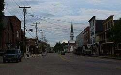
Downtown Morrisville, looking east along Main Street | |
 Morrisville, Vermont Location within the state of Vermont | |
| Coordinates: 44°33′35″N 72°35′50″W / 44.55972°N 72.59722°W | |
| Country | United States |
| State | Vermont |
| County | Lamoille |
| Area | |
| • Total | 1.9 sq mi (5.0 km2) |
| • Land | 1.9 sq mi (4.9 km2) |
| • Water | 0.0 sq mi (0.1 km2) |
| Elevation | 679 ft (207 m) |
| Population (2000) | |
| • Total | 2,009 |
| • Density | 1,069.7/sq mi (413.0/km2) |
| Time zone | Eastern (EST) (UTC-5) |
| • Summer (DST) | EDT (UTC-4) |
| ZIP codes | 05657, 05661 |
| Area code(s) | 802 Exchange: 888 |
| FIPS code | 50-46825[1] |
| GNIS feature ID | 1458547[2] |
Morrisville is a village in Morristown, Lamoille County, Vermont, United States. As of the 2000 census, the village population was 2,009. Morrisville has 2 country clubs, a hospital, a school featuring Greek architecture and an airport. The hospital and one of the country clubs are named after Alexander Copley, a philanthropist who donated much of the money for their construction. Copley also donated a large sum of money for the construction of the town's high school that is currently called Peoples Academy.
Geography
According to the United States Census Bureau, the village has a total area of 1.9 square miles (5.0 km²), of which, 1.9 square miles (4.9 km²) is land and 0.04 square mile (0.1 km²) (2.08%) is water.
Demographics
| Historical population | |||
|---|---|---|---|
| Census | Pop. | %± | |
| 1900 | 1,262 | — | |
| 1910 | 1,445 | 14.5% | |
| 1920 | 1,707 | 18.1% | |
| 1930 | 1,822 | 6.7% | |
| 1940 | 1,967 | 8.0% | |
| 1950 | 1,995 | 1.4% | |
| 1960 | 2,047 | 2.6% | |
| 1970 | 2,116 | 3.4% | |
| 1980 | 2,074 | −2.0% | |
| 1990 | 1,984 | −4.3% | |
| 2000 | 2,009 | 1.3% | |
| 2010 | 1,958 | −2.5% | |
| Est. 2015 | 2,040 | [3] | 4.2% |
Population of 1,977 persons in 2011. As of the census[1] of 2000, 860 households, and 459 families residing in the village. The population density was 1,069.7 people per square mile (412.6/km²). There were 909 housing units at an average density of 484.0/sq mi (186.7/km²). The racial makeup of the village was 96.96% White, 0.75% African American, 0.35% Native American, 0.90% Asian, 0.15% from other races, and 0.90% from two or more races. Hispanic or Latino of any race were 0.70% of the population.
There were 860 households out of which 26.6% had children under the age of 18 living with them, 35.8% were married couples living together, 14.4% had a female householder with no husband present, and 46.6% were non-families. 36.9% of all households were made up of individuals and 16.0% had someone living alone who was 65 years of age or older. The average household size was 2.19 and the average family size was 2.90.
In the village the population was spread out with 21.8% under the age of 18, 7.9% from 18 to 24, 25.3% from 25 to 44, 22.6% from 45 to 64, and 22.4% who were 65 years of age or older. The median age was 42 years. For every 100 females there were 81.3 males. For every 100 females age 18 and over, there were 73.4 males. The median income for a household in the village was $27,969, and the median income for a family was $37,697. Males had a median income of $26,542 versus $19,828 for females. The per capita income for the village was $15,446. About 9.9% of families and 14.1% of the population were below the poverty line, including 18.9% of those under age 18 and 11.2% of those age 65 or over.
Culture
The town of Morrisville has two weekly newspapers called "The News & Citizen" and "The Transcript".
The Vermont Wild of the Federal Hockey League played out of Morrisville's Green Mountain Arena, starting in the 2011-12 season, however, they suspended operations after approximately 2 weeks. The Wild were the first professional hockey team to play in Vermont.
Points of interest
- Morrisville historical society
- Morrisville Depot
Education
- Morrisville elementary school
- Peoples Academy Middle level & High School
- Bishop Marshall School - A private Catholic school accepting families of all faiths.
Notable people
- Chris Andrews (entrepreneur), IT pioneer
- Dewey K. Hickok, inventor of washing machine
- Maria von Trapp, inspiration for The Sound of Music; died in Morrisville (March 28, 1987)
Climate
This climatic region is typified by large seasonal temperature differences, with warm to hot (and often humid) summers and cold (sometimes severely cold) winters. According to the Köppen Climate Classification system, Morrisville has a humid continental climate, abbreviated "Dfb" on climate maps.[5]
References
- 1 2 "American FactFinder". United States Census Bureau. Retrieved 2008-01-31.
- ↑ "US Board on Geographic Names". United States Geological Survey. 2007-10-25. Retrieved 2008-01-31.
- ↑ "Annual Estimates of the Resident Population for Incorporated Places: April 1, 2010 to July 1, 2015". Retrieved July 2, 2016.
- ↑ "Census of Population and Housing". Census.gov. Retrieved June 4, 2015.
- ↑ Climate Summary for Morrisville, Vermont
Municipalities and communities of Lamoille County, Vermont, United States | ||
|---|---|---|
| Towns | 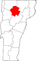 | |
| Villages | ||
| CDP | ||
| Unincorporated community | ||
Coordinates: 44°33′42″N 72°35′54″W / 44.56167°N 72.59833°W