Union Canal (Pennsylvania)
| Union Canal | |
|---|---|
|
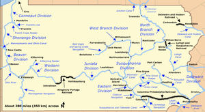
Map of historic Pennsylvania canals and connecting railroads | |
| Specifications | |
| Locks | 93 |
| Status | Abandoned except for historic interest |
| History | |
| Original owner | Union Canal Company |
| Principal engineer | Canvass White |
| Construction began | 1792 |
| Date completed | 1828 |
| Date closed | 1881 |
| Geography | |
| Start point | Reading |
| End point | Middletown |
| Branch(es) | Pine Grove Feeder |
| Connects to | Schuylkill Canal, Pennsylvania Canal (Eastern Division) |
The Union Canal was a towpath canal that existed in southeastern Pennsylvania in the United States during the 19th century. First proposed in 1690 to connect Philadelphia with the Susquehanna River, it ran approximately 82 mi from Middletown on the Susquehanna below Harrisburg to Reading on the Schuylkill River.
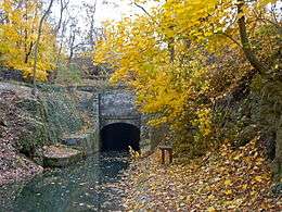
Construction began in 1792 during the George Washington Administration, but financial difficulties delayed its completion until 1828. Called the "Golden Link," it provided a critical early transportation route for shipping anthracite coal and lumber eastward to Philadelphia. Closed in the 1880s, remnants of the canal remain, most notably the Union Canal Tunnel, a hand-built engineering marvel that is the oldest existing transportation tunnel in the United States. The tunnel is listed in the National Register of Historic Places.
History
Proposal
A canal linking the Susquehanna and Delaware valleys in southeastern Pennsylvania was first proposed in 1690 by William Penn, the founder of the Pennsylvania Colony. Nearly a century passed before a route for the canal was surveyed by David Rittenhouse and William Smith between 1762 and 1770, the first canal ever surveyed in the U.S. Spurred by the 1791 discovery of anthracite in the upper Susquehanna Valley, the Pennsylvania General Assembly chartered two companies to undertake the project: the Schuylkill and Susquehanna Canal Company and the Delaware and Schuylkill Canal Company. At the time of the initial construction in the early 1790s, Philadelphia was involved in an intense rivalry with Baltimore for the supremacy as a shipping port. The canal was backed by Philadelphia businessmen as a means to divert commercial traffic from following the Susquehanna downriver to the Chesapeake Bay, its more natural destination.
From west to east, the route of the canal was to follow Swatara Creek upstream from Middletown to Quittapahilla Creek, which it then followed upstream past Lebanon and Myerstown to its headwaters. It then crossed overland to Clarks Run at the headwaters of Tulpehocken Creek, following Tulpehocken Creek downstream to Reading on the Schuylkill River. It was to follow the Schuylkill downriver to the Delaware River at Philadelphia.
Initial construction
Construction began in 1792 under the direction of William Weston, an experienced British canal engineer. The first shovel of earth was turned by President George Washington. By 1793, several miles of the canal were dug and five locks were built between Myerstown and Lebanon before financial difficulties caused the work to cease. In 1795 the Pennsylvania Legislature authorized a lottery to raise funds for the canal's construction. The largest canal lottery in U.S. history, it held 50 drawings over the next two decades, awarding $33 million in prize money, with only $270,000 reaching the canal companies.
By 1800, construction of the canal was pathetic and the largest oldest cities on the East Coast were experiencing an energy crisis—large stands of forest were no longer available near enough to the cities to easily bring in wood for fuel and charcoal production, and cities were beginning to import smokey sooty Bituminous Coal from England and Virginia]].[1] In 1811 the two canal companies were reorganized and merged as the Union Canal Company of Pennsylvania, and the project was given a new push by industrialists in New Jersey and Philadelphia. Innovative industrialist, Josiah White had discovered how to properly burn Anthracite circa 1808 and large easily mined deposits were found within 100 miles of Philadelphia over a decade earlier, but overland transportation by Mule train of bulk commodities was extremely costly. Local Rivers were rapids strewn and ran fast, not shallow and well behaved. By the end of the War of 1812 industrialists were getting desperate for fuels—mills and manufacturies were sometimes forced into going quiet for days. White and others pushed for canal funding, applied for rights to improve navigations on the Schuylkill, and eventually split off when he disagreed with other investors as the best way to proceed.
Construction resumed in 1821, probably in response to the successful improvements along the Lehigh designed by Joshiah White's and the Lehigh Navigation Company—which had began in 1818 to regularly deliver growing amounts of anthracite coal from Summit Hill, PA to the fuel starved coastal cities. One of the principal challenges was the construction of a 729-foot (222 m) tunnel through the ridge separating the headwaters of Quittapahilla Creek and Clarks Run. The drilling of the tunnel was by hand, using gunpowder to blast though argillaceous slate with veins of hard flinty limestone 80 feet (24 m) below the summit of the ridge. The progress of the tunnel was approximately 15 ft (4.5 m) per week, requiring over two years to complete. Another engineering difficulty was the lack of a sufficient continual supply of water at the summit level, a task that was compounded by leakage and required an elaborate pumping mechanism.
Although the initial design called for the construction of a canal from the Susquehanna to the Delaware, the 1825 opening of the rival Schuylkill Navigation from Reading to Philadelphia prompted the Union Canal Company to focus solely on the Middletown-Reading portion of the canal, which when connected would complete the longer conveyance west to the Susquehanna.
The canal was completed in 1828 under the direction of Canvass White, the preeminent canal engineer of the day. Upon its completion it was 8-1/2 ft (2.6 m) wide and had 93 locks. In 1832 a 22-mile (35 km) branch canal was constructed northward from the water works along the Swatara Creek to Pine Grove. The branch canal served as feeder for the summit level as well as allowing the transport of anthracite from the mountains, which became the principal revenue source for the canal operation.
Railroad
The charter of the canal company allowed it to build lateral railroad lines from the canal to reach coal mines. It built a 3.5-mile (5.6 km) line from the end of the branch canal to Lorberry Junction in 1830, which was operated by horse power. This connected it to the Lorberry Creek Railroad and brought coal traffic to the canal. In 1844, the track was leased to the Swatara Railroad, which extensively refurbished the right-of-way and began to operate it by steam locomotive in about 1850.[2] [3]
Operation and expansion

By the 1840s the narrow size of the canal locks prevented the passage of the larger barges that were adopted for use on the Pennsylvania Main Line and Schuylkill Navigation. The existing width restricted barges to 25 short tons (23 t). From 1841 to 1858, under the direction of chief engineer Loammi Baldwin, Jr., the canal was widened to 17 ft (5.2 m) to allow the passage of the larger boats carrying 75 short tons (68 t) to 80 short tons (73 t). In the process of the rebuilding, the tunnel through the summit ridge was shortened to 600 ft (180 m). The widening of the canal allowed for a brief period of prosperity in the late 1850s and early 1860s.
In June 1862 a flood on Swatara Creek damaged the western portion of the canal, completely destroying the Pine Grove feeder upon which the canal company depended for revenue. The flood prompted costly repairs that were compounded with continual water supply problems. The connecting railroad was leased to the Philadelphia and Reading Railroad on July 26, 1862, and sold outright in January 1866.[2] The completion of the Lebanon Valley Railroad in 1857 from Reading to Harrisburg cut into the canal revenues, forcing its closure in 1881.
Preservation
|
Union Canal Tunnel | |
|
South entrance | |
  | |
| Nearest city | Lebanon, Pennsylvania |
|---|---|
| Coordinates | 40°21′01″N 76°27′13″W / 40.35028°N 76.45361°W |
| Built | 1826 |
| Architect | Canvass White, John B. Ives |
| NRHP Reference # | 74001792[4] |
| Significant dates | |
| Added to NRHP | October 1, 1974 |
| Designated PHMC | March 01, 1948 and April 01, 1950[5] |
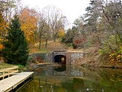
In April 1950, the Union Canal Tunnel was purchased by the Lebanon County Historical Society. The tunnel was placed on the National Register of Historic Places on October 1, 1974. It was designated a National Historic Civil Engineering Landmark in 1970. On April 19, 1994, the tunnel was designated a National Historic Landmark by the Secretary of the Interior Bruce Babbitt. The tunnel is open to visitors in the Union Canal Tunnel Park.
A restored portion of the canal along Tulpehocken Creek is maintained by the Berks County Parks System at the Union Canal Towpath Park in Wyomissing west of Reading. This portion contains several restored locks along a towpath now used as a recreational trail. A portion of the canal along Swatara Creek is also preserved at Swatara State Park where there are remains of 7 locks, a towpath bridge, major sections of the towpath, and three dams are still visible in Swatara State Park. The canal was never rebuilt because the railroad soon went into operation on the opposite bank of the Swatara Creek.[6]
Points of interest
| Feature | Coordinates | Description |
|---|---|---|
| Reading | 40°20′08″N 75°55′37″W / 40.33556°N 75.92694°W[7] | City at the eastern terminus |
| Pine Grove | 40°32′54″N 76°23′05″W / 40.54833°N 76.38472°W[8] | Borough at the northern terminus of the feeder canal |
| Lebanon | 40°20′27″N 76°24′41″W / 40.34083°N 76.41139°W[9] | City near the midpoint of the canal |
| Middletown | 40°11′59″N 76°43′52″W / 40.19972°N 76.73111°W[10] | Borough at the western terminus |
Notes
See also
- Allegheny Portage Railroad
- Delaware and Hudson Canal
- Delaware Canal, aka later: Pennsylvania Canal (Delaware Division)
- List of canals in the United States
- Lehigh Canal
- Pennsylvania Canal System
- Pennsylvania Canal, aka later: Pennsylvania Canal (Eastern Division)
- Pennsylvania Canal (North Branch Division)
- Pennsylvania Canal (Susquehanna Division)
- Pennsylvania Canal (West Branch Division)
- IPennsylvania Canal Guard Lock and Feeder Dam, Raystown Branch
- Pennsylvania Canal Tunnel
- Pennsylvania Canal and Limestone Run Aqueduct
References
- Bartholomew, Ann M.; Metz, Lance E.; Kneis, Michael (1989). DELAWARE and LEHIGH CANALS, 158 pages (First ed.). Oak Printing Company, Bethlehem, Pennsylvania: Center for Canal History and Technology, Hugh Moore Historical Park and Museum, Inc., Easton, Pennsylvania. ISBN 0930973097. LCCN 89-25150.[11]
- ↑ Bartholomew, Ann M.; Metz, Lance E.; Kneis, Michael (1989). DELAWARE and LEHIGH CANALS, 158 pages (First ed.). Oak Printing Company, Bethlehem, Pennsylvania: Center for Canal History and Technology, Hugh Moore Historical Park and Museum, Inc., Easton, Pennsylvania. pp. 3–7. ISBN 0930973097. LCCN 89-25150.
- 1 2 Taber, Thomas T., III (1987). Railroads of Pennsylvania Encyclopedia and Atlas. Thomas T. Taber III. ISBN 0-9603398-5-X.
- ↑ "History of Pine Grove" (PDF). Retrieved 2006-10-25.
- ↑ National Park Service (2007-01-23). "National Register Information System". National Register of Historic Places. National Park Service.
- ↑ "PHMC Historical Markers". Historical Marker Database. Pennsylvania Historical & Museum Commission. Retrieved December 20, 2013.
- ↑ http://dcnr.state.pa.us/stateparks/findapark/swatara/index.htm
- ↑ "Reading". Geographic Names Information System. United States Geological Survey. August 2, 1979. Retrieved March 21, 2009.
- ↑ "Pine Grove". Geographic Names Information System. United States Geological Survey. August 2, 1979. Retrieved March 21, 2009.
- ↑ "Lebanon". Geographic Names Information System. United States Geological Survey. August 2, 1979. Retrieved March 21, 2009.
- ↑ "Middletown". Geographic Names Information System. United States Geological Survey. August 2, 1979. Retrieved March 21, 2009.
- ↑ Bartholomew, DELAWARE and LEHIGH CANALS, by page listed.
External links
- Middletown Pa Dauphin County history: Union Canal History
- Lebanon County Historical Society: Union Canal Tunnel
- Lebanon, PA Union Canal Tunnel Park Photos
- Swatara State Park
- Pennsylvania Canal Society
- American Canal Society
- National Canal Museum
- Historic American Engineering Record (HAER) No. PA-66, "Union Canal Locks, Bernville, Berks County, PA", 32 photos, 11 data pages, 2 photo caption pages
Coordinates: 40°21′04″N 76°27′57″W / 40.35111°N 76.46583°W
| Topics |   | |
|---|---|---|
| Lists by county |
| |
| Lists by city | ||
| Other lists | ||
| ||