Allegheny Portage Railroad
|
Allegheny Portage Railroad | |
|
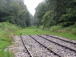
Incline 6 Trail and Recreated Tracks | |
  | |
| Location | Blair and Cambria counties, Pennsylvania, United States |
|---|---|
| Nearest city | Altoona, Pennsylvania |
| Coordinates | 40°27′15″N 78°32′25″W / 40.45417°N 78.54028°WCoordinates: 40°27′15″N 78°32′25″W / 40.45417°N 78.54028°W |
| Area | 1,296 acres (524 ha) |
| Built | 1831-1834 |
| Architectural style | Wood, Stone, Wrought Iron |
| Visitation | 118,931[1] (2009) |
| Website | Allegheny Portage Railroad National Historic Site |
| MPS | Allegheny Portage Railroad MPS |
| NRHP Reference # | 66000648[2] |
| Significant dates | |
| Designated NHL | December 29, 1962[3] |
| Designated PHMC | April 01, 1947[4] |

The Allegheny Portage Railroad was the first railroad constructed through the Allegheny Mountains in central Pennsylvania, United States; it operated from 1834 to 1854 as the first transportation infrastructure through the gaps of the Allegheny that connected the mid-west to the eastern seaboard across the barrier range of the Allegheny Front. Authorized as part of the Main Line of Public Works legislation in 1824, it was a series of 10 inclines connecting to a branch of the Pennsylvania Canal at either end, approximately 36 miles (58 km) long overall, and had five inclines on either side of the drainage divide running athwart the ridge line from Blair Gap through along the kinked saddle at the summit into Cresson, PA. The Portage Railroad utilized cleverly designed wheeled barges to ride a narrow-gauge rail track with steam-powered stationary engines lifting the vehicles. Except for peak moments of a severe storm, it was an all-weather, all-seasons operation. Along with the rest of the Main Works, it cut transport time from Philadelphia to the Ohio River from weeks to just 3–5 days. The roadbed of the railroad did not incline monotonically upwards, but rose in relatively long, saw-toothed stretches of slightly-sloped flat terrain suitable to animal powered towing, alternating with steep Cable railway inclined planes using static steam engine powered windlasses, similar to mechanisms of modern ski lifts.
It connected two canal 'divisions' of the Main Line of Public Works of the Pennsylvania Canal System, from Johnstown on the west through the relative flats to Hollidaysburg on the east, thus allowing continuous barge traffic between the Ohio and the Susquehanna rivers. Considered a technological marvel in its day, it played a critical role in opening the interior of the United States beyond the Appalachian Mountains to settlement and commerce. It included the first railroad tunnel in the United States, the Staple Bend Tunnel, and its inauguration was marked with great fanfare.
Today, the remains of the railroad are preserved within the Allegheny Portage Railroad National Historic Site operated by the National Park Service. The site was established on 1,296 acres (524 ha) in 1964 and is about 12 miles (19.3 km) west of Altoona, in Blair and Cambria counties.[5]
The Samuel Lemon House, a tavern located alongside the railroad near Cresson that was a popular stop for railroad passengers, has been converted into a historical museum by the National Park Service. The park service also operates a visitor center with interpretive exhibits near the Lemon House.
The Staple Bend Tunnel is preserved in a separate unit of the historic site 4 miles (6.4 km) east of Johnstown.
A skew arch bridge, a masterwork of cut stone construction, is another feature of the site.
History
Construction of the railroad began in 1831 and took three years to complete. The project was financed by the State of Pennsylvania as a means to compete with the Erie Canal in New York and the Chesapeake and Ohio Canal and Baltimore and Ohio Railroad in Maryland. The work was done largely through private contractors. The railroad used ten cable inclined planes, five on either side of the summit of the Allegheny Ridge. The vertical ascent from Johnstown was 1,172 feet (357 m). The vertical ascent from Hollidaysburg was 1,399 feet (426 m). The barges were drawn by horses along level sections, which included a tunnel 900 feet (274 m) long as well as a viaduct over the Little Conemaugh River upstream from Johnstown. A typical voyage took between six and seven hours. The entire Main Line system connecting Pittsburgh and Philadelphia was 400 miles (644 km) long. Charles Dickens wrote a contemporary account of travel on the railroad in Chapter 10 of his American Notes.[6]
In 1854 the portage railroad was rendered obsolete by construction of a locomotive railroad over the Alleghenies by the Pennsylvania Railroad, a private company. Construction on the New Portage Railroad, a $2.14 million realignment to bypass the inclines, continued despite this, opening in 1856. On July 31, 1857, the Pennsylvania Railroad bought the portage railroad from the state, abandoning most and using the rest as local branches. The graded roadbeds of the descending section east of the Gallitzin Tunnel was re-railed with standard gauge freight tracks and reopened as a freight bypass line in 1904. Pennsylvania Railroad successor Conrail abandoned this line to Hollidaysburg, PA and most of the branch trackage along the Juniata in 1981 and removed the rails.
-

Skew bridge at the National Historic Site
-

Exterior of Engine House 6 Exhibit Building
-

Interior of Engine House 6 Exhibit Building
-

Inside the Lemon House
-

Inside the Lemon House
-

Exterior of the Lemon House
-

Incline looking from the Engine house.
-

The skew arch bridge is 60.4 feet (18.4 m) long on the south elevation, 54.9 feet (16.7 m)long on the north elevation, and 22.2 feet (6.8 m)high.

See also
References
- ↑ "NPS Annual Recreation Visits Report". National Park Service.
- ↑ National Park Service (2006-03-15). "National Register Information System". National Register of Historic Places. National Park Service.
- ↑ "Allegheny Portage Railroad of the Pennsylvania Canal". National Historic Landmark summary listing. National Park Service. Archived from the original on October 7, 2012. Retrieved 2008-07-01.
- ↑ "PHMC Historical Markers". Historical Marker Database. Pennsylvania Historical & Museum Commission. Retrieved December 10, 2013.
- ↑ Allegheny Portage Railroad National Historic Site Boundary Revision Act (Public Law 107-369). Accessed 2009-10-21.
- ↑ Dickens, Charles. American notes for general circulation. ISBN 978-0-7607-6892-1.
Bibliography
- Mahlon J. Baumgardner and Floyd G. Hoenstine; The Allegheny Old Portage Railroad 1834-1854: Building Operation and travel between Hollidaysburg and Johnstown Pennsylvania
- Harley J. McKee, Introduction to Early American Masonry: Stone, Brick, Mortar, and Plaster
External links
| Wikimedia Commons has media related to Allegheny Portage Railroad. |
- Historic American Buildings Survey (HABS) No. PA-1232, "Skew Arch Bridge, Spanning Incline No. 6", 3 photos, 5 measured drawings, 1 photo caption page
- HABS No. PA-1233, "Staple Bend Tunnel", 2 photos, 2 measured drawings, 1 photo caption page
- Historic American Engineering Record (HAER) No. PA-239, "Skew Arch Bridge, Spanning Incline No. 6", 3 photos, 3 data pages, 1 photo caption page
- HAER No. PA-240, "Staple Bend Tunnel", 2 photos, 3 data pages, 1 photo caption page
- HAER No. PA-483, "Bens Creek Culvert", 5 photos, 1 color transparency, 11 data pages, 1 photo caption page
- National Park Service: Allegheny Portage Railroad National Historic Site
- Allegheny Portage Railroad: Developing Transportation Technology
- Map of the Route
- Allegheny Portage Railroad: Developing Transportation Technology, a National Park Service Teaching with Historic Places (TwHP) lesson plan
- The short film Allegheny Portage Railroad (1993) is available for free download at the Internet Archive
| Topics |   | |
|---|---|---|
| Lists by county |
| |
| Lists by city | ||
| Other lists | ||
| ||