Territorial evolution of Colorado
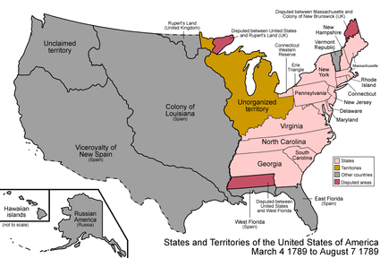
An enlargeable map of the United States after the Treaty of Paris in 1789
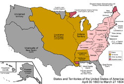
An enlargeable map of the United States after the Louisiana Purchase in 1803

An enlargeable map of the United States after the Adams-Onís Treaty took effect in 1821
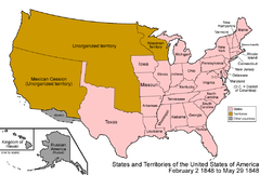
An enlargeable map of the United States after the Treaty of Guadalupe Hidalgo in 1848
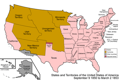
An enlargeable map of the United States after the Compromise of 1850

An enlargeable map of the United States after the Kansas-Nebraska Act in 1854

An enlargeable map of the United States after the Colorado Organic Act in 1861
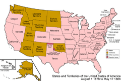
An enlargeable map of the United States after Colorado Statehood in 1876
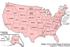
An enlargeable map of the United States as it has been since 1959
The following chronology traces the territorial evolution of the U.S. State of Colorado.
Timeline
- Historical territorial claims of Spain in the present State of Colorado:
- Nueva Vizcaya, 1562-1821
- Santa Fé de Nuevo Méjico, 1598-1821
- Treaty of Córdoba of 1821
- Historical territorial claims of France in the present State of Colorado:
- Louisiane, 1682–1764
- Historical territorial claims of Spain in the present State of Colorado:
- Luisiana, 1764-1803
- Third Treaty of San Ildefonso of 1800
- Luisiana, 1764-1803
- Historical territorial claims of France in the present State of Colorado:
- Louisiane, 1803
- Vente de la Louisiane of 1803
- Louisiane, 1803
- Historical territorial claims of Mexico in the present State of Colorado:
- Santa Fé de Nuevo México, 1821-1848
- Treaty of Guadalupe Hidalgo of 1848
- Santa Fé de Nuevo México, 1821-1848
- Historical territorial claims of the Republic of Texas in the present State of Colorado:
- Disputed territory between the Arkansas River and the Rio Grande, 1836-1845
- Texas Annexation of 1845
- Disputed territory between the Arkansas River and the Rio Grande, 1836-1845
- Historical political divisions of the United States in the present State of Colorado:
- Unorganized territory created by the Louisiana Purchase, 1803-1804
- District of Louisiana, 1804-1805
- Territory of Louisiana, 1805-1812
- Territory of Missouri, 1812-1821
- Adams-Onís Treaty of 1819
- Unorganized territory previously the western portion of the Missouri Territory, 1821-1854
- Disputed territory created by the Texas Annexation, 1845-1850
- Unorganized territory created by the Treaty of Guadalupe Hidalgo, 1848-1850
- State of Deseret (extralegal), 1849-1850
- Territory of New Mexico, 1850-1912
- Territory of Utah, 1850-1896
- Territory of Kansas, 1854-1861
- Territory of Nebraska, 1854-1867
- Territory of Jefferson (extralegal), 1859-1861
- Unorganized territory previously the western portion of the Kansas Territory, 1861
- Territory of Colorado, 1861-1876[1]
- State of Colorado since August 1, 1876[2][3]
See also
 Territorial evolution of Arizona
 Territorial evolution of Kansas
 Territorial evolution of Nebraska
 Territorial evolution of New Mexico
 Territorial evolution of Oklahoma
 Territorial evolution of Utah
 Territorial evolution of Wyoming
References
- ↑ Thirty-sixth United States Congress (February 28, 1861). "An Act to provide a temporary Government for the Territory of Colorado" (cgi-bin). Retrieved June 5, 2009.
- ↑ Forty-third United States Congress (March 3, 1875). "An Act to Enable the People of Colorado to Form a Constitution and State Government, and for the Admission of the Said State into the Union on an Equal Footing with the Original States". Archived from the original (PDF) on January 5, 2009. Retrieved June 4, 2009.
- ↑ Ulysses S. Grant (August 1, 1876). "By the President of the United States of America, A Proclamation Admitting the State of Colorado to the Union" (HTML). Retrieved June 4, 2009.
External links

This article is issued from Wikipedia - version of the 9/12/2016. The text is available under the Creative Commons Attribution/Share Alike but additional terms may apply for the media files.