Territorial evolution of Arizona
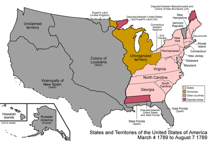
An enlargeable map of the United States after the Treaty of Paris in 1789
The following timeline traces the territorial evolution of the U.S. State of Arizona.
Timeline
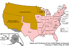
An enlargeable map of the United States after the Treaty of Guadalupe Hidalgo in 1848
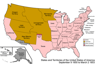
An enlargeable map of the United States after the Compromise of 1850
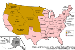
An enlargeable map of the United States after the Gadsden Purchase in 1853
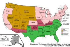
An enlargeable map of the United States after the Arizona Organic Act in 1863
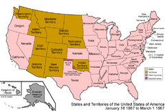
An enlargeable map of the United States after territorial transfer in 1867

An enlargeable map of the United States after Arizona Statehood in 1912
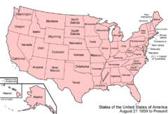
An enlargeable map of the United States as it has been since 1959
- Historical territorial claims of Spain in the present State of Arizona:
- Nueva Vizcaya, 1562-1821
- Santa Fé de Nuevo Méjico, 1598-1821
- Sonora y Sinaloa, 1732-1821
- Treaty of Córdoba of 1821
- Historical territorial claims of Mexico in the present State of Arizona:
- Santa Fé de Nuevo México, 1821-1848
- Sonora y Sinaloa (Estado de Occidente), 1824-1830
- Sonora since 1830
- Treaty of Guadalupe Hidalgo of 1848
- Gadsden Purchase of 1853
- Historical political divisions of the United States in the present State of Arizona:
- Unorganized territory created by the Treaty of Guadalupe Hidalgo, 1848-1850
- State of Deseret (extralegal), 1849-1850
- Territory of New Mexico, 1850-1912
- Gadsden Purchase of 1853
- American Civil War, 1861-1865
- Arizona Territory (CSA), 1861-1865
- Territory of Arizona, 1863-1912[1]
- North-western corner of the Arizona Territory is transferred to the State of Nevada, 1867
- State of Arizona since February 14, 1912
- Mexican Boundary Exchanges: In 1927 under the Banco Convention of 1905, the U.S. acquired two bancos from Mexico at the Colorado River border with Arizona. Farmers Banco, covering 583.4 acres (2.361 km2), a part of the Cocopah Indian Reservation at 32°37′27″N 114°46′45″W / 32.62417°N 114.77917°W, was ceded to the U.S. with controversy.[2] Fain Banco (259 acres (1.05 km2)) at 32°31′32″N 114°47′28″W / 32.52556°N 114.79111°W also became U.S. soil.
See also
 Territorial evolution of California
 Territorial evolution of Colorado
 Territorial evolution of Nevada
 Territorial evolution of New Mexico
 Territorial evolution of Utah
References
- ↑ Thirty-seventh United States Congress (February 24, 1863). "An Act to provide a temporary Government for the Territory of Arizona, and for other Purposes" (cgi-bin). Retrieved June 5, 2009.
- ↑ Decisions of the Department of the Interior in cases relating to the public lands: 1927-1954. United States. Department of the Interior. Washington. For sale by the Supt. of Docs., U.S. Govt. Print. Off. pp. 25, 337. Retrieved 2013-07-25.
External links
This article is issued from Wikipedia - version of the 12/16/2014. The text is available under the Creative Commons Attribution/Share Alike but additional terms may apply for the media files.