Stow, Massachusetts
| Stow, Massachusetts | ||
|---|---|---|
| Town | ||
|
Town center of Stow | ||
| ||
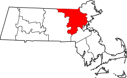
 Location in Middlesex County in Massachusetts | ||
| Coordinates: 42°26′13″N 71°30′22″W / 42.43694°N 71.50611°WCoordinates: 42°26′13″N 71°30′22″W / 42.43694°N 71.50611°W | ||
| Country | United States | |
| State | Massachusetts | |
| County | Middlesex | |
| Settled | c. 1660 | |
| Established | 1669 | |
| Incorporated | May 16, 1683 | |
| Government | ||
| • Type | Open town meeting | |
| Area | ||
| • Total | 18.1 sq mi (46.9 km2) | |
| • Land | 17.6 sq mi (45.6 km2) | |
| • Water | 0.5 sq mi (1.2 km2) | |
| Elevation | 231 ft (70 m) | |
| Population (2010) | ||
| • Total | 6,590 | |
| • Density | 374.4/sq mi (144.6/km2) | |
| Time zone | Eastern (UTC-5) | |
| • Summer (DST) | Eastern (UTC-4) | |
| ZIP code | 01775 | |
| Area code(s) | 351 / 978 | |
| FIPS code | 25-68050 | |
| GNIS feature ID | 0618236 | |
| Website | www.stow-ma.gov | |

Stow is a town in Middlesex County, Massachusetts, United States. The town is located 21 miles west of Boston, in the MetroWest region of Massachusetts. The population was 6,590 at the 2010 census.
History
Stow was first settled c. 1660 by Matthew Boon and John Kettell.[1] Coming from Gloucester and Charlestown, Massachusetts, these two men settled the land of the Tantamous (Jethro) Native Americans, called "Pompocitticut". Boon settled by a large body of water (later bearing his name: Lake Boon), upon a hill (also bearing his name: Boon Hill), with a vast tract of land surrounding him. It is said that he traded all this for a single jackknife. He lived on what is now known as Barton Road. A monument bearing his name is located on the plot of land he formerly resided on.
John Kettell took up residence in a portion of land in the southwestern corner of Stow, where the flatness helped with farming and its proximity to the Lancaster Garrison House (in present-day Bolton, owned by Reverend Joseph Rowlandson) house proved vital in later years. John, who brought his wife, Elizabeth Allen of Salem, Massachusetts, and three children: Elizabeth, Mary, Samuel, and James (the only one born in Stow in 1665), proceeded to trade with the natives and farm the land, though very little is known for fact.
Both families were involved in King Philip's War in 1676. Boon sent his family to the Sudbury Garrison House, then proceeded to return home with one of his sons and a neighbor. All three were killed. Little, if anything, is known about the remaining Boon family, but they did survive the initial attack.
John Kettell sent his family to the Lancaster Garrison, which was also attacked and burned. The natives took twenty captives, including Mary Rowlandson (a well-known captive, the wife of Rev. Rowlandson who wrote narratives of her captivity), Mrs. Rowlandson’s sister, Mrs. Elizabeth Kettell (John Kettell's wife), and some children. All twenty were ransomed by John Hoar of Concord for £20 after several months of the native life style. The Kettell family, once reunited, moved back to Salem, Massachusetts after selling their farm.
Stow was officially incorporated in 1683.
Geography
According to the United States Census Bureau, the town has a total area of 18.1 square miles (47 km2), of which 17.6 square miles (46 km2) is land and 0.5 square miles (1.3 km2) (2.60%) is water. It is located in eastern/central Massachusetts.
Stow borders the towns of Harvard, Boxborough, Acton, Maynard, Sudbury, Hudson, and Bolton.
Villages
The village of Gleasondale is in both Hudson and Stow.
Demographics
| Historical population | ||
|---|---|---|
| Year | Pop. | ±% |
| 1850 | 1,455 | — |
| 1860 | 1,641 | +12.8% |
| 1870 | 1,813 | +10.5% |
| 1880 | 1,045 | −42.4% |
| 1890 | 903 | −13.6% |
| 1900 | 1,002 | +11.0% |
| 1910 | 1,115 | +11.3% |
| 1920 | 1,101 | −1.3% |
| 1930 | 1,142 | +3.7% |
| 1940 | 1,243 | +8.8% |
| 1950 | 1,700 | +36.8% |
| 1960 | 2,573 | +51.4% |
| 1970 | 3,984 | +54.8% |
| 1980 | 5,144 | +29.1% |
| 1990 | 5,328 | +3.6% |
| 2000 | 5,902 | +10.8% |
| 2010 | 6,590 | +11.7% |
| * = population estimate. Source: United States Census records and Population Estimates Program data.[2][3][4][5][6][7][8][9][10][11] | ||

As of the census[12] of 2010, there were 6,590 people, 2,429 households, and 1,902 families residing in the town. The population density was 374.4 people per square mile (144.5/km²). There were 2,526 housing units at an average density of 143.5 per square mile (55.4/km²). The racial makeup of the town was 93.6% White, 0.7% African American, 0.2% Native American, 3.3% Asian, 0.4% from other races, and 1.9% from two or more races. Hispanic or Latino of any race were 1.9% of the population.
There are 2,429 households, out of which 37.2% have children under the age of 18 living with them, 69.7% were married couples living together, 6.4% had a female householder with no husband present, and 21.7% were non-families. 17.4% of all households were made up of individuals and 7.6% had someone living alone who was 65 years of age or older. The average household size was 2.71 and the average family size was 3.10.
In the town the population was spread out with 28.2% under the age of 20, 25.2% from 20 to 44, 34.5% from 45 to 64, and 12.7% who were 65 years of age or older. The median age was 43.5 years. For every 100 females there were 103.1 males. For every 100 females age 18 and over, there were 93.7 males.
The median income for a household in the town was $115,714, and the median income for a family was $135,582. The per capita income for the town was $47,880. About 1.6% of families and 2.7% of the population were below the poverty line, including 0.9% of those under age 18 and 2.2% of those age 65 or over.
Points of interest
Golf
Stow may be best known for its numerous golf courses, having 4 courses and 81 total holes of golf in town. The best known of these is Stow Acres Country Club, the site of the 1995 US Amateur Public Links Championship. Numerous times it has been ranked among the best public courses in the state and boasts a top 50 pro shop for public pro shops nationally.
Apple orchards
Stow is also well known for its numerous apple orchards and is a popular weekend destination for families during apple picking season.
Notable residents or past residents
- Matthew Tobin Anderson, known as M. T. Anderson, an author primarily of picture books for children and novels for young adults
- Tom Barrasso, former NHL goaltender
- Dan Duquette, former general manager of the Montreal Expos and Boston Red Sox and current general manager with the Baltimore Orioles.
- Henry Gardner, first Receiver-General/State Treasurer of Massachusetts from 1774 until his death in 1782. His grandson Henry J. Gardner served as Governor from 1855 to 1858.
- Grace Metalious, of "Peyton Place" fame. Her husband taught school in Stow after moving from Gilmanton, New Hampshire, where they had lived while she wrote her book; it is not clear whether she ever lived in Stow, as biographies state that they separated about the time the book was published.
- Lee H. Pappas, publisher of several well-known hi-tech publications, including A.N.A.L.O.G., PC Laptop, VideoGames & Computer Entertainment and TurboPlay
- George P. Shultz, former U.S. Secretary of State
- Kate Hogan, Massachusetts State Representative
- Pat Walrath, Former Massachusetts State Representative
- Greg Hill, radio show host: Hillman in the morning
Schools
Stow is a member of the Nashoba Regional School District, also serving the towns of Lancaster and Bolton. Stow is home to The Center School (PK-5), Hale Middle School (6-8), and Nashoba Regional High School (9-12).
Fire education
Stow is home to the Massachusetts Firefighting Academy. Future firefighters come here to train to become a firefighter at the minimum age of 18.
Airports
Minute Man Air Field (6B6), a privately owned, public-use airport, is located in Stow. Crow Island, an airfield for ultralights, is in Stow. The Collings Foundation is headquartered from a small grass airstrip at their museum that is also located in Stow.
 Stow Town Hall
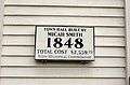 Stow Town Hall historical plaque
References
- ↑ Childs, Ethel B. (1983). (i)History of Stow(/i). Stow Historical Society. ISBN 978-0-9611058-1-5
- ↑ "TOTAL POPULATION (P1), 2010 Census Summary File 1". American FactFinder, All County Subdivisions within Massachusetts. United States Census Bureau. 2010.
- ↑ "Massachusetts by Place and County Subdivision - GCT-T1. Population Estimates". United States Census Bureau. Retrieved July 12, 2011.
- ↑ "1990 Census of Population, General Population Characteristics: Massachusetts" (PDF). US Census Bureau. December 1990. Table 76: General Characteristics of Persons, Households, and Families: 1990. 1990 CP-1-23. Retrieved July 12, 2011.
- ↑ "1980 Census of the Population, Number of Inhabitants: Massachusetts" (PDF). US Census Bureau. December 1981. Table 4. Populations of County Subdivisions: 1960 to 1980. PC80-1-A23. Retrieved July 12, 2011.
- ↑ "1950 Census of Population" (PDF). Bureau of the Census. 1952. Section 6, Pages 21-10 and 21-11, Massachusetts Table 6. Population of Counties by Minor Civil Divisions: 1930 to 1950. Retrieved July 12, 2011.
- ↑ "1920 Census of Population" (PDF). Bureau of the Census. Number of Inhabitants, by Counties and Minor Civil Divisions. Pages 21-5 through 21-7. Massachusetts Table 2. Population of Counties by Minor Civil Divisions: 1920, 1910, and 1920. Retrieved July 12, 2011.
- ↑ "1890 Census of the Population" (PDF). Department of the Interior, Census Office. Pages 179 through 182. Massachusetts Table 5. Population of States and Territories by Minor Civil Divisions: 1880 and 1890. Retrieved July 12, 2011.
- ↑ "1870 Census of the Population" (PDF). Department of the Interior, Census Office. 1872. Pages 217 through 220. Table IX. Population of Minor Civil Divisions, &c. Massachusetts. Retrieved July 12, 2011.
- ↑ "1860 Census" (PDF). Department of the Interior, Census Office. 1864. Pages 220 through 226. State of Massachusetts Table No. 3. Populations of Cities, Towns, &c. Retrieved July 12, 2011.
- ↑ "1850 Census" (PDF). Department of the Interior, Census Office. 1854. Pages 338 through 393. Populations of Cities, Towns, &c. Retrieved July 12, 2011.
- ↑ "American FactFinder". United States Census Bureau. Retrieved 2015-11-17.
External links
| Wikimedia Commons has media related to Stow, Massachusetts. |