Holliston, Massachusetts
| Holliston, Massachusetts | |||
|---|---|---|---|
| Town | |||
|
Holliston Town Hall on the east border of the town green | |||
| |||
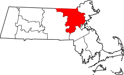
 Location in Middlesex County in Massachusetts | |||
| Coordinates: 42°11′00″N 71°25′30″W / 42.18333°N 71.42500°WCoordinates: 42°11′00″N 71°25′30″W / 42.18333°N 71.42500°W | |||
| Country | United States | ||
| State | Massachusetts | ||
| County | Middlesex | ||
| Settled | 1659 | ||
| Incorporated | 1724 | ||
| Government | |||
| • Type | Open town meeting | ||
| Area | |||
| • Total | 19.0 sq mi (49.3 km2) | ||
| • Land | 18.7 sq mi (48.5 km2) | ||
| • Water | 0.3 sq mi (0.9 km2) | ||
| Elevation | 188 ft (57 m) | ||
| Population (2010) | |||
| • Total | 13,547 | ||
| • Density | 710/sq mi (270/km2) | ||
| Time zone | Eastern (UTC-5) | ||
| • Summer (DST) | Eastern (UTC-4) | ||
| ZIP code | 01746 | ||
| Area code(s) | 508 / 774 | ||
| FIPS code | 25-30700 | ||
| GNIS feature ID | 0618225 | ||
| Website | http://www.townofholliston.us/ | ||


Holliston is a New England town in Middlesex County, Massachusetts, United States in the Greater Boston area. The population was 13,547 at the 2010 census.[1] It is part of the Massachusetts region, located due west of Boston, that is known as the MetroWest. Holliston is the only town in Middlesex County that borders both Norfolk and Worcester counties.
History


%2C_d._1901.jpg)
At the time of the earliest European settlements, where Holliston exists now was part of the territory of the Awassamog family of Natick (the first Nipmuc Praying Town), who also held authority over land near Waushakum Pond at Framingham and land near Annamasset at Mendon. In 1701, a large tract of land that included the west half of Holliston, eastern Milford and parts of Hopkinton and Ashland was given to the local Nipmucs in a land exchange with Sherborn. Their ownership of the tract was brief, as settlers purchased tracts of land there until all traces of Nipmuc presence disappeared. The Nipmuc village of Mucksquit (translation – “place of much grass”), located on the shore of Wennakeening (translation – “smile of the great spirit”) was near the site of the Morse family farm, today known as Lake Winthrop. The Morses, Sheffields, Marshalls and Bullards and many others followed Pout Lane (an old Native American foot-path, now partly modern day Rte 16 and Highland St., respectively) out to the new territory and settled along the path, thus forming a cluster of farms that would eventually become Holliston. John Eliot and Daniel Gookin (Christian missionaries) also followed the path in search of converts to Christianity and encouraged the Nipmucs to gather into villages, which made their task of finding them easier. Though not as famous as the Bay Path or the Old Connecticut Path, Pout Lane played a major role in the settlement of Holliston and other points southwest of Boston. Holliston, then part of Sherborn, was first settled by Europeans in 1659 by Massachusetts Bay Puritans. The town of Holliston was incorporated on December 3, 1724, by virtue of approval by the General Court petition requesting that "the western part of Sherborn be a Town." The name was taken in honor of Thomas Hollis of London, a benefactor of Harvard College. The first town meeting was held at the house of Timothy Leland on December 23, 1724, "at which five selectmen and all other required officers were chosen." The town has grown from a community of a few hundred residents setting aside ten pounds per year for public education to a community of over 13,000 with an annual budget of over $40 million including more than $23 million for a nationally recognized school system.[2]
In "Holliston" by Images of America and the Holliston Historical Society, it is written: An article in a local newspaper[3] in 1894 heralded the charms of Holliston as the quintessential New England village, which, the story said, sprang into existence solely due to the talent of its people. Perhaps this is so, for there was no great moment in history to mark the founding of this town. Holliston has become a reflection of the accomplishments of the inhabitants of this place for more than three hundred years, and although the town had to admit to no magnitude of greatness to rival Boston, Lexington, or Concord, Holliston did define itself as a home to heroes of the commonplace. The feature story of 1894 said:
"Many cities have sprung into existence because of their advantageous situations. The prosperity of Holliston is solely due to the genius of its people. A visit to such places stirs the blood, quickens the pulse and produces an enthusiastic desire to have a share in the developing good times. Massachusetts may be Whittier's land, and the region from Marblehead to Amesbury may be full of legendary and spectral armies, and witchdom, and Buddha knows what, but the imaginative and the poetical must submit to the rights of the commonplace. The commonplace is honeycombed with the uncommon heroisms of the patient, everyday existence that make up the life of such plucky towns as Holliston. These are the things the average man is most interested in. Average life is but a portfolio of views of struggles with the commonplaces of everyday existence" (Holliston 1997).
The town was once the largest producer of shoes in the United States.[4] Although many of the shoe factories have been lost by fires and other problems, the largest company, the Goodwill Shoe Company, still has remaining empty factories on Water Street, many of which are now used as artists' studios. Competition from overseas factories is largely to blame for the loss of the industry.
Holliston's Mudville neighborhood claims to be the location of the 1888 Ernest Lawrence Thayer poem, "Casey at the Bat", and maintains an ongoing rivalry with Stockton, California, which makes the same claim regarding the poem's setting.
The Legend of Balancing Rock

On the north side of Route 16 heading into Milford sits a large rock, some 20 ft (6.1 m) in length, 10 ft (3.0 m) in width, 6 ft (1.8 m) thick, and weighing easily over 5 tons (4.5 metric tons). The rock appears to be balanced precariously on an outcrop of granite ledge. On November 6, 1789, General George Washington led his entourage from Boston to New York via this route. He recalled in his diary the road in Holliston that would eventually be honored with his name, "an indifferent road, diversified by good and bad land, cultivated and in woods, some high barren, others low, wet and piney." Legend has it that, as they came across this "Balancing Rock," they took the opportunity to have some fun and tried their best to tip over the rock. It is said that the General himself, quite amused at the spectacle, added his muscle in an attempt to push the rock off its natural pedestal. Their efforts — and those of many others over the years — were to no avail as Balancing Rock still stands today. The rock is on the property of the Balancing Rock development, a community for "active" adults over the age of 55.[5]
Holliston today
Once populated by factories and farms up until the latter part of the nineteenth century, Holliston has now transformed itself into a bedroom community for Boston and the Route 128 and Route 495 technology belts. Holliston is known for its quaint Town Center with its Fiske's General Store, the Superette, numerous antique shops and boutiques, Carnegie public library, town hall, and white-steepled churches. Numerous white antique colonial, Greek revival, and Victorian homes with well-manicured lawns dot the landscape along Washington Street (Massachusetts Route 16), with Holliston Center and the Town Green wedged in between—a scene reminiscent of the distinctive New England character.
The average work commute for Holliston residents, however, is quite long. On average, people spend 32.25 minutes each day getting to work, which is significantly higher than the national average. Being a small town, Holliston does not have a public transit system that can be used by locals to get to and from work. Residents who want to take public transportation into Boston must drive to one of the commuter rail stations in Ashland, Natick, Framingham, or Franklin.
The town is the setting for the popular FEARnet series "Holliston"[6]
Geography
According to the United States Census Bureau, the town has a total area of 19.0 square miles (49 km2), of which 18.7 square miles (48 km2) is land and 0.3 square miles (0.78 km2) is water. Water covers 1.73% of the town's total area. The Charles River passes near the southern region of town.
It is located 21.6 mi (34.8 km) west of Boston and is within short driving distance of Interstate 495 and the Massachusetts Turnpike (part of Interstate 90). Massachusetts Route 16 and Massachusetts Route 126 pass through the town.
Historic districts

With a history spanning nearly three centuries, Holliston has many smaller divisions within its borders with names tied to a host of historic and cultural origins. Although the town is only served by one post-office today, several of its historic villages originated from previous post offices as well as train stops on the Boston and Albany Railroad's Milford line. Today the town retains two official historic districts, both of which contain smaller landmark areas of historic significance. There are several additional residential developments and other areas of Holliston which retain their own colloquial names, however at this time the following are the only areas officially recognized as historic by the town and the U.S. Geologic Survey.
- Braggville
- East Holliston
- Gooch Corners
- Metcalf
- Mudville
- Thomas Hollis Historic District
- Holliston Center
Adjacent towns
Holliston is located in eastern Massachusetts, bordered by:
- Sherborn on the east
- Millis on the south
- Medway on the west
- Milford on the west
- Hopkinton on the west
- Ashland on the north
Demographics
| Historical population | ||
|---|---|---|
| Year | Pop. | ±% |
| 1765 | 705 | — |
| 1776 | 909 | +28.9% |
| 1790 | 875 | −3.7% |
| 1800 | 783 | −10.5% |
| 1810 | 989 | +26.3% |
| 1820 | 1,024 | +3.5% |
| 1830 | 1,304 | +27.3% |
| 1840 | 1,782 | +36.7% |
| 1850 | 2,428 | +36.3% |
| 1860 | 3,339 | +37.5% |
| 1870 | 3,073 | −8.0% |
| 1880 | 2,098 | −31.7% |
| 1890 | 2,619 | +24.8% |
| 1900 | 2,598 | −0.8% |
| 1910 | 2,711 | +4.3% |
| 1920 | 2,707 | −0.1% |
| 1930 | 2,804 | +3.6% |
| 1940 | 3,000 | +7.0% |
| 1950 | 3,753 | +25.1% |
| 1960 | 6,222 | +65.8% |
| 1970 | 12,069 | +94.0% |
| 1980 | 12,622 | +4.6% |
| 1990 | 12,926 | +2.4% |
| 2000 | 13,801 | +6.8% |
| 2010 | 13,547 | −1.8% |
| * = population estimate.[7] Source: United States Census records and Population Estimates Program data.[8][9][10][11][12][13][14][15][16][17] | ||
As of the census[18] of 2000, there were 13,801 people, 4,795 households, and 3,842 families residing in the town. The population density was 737.8 people per square mile (284.8/km²). There were 4,868 housing units at an average density of 260.2 per square mile (100.5/km²). The racial makeup of the town was 96.7% White, 0.9% African American, 0.9% Native American, 1.2% Asian, 0.3% from other races, and 0.8% from two or more races. Hispanic or Latino of any race were 1.4% of the population. Ancestries of Holliston residents are reported to be Irish (29.4%), Italian (18.3%), English (17.8%), German (9.7%), French (5.6%), and Polish (5.6%).
There were 4,795 households out of which 44.2% had children under the age of 18 living with them, 70.2% were married couples living together, 7.5% had a female householder with no husband present, and 19.9% were non-families. 16.4% of all households were made up of individuals and 6.0% had someone living alone who was 65 years of age or older. The average household size was 2.87 and the average family size was 3.25.
In the town the population was spread out with 30.0% under the age of 18, 4.8% from 18 to 24, 29.4% from 25 to 44, 26.9% from 45 to 64, and 8.9% who were 65 years of age or older. The median age was 38.2 years. For every 100 females there were 96.3 males. For every 100 females age 18 and over, there were 91.8 males.
In 2000, the median income for a household in the town was $78,092, and the median income for a family was $84,878. Males had a median income of $48,473 versus $36,405 for females. The per capita income for the town was $32,116. As of the census of 2000, about 1.5% of families and 2.4% of the population were below the poverty line, including 2.9% of those under age 18 and 9.5% of those age 65 or over.
In 2009, 79% of Holliston residents age 25 and over held bachelor's degrees or higher and 35.8% held graduate or professional degrees.[19]
Government
Holliston retains its original open town meeting form of government, in which registered voters act as the town's legislature. The town's day-to-day affairs are overseen by an elected Board of Selectmen with a Town Administrator.
| Clerk of Courts: | Michael A. Sullivan |
|---|---|
| District Attorney: | Marian T. Ryan |
| Register of Deeds: | Maria C. Curtatone |
| Register of Probate: | Tara E. DeCristofaro |
| County Sheriff: | Peter J. Koutoujian |
| State government | |
| State Representative(s): | Carolyn Dykema (D) |
| State Senator(s): | Karen E. Spilka (D) |
| Governor's Councilor(s): | Robert L. Jubinville (D) |
| Federal government | |
| U.S. Representative(s): | Katherine Clark (D-5th District) |
| U.S. Senators: | Elizabeth Warren (D), Ed Markey (D) |
Education
The Town of Holliston has a public school system which serves students from kindergarten through twelfth grade. Schools in the district include two elementary schools, a middle school and a high school. Public schools include: Sam Placentino Elementary School, Fred W. Miller Elementary School, Robert H. Adams Middle School, and Holliston High School.
The Holliston public school system also maintains a Montessori and French Immersion program that students can enroll in upon entering kindergarten.
Environment
Within Holliston there are five registered Superfund sites. Three of these sites are still monitored by CERCLIS (Comprehensive Environmental Response, Compensation, and Liability Information System).[20]
| Name of site | Location | Status |
|---|---|---|
| Adams Street Property | 519 Adams Street | Archived |
| Wood Engineering | 29 Everett Road | Archived |
| Axton Cross Corp | 1 Cross Street | Non-NPL (National Priorities List) |
| Bird Property (Prentice Street Property) | 708 Prentice Street | Non-NPL |
| Photofabrication Engineering Inc. | 229 Lowland Street | Non-NPL |
An archived status indicates that the site has been cleaned, requires no further investigation, and poses little to no threat. A Non-NPL status indicates the sites are not considered to be the most hazardous by the EPA and are therefore not included in the NPL, but the clean-up of the site has not been completed. Non-NPL sites are still monitored by CERCLIS and are considered open or active sites. An NPL status indicates that the EPA considers the site to pose serious health and environmental risks. NPL sites are considered to be the most hazardous sites in the nation.
Axton Cross Corp
Established in 1967, “the site was an Industrial Chemical Distributor for the textile, paper, rubber, metals and plastics industries.”[22] In the early 1990s the company filed for bankruptcy and the facility closed. The site is 8.6 acres of developed and undeveloped land which consist of two buildings. The buildings are being considered for demolition.
According to the Mass DEP Axton Cross is considered to be a Disposal Site. The chemicals recorded by the Mass DEP were oil and other unknown hazardous materials. According to locals, “Axton-Cross polluted the property it owned and the land surrounding it and the wildlife with toxic chemicals.”[23] According to the EPA’s last inspection (08/08/1995), the water was not impaired, but the Ozone is considered to be a Non-Attainment Area. No further data was recorded.[24]
Bird Property (Prentice Street Property)
In 1966 a gravel mining permit for the property was granted to a Charles Bird. Mining of the land continued into the late 1970s. Through the late 1960s to early 1980’s the mined areas were filled with building debris and commercial solid waste. The property was also used for tire stockpiling.[25] The site is approximately 53 acres. The land is being considered for the construction of residential housing.[26]
Since then the Mass DEP and EPA have ordered remedial activities which included the removal of: potential contaminants, solid waste, construction debris, tires, and over 70 tons of impacted soils. The groundwater plume from the site contains low levels of a chemical called TCE. Due to the low and naturally declining levels (due to the removal of the source) the Mass DEP to conclude that no further water clean-up is required.[26] Other chemicals recorded by the Mass DEP were VOCs. According to the EPA’s inspection the Ozone is considered to be a Non-Attainment Area. No further data was recorded.[27]
Photofabrication Engineering Inc.
Founded in 1968, Photofabrication Engineering, Inc. (PEI) manufactures precision metal parts for computers and semiconductors. The company moved from Holliston to Milford, MA in 1984. The newer facility has helped PEI become an environmentally cleaner manufacturer.[28]
Chemicals recorded by the Mass DEP were chlorinated solvents, metals, and wastewater discharge. The Mass DEP considers the site to be in phase IV of V. In this phase a cleanup plan is implemented. According to the EPA’s inspection, the water was not impaired, but the Ozone is considered to be a Non-Attainment Area. No further data was recorded.[29]
Points of interest

- Apollo 14 Moon Tree, at the Holliston Police Department.
- Bogastow Brook Viaduct, also known as the Arch Bridge, off Woodland Street, named as one of the 1,000 places to visit in Massachusetts[30]
- Bullard Farm, the preserved homestead of the Bullard family, some of the first settlers of the town. Established in 1652, it served as the family's farm until 1916.
- Casey's Crossing, the town's first train depot, built in the 1840s. Presently a family restaurant and pub.
- Holliston Superette, a small neighborhood grocery and deli founded by Arthur and Nelli Guidi in 1960. It has been in business ever since and has been feature on Phantom Gourmet, as well as numerous other culinary shows.
- Holliston Grill, Formally Pete's Lunch (50 yrs) and the Black Horse Restaurant (25 yrs) offering full service breakfast and lunch in downtown Holliston, featured in the sitcom "Holliston" on Fearnet.com
- Fatima Shrine, a restful haven in a peaceful rustic setting, Fatima Shrine is an oasis for prayer, reflection, and meditation. The rosary walk at Fatima Shrine is believed to be the world's largest rosary.
- Fiske's General Store, founded in 1863, is the oldest retail business in town. Popular with the young and old, it's known for its catchphrase, "'most everything".
- First Congregational Church of Holliston, built on the site of Holliston's original meeting house, is the holding institution of the King James Bible donated by Thomas Hollis in 1724.
- Highland Farm, offering apple-picking in a picturesque orchard in the town's rolling hills
- Holliston Mill Artist Studios, once the former factory of the Goodwill Shoe Company, Bi-Annual Open House expositions of the varied artist occupants and their work
- Lake Winthrop is nearly 1 mile (1.6 km) in diameter and covers approximately 140 acres (57 ha). It was originally called "Dean Winthrop's Pond." and used as a boundary marker for his land. Dean was the son of John Winthrop. The town history states that the Nipmuck tribe, a clan of the Algonquian Indians, lived on the lake's southwestern shore in the village of Musquit near present-day Lake Grove Cemetery. The lake was then called Wennakeening, meaning “smile of the great spirit” or “pleasant smile”.[31] Today, Lake Winthrop offers fishing, kayaking, and swimming. In season 5 episode 4 of the sitcom "Cheers" Woody, Norm and Cliff go on a fishing outing to Lake Winthrop.
- Mount Hollis Lodge A.F. & A.M., founded in Holliston on February 14, 1865. This Masonic Lodge resides in a historic building that was once the Methodist Church in Holliston.
- National Police Scanner Museum
- Outpost Farm
- Upper Charles River Trail, a scenic, recreational path for bicycling, walking, cross-country skiing, roller-blading, and other non-motorized uses. When completed, the 20-mile (32 km) trail will connect Holliston to Ashland, Hopkinton, Milford, and Sherborn.
- Winter Street, A scenic road and is one of the longest and oldest roads in Holliston. The street begins at the height of the Thomas Hollis Historic District and stretches all the way to Ashland Street. Many of the oldest houses in Holliston can be found on Winter Street.
Golf courses
- Pinecrest Golf Club, 18-hole golf course
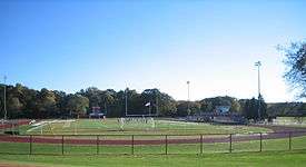
Parks and playing fields
Refer also to Town of Holliston, Parks and Recreation for information on use.
- Goodwill Park, playground for children, tennis courts, baseball and soccer fields
- Patoma Park, Stoddard Park's sister park offers woodland trails for hiking and recreational activities
- Pleasure Point, located on Lake Winthrop with a beach, picnic area, playground, and boat launch
- Stoddard Park, located on Lake Winthrop with a beach, picnic area, and recreational area (two youth baseball/softball diamonds)
- Weston Pond, multi-sport practice and soccer playing fields.
- Damigella Field, large baseball diamond and softball fields, part of the elementary and middle school complex.
- Kamitian Field, multi-sport artificial turf surface, part of the high school complex.
- Marshall Street Soccer Fields (Private, managed by Holliston Youth Soccer; permit-use only; closed after dark)
Annual events
Annual events include Memorial Day Parade and Veterans Lunch, Celebrate Holliston Day, Lions Carnival and Triathlon, Baseball Parade, A Taste of Holliston, Downtown Holiday Stroll, Summer Concerts at Goodwill Park, Historical Society Fairs, Council on Aging Fall Fair and an abundance of other fairs and festivals during the year.
Local organizations
- Holliston Business Association
- Holliston Cable Access TV-8 (Public-access television)
- Holliston Christian Preschool
- Holliston Conservation Associates
- Holliston Education Foundation
- Holliston Garden Club
- Holliston Historical Society
- Holliston Lions Club
- Holliston Newcomers Club
- Holliston Parent Teacher Student Association (PTSA)
- Holliston Pantry Shelf
- Holliston Referral Hub
- Holliston Senior Softball
- Holliston Sportsman Association
- Mudville Base Ball Club (Vintage Base Ball Association that plays by the Massachusetts Rules of 1858)
- Washington Street Players Theatrical group
- WHHB FM 99.9
- Mount Hollis Lodge - A.F & A.M
- Holliston Youth Lacrosse
- Holliston Youth Soccer
Notable people
- Arthur Judson Brown, clergyman, missionary, author
- Joseph Fish, first Major League Baseball player from Holliston, signed by the Boston Red Sox in 1957. Played in the Red Sox minor league system for 1 year. (http://www.baseball-reference.com/register/player.cgi?id=fish--001jos)
- Adam Green, director, writer and or actor for movies Hatchet and Frozen among other horror films
- Mike Grier, forward for Edmonton Oilers, Washington Capitols, Buffalo Sabres, San Jose Sharks hockey teams
- Michael Mantenuto, actor (Jack O'Callahan in Miracle)
- Greg Mauldin, center for NHL's Colorado Avalanche, played for the University of Massachusetts Minutemen
- Jo Dee Messina, popular country music singer
- Andrew Natsios, director, United States Agency for International Development
- Albert P. Rockwood, early Latter Day Saint leader
- John Sencio, national television personality - HGTV, NBC, MTV
- Ken Stone, UFC bantamweight fighter
- Mark Sweeney, first baseman, pinch hitter for San Diego Padres, Milwaukee Brewers, Colorado Rockies, Los Angeles Dodgers
- Kevin Systrom, founder of Instagram
- Jeff Taylor, founder of Monster.com, University of Massachusetts graduate
- Kara Wolters, professional basketball player and Olympic medal winner
- Lyndon Byers, retired NHL right-wing, currently a radio personality for the The Hill-man Morning Show
References
- ↑ "Profile of General Population and Housing Characteristics: 2010 Demographic Profile Data (DP-1): Holliston town, Middlesex County, Massachusetts". U.S. Census Bureau, American Factfinder. Retrieved April 6, 2012.
- ↑ Town of Holliston
- ↑ Holliston Historical Society
- ↑ Historic American Buildings Survey, 2005
- ↑ Balancing Rock 55 Community Website
- ↑ http://insidetv.ew.com/2012/01/09/holliston-fearnet-adam-green-dee-snider/
- ↑ Foster, F. Apthorp (ed.). Vital records of Holliston, Massachusetts to the Year 1850. Boston: Stanhope Press, F. H. Gilson Company. New England Historic Genealogical Society. p. 3.
- ↑ "TOTAL POPULATION (P1), 2010 Census Summary File 1". American FactFinder, All County Subdivisions within Massachusetts. United States Census Bureau. 2010.
- ↑ "Massachusetts by Place and County Subdivision - GCT-T1. Population Estimates". United States Census Bureau. Retrieved July 12, 2011.
- ↑ "1990 Census of Population, General Population Characteristics: Massachusetts" (PDF). US Census Bureau. December 1990. Table 76: General Characteristics of Persons, Households, and Families: 1990. 1990 CP-1-23. Retrieved July 12, 2011.
- ↑ "1980 Census of the Population, Number of Inhabitants: Massachusetts" (PDF). US Census Bureau. December 1981. Table 4. Populations of County Subdivisions: 1960 to 1980. PC80-1-A23. Retrieved July 12, 2011.
- ↑ "1950 Census of Population" (PDF). Bureau of the Census. 1952. Section 6, Pages 21-10 and 21-11, Massachusetts Table 6. Population of Counties by Minor Civil Divisions: 1930 to 1950. Retrieved July 12, 2011.
- ↑ "1920 Census of Population" (PDF). Bureau of the Census. Number of Inhabitants, by Counties and Minor Civil Divisions. Pages 21-5 through 21-7. Massachusetts Table 2. Population of Counties by Minor Civil Divisions: 1920, 1910, and 1920. Retrieved July 12, 2011.
- ↑ "1890 Census of the Population" (PDF). Department of the Interior, Census Office. Pages 179 through 182. Massachusetts Table 5. Population of States and Territories by Minor Civil Divisions: 1880 and 1890. Retrieved July 12, 2011.
- ↑ "1870 Census of the Population" (PDF). Department of the Interior, Census Office. 1872. Pages 217 through 220. Table IX. Population of Minor Civil Divisions, &c. Massachusetts. Retrieved July 12, 2011.
- ↑ "1860 Census" (PDF). Department of the Interior, Census Office. 1864. Pages 220 through 226. State of Massachusetts Table No. 3. Populations of Cities, Towns, &c. Retrieved July 12, 2011.
- ↑ "1850 Census" (PDF). Department of the Interior, Census Office. 1854. Pages 338 through 393. Populations of Cities, Towns, &c. Retrieved July 12, 2011.
- ↑ "American FactFinder". United States Census Bureau. Retrieved 2008-01-31.
- ↑ DP-2. Profile of Selected Social Characteristics: 2000
- 1 2 "Envirofacts Search Results | Envirofacts | US EPA". Retrieved 2015-06-27.
- ↑ "Holliston, MA Environmental Hazards | Homefacts". www.homefacts.com. Retrieved 2015-06-27.
|first1=missing|last1=in Authors list (help) - ↑ "Find New England Sites - AXTON CROSS CO". yosemite.epa.gov. Retrieved 2015-06-27.
- ↑ "Town vs Axton Cross Wednesday Night - Holliston Reporter". www.hollistonreporter.com. Retrieved 2015-06-27.
- ↑ "Detailed Facility Report | ECHO | US EPA". Retrieved 2015-06-27.
- ↑ "PHASE I ENVIRONMENTAL SITE ASSESSMENT REPORT" (PDF). Colar & Colantonio. May 2, 2005. Retrieved June 6, 2015.
- 1 2 "Green View Realty | Cedar Ridge Estates | Overview". www.greenviewrealty.com. Retrieved 2015-06-27.
- ↑ "Detailed Facility Report | ECHO | US EPA". Retrieved 2015-06-27.
- ↑ "About Photofabrication Engineering, Inc. – Metal Etching Experts". www.photofabrication.com. Retrieved 2015-06-27.
- ↑ "Detailed Facility Report | ECHO | US EPA". Retrieved 2015-06-27.
- ↑ "1,000 places to visit in Massachusetts". The Boston Globe. 26 July 2010.
- ↑ Holliston NetNews
Further reading
- Bragg, Ernest. The Shoe Industry of Holliston and Milford. 1st ed. Boston, 1950.
- 1871 Atlas of Massachusetts. by Wall & Gray. Map of Massachusetts. Map of Middlesex County.
- History of Middlesex County, Massachusetts, Volume 1 (A-H), Volume 2 (L-W) compiled by Samuel Adams Drake, published 1879-1880. 572 and 505 pages. Holliston article by Rev. George F. Walker, pages 470-483.
External links
| Wikimedia Commons has media related to Holliston, Massachusetts. |