Dunstable, Massachusetts
| Dunstable, Massachusetts | ||
|---|---|---|
| Town | ||
|
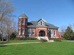
The town hall | ||
| ||
| Motto: "The Profit of the Field is for All" | ||
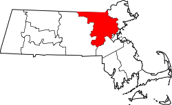
 Location in Middlesex County in Massachusetts | ||
| Coordinates: 42°40′30″N 71°29′00″W / 42.67500°N 71.48333°WCoordinates: 42°40′30″N 71°29′00″W / 42.67500°N 71.48333°W | ||
| Country | United States | |
| State | Massachusetts | |
| County | Middlesex | |
| Settled | 1656 | |
| Incorporated | 1673 | |
| Government | ||
| • Type | Open town meeting | |
| Area | ||
| • Total | 16.7 sq mi (43.4 km2) | |
| • Land | 16.6 sq mi (42.9 km2) | |
| • Water | 0.2 sq mi (0.5 km2) | |
| Elevation | 224 ft (68 m) | |
| Population (2010) | ||
| • Total | 3,179 | |
| • Density | 198.2/sq mi (76.7/km2) | |
| Time zone | Eastern (UTC-5) | |
| • Summer (DST) | Eastern (UTC-4) | |
| ZIP code | 01827 | |
| Area code(s) | 351 / 978 | |
| FIPS code | 25-17825 | |
| GNIS feature ID | 0618222 | |
| Website | http://www.dunstable-ma.gov/ | |

Dunstable (/ˈdʌnstəbəl/ DUN-stə-bəl) is a town in Middlesex County, Massachusetts, United States. The population was 3,179 at the 2010 census.
Etymology
Dunstable was named after its sister town Dunstable, England. There are several theories concerning its modern name. In one version, legend tells that the lawlessness of the time was personified in a thief called Dun. Wishing to capture Dun, the King stapled his ring to a post daring the robber to steal it. It was, and was subsequently traced to the house of the widow Dun. Her son, the robber, was taken and hanged to the final satisfaction that the new community bore his name.[1] Another theory is that it comes from the Anglo-Saxon for "the boundary post of Duna".[1][2] A third version is that the name is derived from Dunum, or Dun, a hill, and Staple, a marketplace.[3]
History

Dunstable was first settled in 1656 and was officially incorporated in 1673. It is likely named after the town of Dunstable in Bedfordshire, England, home of Edward Tyng, the town's first settler. The original township of Dunstable, granted in 1661, consisted of two hundred square miles, including the Massachusetts towns of Dunstable, Pepperell, Townsend and Tyngsborough, the New Hampshire towns of Hudson, Nashua and Hollis, and parts of other towns as well. Increases in population leading to subsections becoming independent towns and the delineation of the northern boundary of Massachusetts in 1740 placed the northern part of Dunstable (present day Nashua) in New Hampshire, so the southern part remains the Dunstable of today.
Today, Dunstable, in the face of urban sprawl, has held onto a largely rural character.
Geography
According to the United States Census Bureau, the town has a total area of 16.7 square miles (43 km2), of which 16.5 square miles (43 km2) is land and 0.2 square miles (0.52 km2) (1.13%) is water. Dunstable is bordered by Pepperell to the west, Groton to the south, Tyngsborough to the east, and Nashua and Hollis, New Hampshire, to the north.
Demographics
| Historical population | ||
|---|---|---|
| Year | Pop. | ±% |
| 1850 | 590 | — |
| 1860 | 487 | −17.5% |
| 1870 | 471 | −3.3% |
| 1880 | 453 | −3.8% |
| 1890 | 416 | −8.2% |
| 1900 | 427 | +2.6% |
| 1910 | 408 | −4.4% |
| 1920 | 353 | −13.5% |
| 1930 | 384 | +8.8% |
| 1940 | 447 | +16.4% |
| 1950 | 522 | +16.8% |
| 1960 | 824 | +57.9% |
| 1970 | 1,292 | +56.8% |
| 1980 | 1,671 | +29.3% |
| 1990 | 2,236 | +33.8% |
| 2000 | 2,829 | +26.5% |
| 2010 | 3,179 | +12.4% |
| * = population estimate. Source: United States Census records and Population Estimates Program data.[4][5][6][7][8][9][10][11][12][13] | ||
As of the census[14] of 2000, there were 2,826 people, 923 households, and 798 families residing in the town. The population density was 171.0 people per square mile (66.0/km²). There were 944 housing units at an average density of 57.0 per square mile (22.0/km²). The racial makeup of the town was 97.49% White, 0.11% African American, 0.04% Native American, 1.52% Asian, 0.07% from other races, and 0.78% from two or more races. Hispanic or Latino of any race were 0.53% of the population.
There were 923 households out of which 47.5% had children under the age of 18 living with them, 76.7% were married couples living together, 7.2% had a female householder with no husband present, and 13.5% were non-families. 10.3% of all households were made up of individuals and 3.7% had someone living alone who was 65 years of age or older. The average household size was 3.07 and the average family size was 3.31.
In the town the population was spread out with 31.1% under the age of 18, 4.4% from 18 to 24, 31.4% from 25 to 44, 26.2% from 45 to 64, and 6.8% who were 65 years of age or older. The median age was 37 years. For every 100 females there were 97.7 males. For every 100 females age 18 and over, there were 93.3 males.
The median income for a household in the town was $86,633, and the median income for a family was $92,270. Males had a median income of $61,425 versus $39,946 for females. The per capita income for the town was $30,608. About 2.1% of families and 1.9% of the population were below the poverty line, including 2.4% of those under age 18 and 2.1% of those age 65 or over.
Education
District schools
- Boutwell School
- Swallow Union Elementary School
- Florence Roche Elementary School
- Groton-Dunstable Regional Middle School
- Groton-Dunstable Regional High School
- Prescott Elementary School (Closed after the 2007-2008 school year due to budget cuts)[15]
Other public schools
- Greater Lowell Technical High School- Public Regional Technical High School in Tyngsborough, Massachusetts
Points of interest
- "The Little Red Schoolhouse" is a historical building located on route 113 near the Tyngsborough border. This school house originally came from Tyngsborough. Local students take field trips there to historically re-enact a school day. An annual Strawberry Festival is also held there. Boy Scout Troop 28 of Dunstable holds a Mother’s Day pancake breakfast there every year.
- The "Sarah R. S. Roby" Town Hall in located at 511 Main Street (Rt. 113) was built in 1909 and renovated in 2003. Most town offices are located here as well as meeting rooms for various meetings and events.
- The Town Commons across from the Dunstable Town Hall on Rt. 113 is the site of many town events including the Summer Fest Carnival sponsored by the Dunstable-Tyngsborough Lion's Club in June, the summer "Concerts on the Common" live performance series and the Grange Fair in August. This is also the site for the annual auto show in Dunstable.
- The Dunstable Evangelical Congregational Church (DECC) is located at 518 Main Street, adjacent to the Town Commons and directly across from Town Hall. While the congregation was established in that location in 1831, the current building dates from the early 1900s. Because it is the only church in town, it is often called simply "the Dunstable Church".
- The Dunstable Free Library is located at 588 Main Street. In addition to the collection of books, periodicals, movies, children’s activities and historic items (which include a collection of typewriters and misc. Girl Scouting materials), it is the site of many community activities as well as the site for town elections.
- Blanchard Hill is a 39-acre conservation area[16] and the site of a former ski resort.[17]
Notable residents
- Isaac Fletcher (1784–1842), United States Representative from Vermont
- Amos Kendall (1789–1869), United States Postmaster General during the administration of Andrew Jackson
- Amos Lawrence (1786–1852), merchant and philanthropist
- Samuel Parris (1653–1720), Puritan minister during the Salem witch trials
- Ellen Swallow Richards (1842–1911), chemist, first woman admitted to MIT
References
- 1 2 Adrian Room (ed.), Brewer's dictionary of Fame and Fable (1st ed.), ISBN 0-304-34869-4
- ↑ Sunday Times Travel, 6 January 2008, p. 46
- ↑ Genuki entry for Dunstable, Accessed 26_12_09
- ↑ "TOTAL POPULATION (P1), 2010 Census Summary File 1". American FactFinder, All County Subdivisions within Massachusetts. United States Census Bureau. 2010.
- ↑ "Massachusetts by Place and County Subdivision - GCT-T1. Population Estimates". United States Census Bureau. Retrieved July 12, 2011.
- ↑ "1990 Census of Population, General Population Characteristics: Massachusetts" (PDF). US Census Bureau. December 1990. Table 76: General Characteristics of Persons, Households, and Families: 1990. 1990 CP-1-23. Retrieved July 12, 2011.
- ↑ "1980 Census of the Population, Number of Inhabitants: Massachusetts" (PDF). US Census Bureau. December 1981. Table 4. Populations of County Subdivisions: 1960 to 1980. PC80-1-A23. Retrieved July 12, 2011.
- ↑ "1950 Census of Population" (PDF). Bureau of the Census. 1952. Section 6, Pages 21-10 and 21-11, Massachusetts Table 6. Population of Counties by Minor Civil Divisions: 1930 to 1950. Retrieved July 12, 2011.
- ↑ "1920 Census of Population" (PDF). Bureau of the Census. Number of Inhabitants, by Counties and Minor Civil Divisions. Pages 21-5 through 21-7. Massachusetts Table 2. Population of Counties by Minor Civil Divisions: 1920, 1910, and 1920. Retrieved July 12, 2011.
- ↑ "1890 Census of the Population" (PDF). Department of the Interior, Census Office. Pages 179 through 182. Massachusetts Table 5. Population of States and Territories by Minor Civil Divisions: 1880 and 1890. Retrieved July 12, 2011.
- ↑ "1870 Census of the Population" (PDF). Department of the Interior, Census Office. 1872. Pages 217 through 220. Table IX. Population of Minor Civil Divisions, &c. Massachusetts. Retrieved July 12, 2011.
- ↑ "1860 Census" (PDF). Department of the Interior, Census Office. 1864. Pages 220 through 226. State of Massachusetts Table No. 3. Populations of Cities, Towns, &c. Retrieved July 12, 2011.
- ↑ "1850 Census" (PDF). Department of the Interior, Census Office. 1854. Pages 338 through 393. Populations of Cities, Towns, &c. Retrieved July 12, 2011.
- ↑ "American FactFinder". United States Census Bureau. Retrieved 2008-01-31.
- ↑ "Prescott Home Page". Archived from the original on February 16, 2010.
- ↑ "LIST OF PARCELS IN DUNSTABLE" (PDF). Dunstable-Ma.gov. Retrieved 18 November 2014.
- ↑ "DUNSTABLE RECONNAISSANCE REPORT" (PDF). Mass.gov. Massachusetts Department of Conservation and Recreation. Retrieved 18 November 2014.
Further reading
- Nason, Elias and George Bailey Loring. A History of the Town of Dunstable, Massachusetts. A. Mudge: 1877.
- 1871 Atlas of Massachusetts. by Wall & Gray. Map of Massachusetts. Map of Middlesex County.
- History of Middlesex County, Massachusetts, Volume 1 (A-H), Volume 2 (L-W) compiled by Samuel Adams Drake, published 1879-1880. 572 and 505 pages. Dunstable article by Rev. Elias Nason in volume 1 pages 416-427.
External links
| Wikimedia Commons has media related to Dunstable, Massachusetts. |