Bolton, Massachusetts
| Bolton, Massachusetts | |||
|---|---|---|---|
| Town | |||
|
Sawyer House, Bolton Historical Society | |||
| |||
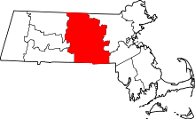
 Location in Worcester County and the state of Massachusetts. | |||
| Coordinates: 42°26′00″N 71°36′30″W / 42.43333°N 71.60833°WCoordinates: 42°26′00″N 71°36′30″W / 42.43333°N 71.60833°W | |||
| Country | United States | ||
| State | Massachusetts | ||
| County | Worcester | ||
| Settled | 1682 | ||
| Incorporated | 1738 | ||
| Government | |||
| • Type | Open town meeting | ||
| • Town Administrator | Donald (Don) Lowe[1] | ||
| • Board of Selectmen |
Stanley Wysocki Mark Sprague Larry Delaney | ||
| Area | |||
| • Total | 20.0 sq mi (51.8 km2) | ||
| • Land | 19.9 sq mi (51.6 km2) | ||
| • Water | 0.1 sq mi (0.2 km2) | ||
| Elevation | 387 ft (118 m) | ||
| Population (2010) | |||
| • Total | 4,897 | ||
| • Density | 240/sq mi (95/km2) | ||
| Time zone | Eastern (UTC-5) | ||
| • Summer (DST) | Eastern (UTC-4) | ||
| ZIP code | 01740 | ||
| Area code(s) | 351 / 978 | ||
| FIPS code | 25-06365 | ||
| GNIS feature ID | 0618357 | ||
| Website | www.townofbolton.com | ||


Bolton is a town in Worcester County, Massachusetts, United States. Bolton is in eastern Massachusetts, located 25 miles west-northwest of downtown Boston.The population was 4,897 at the 2010 census.
History
The town of Bolton was incorporated on June 24, 1738, following an influx of settlers. Town historian Esther Whitcomb, descendant of one of Bolton's earliest documented settlers, cites the recorded birth of a son, Hezekiah, to Josiah Whitcomb in 1681. By 1711, according to Whitcomb, more than 150 people were living on Bolton soil, despite a local history of Indian uprisings and one massacre. Many early houses were protected by flankers, and were designated as garrisons. Bolton's history is interesting because it is reflective of early settlement patterns in the central Massachusetts area, and the conflicts with King Philip (Metacom) and his Indian soldiers. The town was formerly part of the town of Lancaster, but seceded along the Still River, where the current boundary line still stands.[2]
In the 1920s Bolton was used as a setting and mentioned a number of times in H.P. Lovecraft's fiction: as a setting in his “Herbert West — Reanimator”, and also mentioned in his “The Rats in the Walls” and “The Colour out of Space”.
Geography
According to the United States Census Bureau, the town has a total area of 20.0 square miles (52 km2), of which 19.9 square miles (52 km2) is land and 0.1 square miles (0.26 km2), or 0.35%, is water.
Surrounding towns
Bolton is located in MetroWest, surrounded by several towns:
 |
Lancaster | Harvard | Boxborough | |
| |
Stow | |||
| ||||
| | ||||
| Clinton | Berlin | Hudson |
Demographics
| Historical population | ||
|---|---|---|
| Year | Pop. | ±% |
| 1850 | 1,263 | — |
| 1860 | 1,348 | +6.7% |
| 1870 | 1,014 | −24.8% |
| 1880 | 903 | −10.9% |
| 1890 | 827 | −8.4% |
| 1900 | 770 | −6.9% |
| 1910 | 764 | −0.8% |
| 1920 | 708 | −7.3% |
| 1930 | 764 | +7.9% |
| 1940 | 775 | +1.4% |
| 1950 | 956 | +23.4% |
| 1960 | 1,264 | +32.2% |
| 1970 | 1,905 | +50.7% |
| 1980 | 2,530 | +32.8% |
| 1990 | 3,134 | +23.9% |
| 2000 | 4,148 | +32.4% |
| 2010 | 4,897 | +18.1% |
| * = population estimate. Source: United States Census records and Population Estimates Program data.[3][4][5][6][7][8][9][10][11][12] | ||
As of the census[13] of 2000, there were 4,148 people, 1,424 households, and 1,201 families residing in the town. The population density was 208.1 inhabitants per square mile (80.3/km2). There were 1,476 housing units at an average density of 74.1 per square mile (28.6/km2). The racial makeup of the town was 97.76% White, 0.19% African American, 0.05% Native American, 1.30% Asian, 0.02% Pacific Islander, 0.19% from other races, and 0.48% from two or more races. Hispanic or Latino of any race were 0.80% of the population.
There were 1,424 households out of which 44.7% had children under the age of 18 living with them, 77.0% were married couples living together, 5.1% had a female householder with no husband present, and 15.6% were non-families. 11.2% of all households were made up of individuals and 3.1% had someone living alone who was 65 years of age or older. The average household size was 2.91 and the average family size was 3.18.
In the town the population was spread out with 30.4% under the age of 18, 3.3% from 18 to 24, 31.2% from 25 to 44, 28.8% from 45 to 64, and 6.2% who were 65 years of age or older. The median age was 38 years. For every 100 females there were 100.8 males. For every 100 females age 18 and over, there were 96.1 males.
The median income for a household in the town was $102,798, and the median income for a family was $108,967. Males had a median income of $79,167 versus $50,278 for females. The per capita income for the town was $53,195.[14] About 1.1% of families and 1.8% of the population were below the poverty line, including 1.5% of those under age 18 and 3.5% of those age 65 or over.
Government
| County-level state agency heads | |
|---|---|
| Clerk of Courts: | Dennis P. McManus (D) |
| District Attorney: | Joseph D. Early, Jr. (D) |
| Register of Deeds: | Anthony J. Vigliotti (D) |
| Register of Probate: | Stephanie K. Fattman (R) |
| County Sheriff: | Lew Evangelidis (R) |
| State government | |
| State Representative(s): | Kate Hogan (D) |
| State Senator(s): | Jennifer Flanagan (D) |
| Governor's Councilor(s): | Jen Caissie (R) |
| Federal government | |
| U.S. Representative(s): | Niki Tsongas (D) (3rd District), |
| U.S. Senators: | Elizabeth Warren (D), Ed Markey (D) |
Schools
Bolton is a member of the Nashoba Regional School District, also serving the towns of Lancaster and Stow. Bolton is home to Florence Sawyer School (PK-8) and Nashoba Regional High School.
Notable people
- Suzy Becker, author
- William C. Edes, chairman, Alaskan Engineering Commission
- Karen O'Connor, equestrian
- Bill Ezinicki, NHL hockey player, professional golfer, won three Stanley Cups with the Toronto Maple Leafs, inducted into PGA tour hall of fame New England Section in 1997
- Hal Gill, current NHL player for the Nashville Predators
- Frank L. McNamara, Jr., United States Attorney for the District of Massachusetts from 1987 to 1989
- William C. Sullivan, head of the Federal Bureau of Investigation's intelligence operations from 1961 to 1971
- J. Sterling Livingston, professor at the Harvard Business School from 1945 to 1974
- Philip J. Philbin (1898-1972), member of the United States House of Representatives from Massachusetts's 3rd district from 1943 to 1971
- William Ellery Leonard (1876-1944), poet and author, professor at the University of Wisconsin’s Dept. of English.
- Wilbert Robinson, Baseball Hall of Fame inductee[15]
- Frederick A. Sawyer (1822-1891), United States Senator from South Carolina
- Nathan Wilson, member of the United States House of Representatives from New York's 12th congressional district from 1808 to 1809
- Amos Nourse (1794–1877), United States Senator from Maine
- Samuel Stearns (1741-1809), astronomer and author.
References
- ↑ "New town administrator is fitting right in", Bolton Common, May 29, 2009.
- ↑ Whitcomb, Esther Kimmon (1988). About Bolton. Bowie, MD: Heritage Books, Inc. ISBN 1-55613-105-4.
- ↑ "TOTAL POPULATION (P1), 2010 Census Summary File 1". American FactFinder, All County Subdivisions within Massachusetts. United States Census Bureau. 2010.
- ↑ "Massachusetts by Place and County Subdivision - GCT-T1. Population Estimates". United States Census Bureau. Retrieved July 12, 2011.
- ↑ "1990 Census of Population, General Population Characteristics: Massachusetts" (PDF). US Census Bureau. December 1990. Table 76: General Characteristics of Persons, Households, and Families: 1990. 1990 CP-1-23. Retrieved July 12, 2011.
- ↑ "1980 Census of the Population, Number of Inhabitants: Massachusetts" (PDF). US Census Bureau. December 1981. Table 4. Populations of County Subdivisions: 1960 to 1980. PC80-1-A23. Retrieved July 12, 2011.
- ↑ "1950 Census of Population" (PDF). Bureau of the Census. 1952. Section 6, Pages 21-10 and 21-11, Massachusetts Table 6. Population of Counties by Minor Civil Divisions: 1930 to 1950. Retrieved July 12, 2011.
- ↑ "1920 Census of Population" (PDF). Bureau of the Census. Number of Inhabitants, by Counties and Minor Civil Divisions. Pages 21-5 through 21-7. Massachusetts Table 2. Population of Counties by Minor Civil Divisions: 1920, 1910, and 1920. Retrieved July 12, 2011.
- ↑ "1890 Census of the Population" (PDF). Department of the Interior, Census Office. Pages 179 through 182. Massachusetts Table 5. Population of States and Territories by Minor Civil Divisions: 1880 and 1890. Retrieved July 12, 2011.
- ↑ "1870 Census of the Population" (PDF). Department of the Interior, Census Office. 1872. Pages 217 through 220. Table IX. Population of Minor Civil Divisions, &c. Massachusetts. Retrieved July 12, 2011.
- ↑ "1860 Census" (PDF). Department of the Interior, Census Office. 1864. Pages 220 through 226. State of Massachusetts Table No. 3. Populations of Cities, Towns, &c. Retrieved July 12, 2011.
- ↑ "1850 Census" (PDF). Department of the Interior, Census Office. 1854. Pages 338 through 393. Populations of Cities, Towns, &c. Retrieved July 12, 2011.
- ↑ "American FactFinder". United States Census Bureau. Archived from the original on 2013-09-11. Retrieved 2008-01-31.
- ↑ "2010-2014 American Community Survey 5-Year Estimates". American Fact Finder. United States Census Bureau. 2014. Retrieved 15 October 2016.
- ↑ Reichler, Joseph L., ed. (1979) [1969]. The Baseball Encyclopedia (4th ed.). New York: Macmillan Publishing. ISBN 0-02-578970-8.
External links
| Wikimedia Commons has media related to Bolton, Massachusetts. |
- Bolton official website
- Bolton Police Department
- Bolton Fire Department
- Bolton Library
- Bolton Historical Society
- History of Bolton 1738-1938, free online in digital facsimile.