Smooth Island (Tasmania)
|
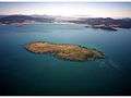
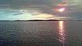
Aerial photograph of Smooth Island with Dunalley in the background | |
 Smooth Island Location in Tasmania | |
| Etymology | Matthew Flinders, 1798 |
|---|---|
| Geography | |
| Location | Norfolk Bay |
| Coordinates | 42°56′24″S 147°46′48″E / 42.94000°S 147.78000°E |
| Archipelago | Sloping Island Group |
| Area | 0.61 km2 (0.24 sq mi) |
| Coastline | 3.38 km (2.1 mi) |
| Highest elevation | 44 m (144 ft) |
| Administration | |
| State | Tasmania |
| Land district | Pembroke |
| Local government area | Tasman Council |
| Additional information | |
| Time zone | |
| • Summer (DST) | |
The Smooth Island, part of the Sloping Island Group, is a privately owned island with an area of 59.31 hectares (146.6 acres)[1] lying close to the south-eastern coast of Tasmania, Australia. The island is situated in Norfolk Bay, surrounded by the Tasman and Forestier Peninsulas.[1] The towns Dunalley and Murdunna are nearby and for administrative purposes, the island is within the Tasman Council, the land district of Pembroke and the electorate of Lyons at state and federal levels. Smooth Island is particularly unique as it is one of the only islands in Tasmania where absolutely all of the land (up to the waterline) is privately owned and managed through unrestricted freehold tenure.
History
Between 1835 and 1855 the island may have been used to grow vegetables for the Port Arthur penal colony.[2] By 1869 the land was cultivated: The island had two or three cottages which featured a garden, as well as grazing livestock. The burnt remains of a fireplace are still present on the island. During the 1990s the island was used to host private international pheasant and quail shooting meetings.[2] Between 2003 and 2007 the island was used to transport oyster stock to and from a processing facility in Boomer Bay.[3]
Ecology
Terrestrial
Fauna

Smooth Island is home to a wide range of native Australian birds. Recorded breeding seabird species are little penguin (Eudyptula minor), little pied cormorant, black-faced cormorant, great cormorant and short-tailed shearwater (Ardenna tenuirostris).[1] The latter predominantly habitates inland from the western to southern coasts.[4] The following native birds occupy the island: Tasmanian nativehen and forest raven.[1] The Pacific gull also occupies the island.[5] A survey by the Department of the Environment (Australia) in 2010 revealed the presence of the Eurasian skylark (Alauda arvensis), house sparrow (Passer domesticus), common pheasant (Phasianus colchicus), common starling (Sturnus vulgaris) and common blackbird (Turdus merula) on the island.[6] The presence of sea eagle, wedge-tailed eagle, kelp gull, tern, silver gull, oystercatcher, cormorant and gannet species have also been described.[7] No reptiles have been recorded on the island apart from a small population of blue tongue lizards.[1] The hooded plover (Thinornis cucullatus) is a threatened species which may be present on the Smooth Island.[8]
Flora
The island has been classified as a drooping she-oak (Allocasuarina verticillata) forest, despite having relatively sparse foliage. Large macrocarpa have been identified around the remnants of an old cottage on the north-east coast. Eucalyptus globulus and Allocasuarina striata (small bull-oak) are also present on the island.[9] The Marrubium vulgare weed has been identified towards the island's north. Occasional Blackberry bushes have been identified near the Southern peak and southern shoreline. Kangaroo apple is also occasionally found along the southern shoreline.[10] The island's fire attributes are "medium flammability, low sensitivity".[4]
Marine
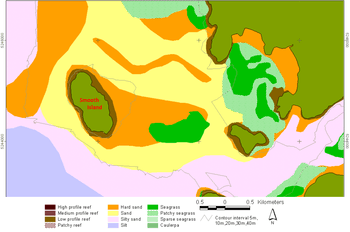
Smooth Island is surrounded by a low profile reef. A region of gravel or hard sand extends from the reef on the eastern coast towards King George Island and King George Sound. The reef on the western coast is surrounded by sand and a body of silt approaches the south-west coast of the island. Between Smooth Island and King George Island lies a dense bed of seagrass (Halophila australis) and eelgrass (Zostera tasmanica) approximately 12.5 hectares in size.[11] Studies have found dense populations of South Australian cobbler (Gymnapistes marmoratus) within this region, as this fish has a preference for patchy beds of eelgrass.[12] A species of red algae (Rhabdonia verticillata)[13][14] has been found very close to the island.[15] The following fish can be found in the waters immediately surrounding the island: flathead, trumpeter, perch, cod and Australian salmon. Dolphins are frequently sighted and whales[16] are infrequently sighted near the island.[7][17] The Spotted handfish and the Live-bearing Seastar (Parvulastra vivipara) are threatened marine species which may be present in the waters surrounding Smooth Island.[8] A killer whale (Orcinus orca) was identified 1 kilometre north-east of the current lighthouse position.
Ecological rehabilitation
The terrestrial ecosystem of Smooth Island has previously been damaged through overgrazing, slashing-and-burning[18] and through the commercial hunting of wildlife.[19] The island's natural vegetation has been largely displaced with exotic grass, thistle, bracken, scattered eucalypts and African boxthorn bushes. Between 0.86[20] and 18 hectares of shearwater rookeries are present on Smooth Island and the impact of repeated fires on these habitats has been studied.[18]
The current owners intend to systematically restore the island's native ecosystem. Since March 2014, a diverse range of native Tasmanian flora have been planted throughout the island.[21] Remnant eucalypts are also expected to seed from the island's south-east coast now that grazing has ceased.
Landscape
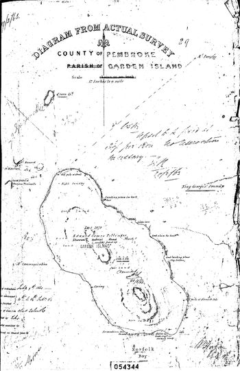
A formally commissioned survey of Smooth Island was completed on the 14th of July 1863 (see inset). In particular, it reveals the presence of the original jetty, a spring and a guano excavation on the island.
Smooth Island has two hilly peaks separated by a saddle. The North peak, South peak and saddle are located at 42°56′40″S 147°46′56″E / 42.9444°S 147.78219°E, 42°56′56″S 147°47′10″E / 42.94877°S 147.7862°E and 42°56′46″S 147°47′05″E / 42.9461°S 147.78472°E respectively. The height above sea level of the North peak, South peak and saddle are 43 metres, 40 metres and 30 metres respectively.[note 1] Smooth Island lies 2.24 km (1.39 mi) from both Dunbabin Point[22] and Chronicle Point on the mainland and lies 2.3 km (1.4 mi) from King George Island, measured from the nearest coastlines.
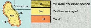
Smooth Island consists of diabase (or dolerite) rock, a subvolcanic intrusion which probably occurred from 56 to 33.9 million years ago during the Eocene epoch of the Cenozoic era.[23] A geological survey identified consolidated brownish fine-grained quartz sandstone occurring on the north east coastline of Smooth Island at approximately 2 metres above sea level, covered by sand. It was said to be similar to the sandstone samples retrieved from South Arm which contained numerous fossils, but no fossils were found in the samples taken from Smooth Island.[24][25] The western aspect of the island contains Dolerite (tholeiitic) with locally developed granophyre, from the Jurassic period.
Given the island predominantly has a sloping hard rock shore, there is minimal vulnerability to flooding or erosion due to a rise in sea level.[4] A "coastal acid sulfate soil analysis" was conducted producing a result of "extremely low" along the north/north east side of the island.[4] On 13 October 1941, a geological survey of Smooth Island was conducted to determine the possibility of mining phosphate on the island, concluding that phosphate mining on Smooth Island was unlikely to be viable. Further details of this study are available.[26]
Nomenclature
Matthew Flinders discovered the island on 15 December 1798 and named it "Smooth Island" as it appears on his maps at the time[27][28] however the island did not appear on his subsequent map in 1814.[29] In 1824 Thomas Scott referred to Smooth Island as Garden Island in his maps. The origins of this are not entirely clear, however this probably explains why the island was referred to as Garden Island between the early 1800 and the mid 1900s.
According to a 1911 newspaper article, the island "is not named in the map of D'Entrecasteaux, even though it was marked".[30] During the early 21st century, Smooth Island was occasionally listed as "Lot 1 Norfolk Bay, Dunalley TAS 7177" on certain real-estate classifieds.[31]
Much confusion exists about the names of many of the islands in South East Tasmania. Garden Island is an island along the Huon River, but Garden Island has become the pseudonym for both Green Island[32] as well as Smooth Island. A newspaper article from 1836 refers to a Garden Island in both the Pembroke as well as Buckingham land districts of Tasmania.[33] Green Island in turn has become a pseudonym for Fulham Island. Doughboy Island has replaced Isle of Caves[34]
Tenure
All of Smooth island is private property. It has a freehold title with no covenants whatsoever.
In 2014 Smooth Island was gazzetted as a Private Forest Timber Reserve
Climate
| Climate data for Hobart International Airport (26 km (16 mi) from Smooth Island) | |||||||||||||
|---|---|---|---|---|---|---|---|---|---|---|---|---|---|
| Month | Jan | Feb | Mar | Apr | May | Jun | Jul | Aug | Sep | Oct | Nov | Dec | Year |
| Average high °C (°F) | 22.6 (72.7) |
22.3 (72.1) |
20.8 (69.4) |
18.1 (64.6) |
15.3 (59.5) |
12.9 (55.2) |
12.5 (54.5) |
13.5 (56.3) |
15.4 (59.7) |
17.3 (63.1) |
19 (66) |
20.7 (69.3) |
17.53 (63.53) |
| Average low °C (°F) | 12 (54) |
12.1 (53.8) |
10.8 (51.4) |
8.8 (47.8) |
6.6 (43.9) |
4.6 (40.3) |
4.1 (39.4) |
4.7 (40.5) |
6.1 (43) |
7.5 (45.5) |
9.2 (48.6) |
10.8 (51.4) |
8.11 (46.63) |
| Average precipitation mm (inches) | 40.8 (1.606) |
35.9 (1.413) |
36.1 (1.421) |
42.2 (1.661) |
35.6 (1.402) |
32.5 (1.28) |
43.8 (1.724) |
47.1 (1.854) |
41.6 (1.638) |
46.3 (1.823) |
44.9 (1.768) |
52.6 (2.071) |
499.4 (19.661) |
| Source: Australian Bureau of Meteorology (1958-2015) [36] | |||||||||||||
Access
Smooth Island is easily accessible by boat or helicopter. The island's smooth and gently undulating topography also favours the construction of a small airstrip for light planes in the future.
Services and facilities
The table below outlines the nearest services and facilities to Smooth Island.
| Service type | Name | Address | Coordinates | Distance by air | Distance by boat | Distance by road from Murdunna | Reference |
|---|---|---|---|---|---|---|---|
| Public boat ramp | Murdunna boat ramp | Sommers Bay Road, Murdunna, Tas 7173 | 42°56′45″S 147°51′18″E / 42.945952°S 147.855128°E | 5.7 km | 5.8 km | - | [37] |
| Ambulance | Dodges Ferry Ambulance Station | Tiger Head Rd, Dodges Ferry, Tas 7173 | 42°51′27″S 147°36′41″E / 42.857603°S 147.611366°E | 17 km | 21 km | 28 km | [38] |
| Medical (family doctor) | Dodges Ferry Medical | 52 Carlton Beach Rd, Dodges Ferry, Tas 7173 | 42°51′28″S 147°37′04″E / 42.857818°S 147.617753°E | 17 km | 21 km | 28 km | [39] |
| Major hospital | Royal Hobart Hospital | 48 Liverpool St, Hobart, Tas 7000 | 42°52′48″S 147°19′46″E / 42.879905°S 147.329534°E | 37.5 km | 56 km | 65 km | [40] |
| Police (and defibrillator) | Dunalley Police Station | 126 Arthur Hwy, Dunalley, Tas 7177 | 42°53′14″S 147°48′37″E / 42.887223°S 147.810238°E | 6.7 km | 6.7 km | 9 km | [41] |
| Mobile phone transmission tower | Telstra 3G 850 MHz | 17 Constance St, Dunalley, Tas 7177 | 42°53′23″S 147°48′21″E / 42.889719°S 147.805765°E | 6 km | - | - | [42] |
| Wireless internet transmission tower | National Broadband Network | 17 Constance St, Dunalley, Tas 7177 | 42°53′23″S 147°48′21″E / 42.889719°S 147.805765°E | 6 km | - | - | [42] |
| Fuel | Shell Dunalley | 119 Arthur Hwy, Dunalley, Tas 7177 | 42°53′14″S 147°48′43″E / 42.887226°S 147.812031°E | 6.5 km | 6.5 km | 9 km | [43] |
| General store | Dunalley Supermarket | 168 Arthur Hwy, Dunalley, Tas 7177 | 42°53′22″S 147°48′22″E / 42.889480°S 147.806124°E | 6.7 km | 6.7 km | 9 km | [44] |
| Large shopping centre | Sorell plaza shopping centre | Cole Street, Sorell, Tas 7172 | 42°46′57″S 147°33′59″E / 42.782389°S 147.566468°E | 25 km | 29 km | 40 km |
The island receives radio coverage from ABC Local Radio (936 AM), 3G mobile phone coverage from Telstra and wireless coverage from the National Broadband Network.
Features
A lighthouse with the international marker identifier K 3621.2 was present on Smooth Island. However, since the island is private property to the water line, in 2014 Marine and Safety Tasmania were obligated to relocate it into the ocean around the northern tip of the island. The lighthouse was relocated to the following position: 42°56′24″S 147°46′53″E / 42.9399167°S 147.7812667°E.[45] The light characteristic remains unchanged since this relocation. Its height is 2 metres (6 feet). The light's range was 6 nautical miles in clear weather. It is a stainless steel pole in the water. The technical specifications of the lighthouse are: FL(3)W, period 6.1 seconds (i.e.: a cluster of 3 flashes of a white light is produced, which repeats every 6.1 seconds).[46]
Modern culture
.jpg)

Smooth Island has been the subject of a range of artistic works. Michael Weitnauer[47] won first prize at the Wrest Point Art Award with his painting of Smooth Island.(The Mercury, 7 January 2002). The Australian artist Dale Frank also produced a painting named "Dunalley, Smooth Island".[48] Smooth Island and its lighthouse have also featured in poetry:[49]
I could lose or find myself
in this private Bermuda triangle-
Connelly's Bay, Lime Bay, Smooth Island;
In the dusk Smooth Island's navigation light
begins to blink its code name
to sailors bound for Dunalley
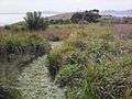
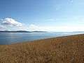
Gallery


See also
-
 Media related to Smooth Island (Tasmania) at Wikimedia Commons
 - List of islands of Tasmania
Footnotes
- ↑ Measured on 30/12/15 using barometric function of Garmin Monterra. Sea level calibrated to 0 metres when tide was at 1.11m. After the first set of measurements the device was recalibrated to sea level (-7cm) and the altitude of the 3 features was reassessed, increasing the altitude of all points by 1 metre. It is the second set of measurements which have been recorded. Conditions: pressure 1015.4 hPa, humidity 53%, 20.4km NE wind, no rain, dew point 12.7 degrees Celsius.
References
- 1 2 3 4 5 "Tasmania's offshore islands". Books.google.com.au. Retrieved 13 July 2015.
- 1 2 "Living in History". Books.google.com.au. Retrieved 2015-07-13.
- ↑ "533 SCHEME AMENDMENT- BOOMER JETTY ROAD, BOOMER BAY.docx". Google Docs.
- 1 2 3 4 "Listmap: Land Information System Tasmania". Maps.thelist.tas.gov.au. Retrieved 28 December 2014.
- ↑ http://dpipwe.tas.gov.au/Documents/finalreportwithcovers.pdf
- ↑ "Ferals offshore islands". Environment.gov.au. Retrieved 28 December 2014.
- 1 2 "Murdunna - RBasket (Real Estate Basket), Best Search Engine for Real Estate". rbasket.com.au. Retrieved 2015-03-22.
- 1 2 http://dpipwe.tas.gov.au/Documents/threatfauna.pdf
- ↑ "Murdunna, TAS 7178 Vacant land is recently sold". domain.com.au. Retrieved 2015-03-22.
- ↑ http://www.anbg.gov.au/gnp/gnp12/solanum-laciniatum.html
- ↑ "Mapping of Inshore Marine Habitats" (PDF). Imas.utas.edu.au. 2001. Retrieved 28 December 2014.
- ↑ "FRDC 1994" (PDF). 1998. Retrieved 28 December 2014.
- ↑ "Rhabdonia verticillata" (PDF). Flora.sa.gov.au. Retrieved 2015-07-13.
- ↑ "Rhabdonia verticillata, State Herbarium of South Australia". flora.sa.gov.au. Retrieved 2015-04-06.
- ↑ "Halogenated phloroglucinols from Rhabdonia verticillata". Phytochemistry. 21: 2141–2142. doi:10.1016/0031-9422(82)83072-0. Retrieved 2015-04-06.
- ↑ "18 Jul 1894 - SHIPPING. ARRIVED.—Yesterday.". nla.gov.au.
- ↑ "Murdunna TAS 7178". Domain. Retrieved 2015-03-22.
- 1 2 Nigel Brothers; Stephen Harris (1999). "THE EFFECTS OF FIRE ON BURROW-NESTING SEABIRDS PARTICULARLY SHORT-TAILED SHEARWATERS (PUFFINUS TENUIROSTRIS) AND THEIR HABITAT IN TASMANIA" (PDF). The Royal Society of Tasmania. Flora.sa.gov.au. 133. Retrieved 2015-07-13.
- ↑ "Currawong Lakes : What's New for 2010" (PDF). Currawonglakes.com.au. Retrieved 11 January 2015.
- ↑ "DISTRIBUTION, ABUNDANCE AND CONSERVATION STATUS OF SHORT-TAILED SHEARWATERS PUFFINUS TENUIROSTRIS IN TASMANIA, AUSTRALIA" (PDF). Marineornithology.org. Retrieved 11 January 2015.
- ↑ "An island of your own". Mercury. Retrieved 2015-04-06.
- ↑ "Australia pilot". Books.google.com.au. Retrieved 2015-07-13.
- ↑ Mineral Resources of Australia. Books.google.com/np. Retrieved 11 January 2015.
- ↑ "Sorell Map" (PDF). Mrt.tas.gov.au. Retrieved 2015-07-13.
- ↑ A. B. Gulline, B.Sc. "Geological Survey Explanatory Report: Sorrell" (PDF). Tasmania Department of Mines. Retrieved 28 December 2014.
- ↑ "Phosphate Rock – Garden Island – Norfolk Bay" Department of State Growth, Government of Tasmania. Retrieved 20 February 2015
- ↑ M Flinders (1798). "Chart of Terra Australis" (JPG). Gutenberg.net.au. Retrieved 2015-07-13.
- ↑ "Nomina geographica". Books.google.com.au. Retrieved 2015-07-13.
- ↑ "09 Sep 1911 - TASMANIAN NOMENCLATURE. THE PLACE-NAMES OF THE I...". nla.gov.au.
- ↑ "Tasmanian Nomenclature: The Place-Names of the State, a Record of Origins and Dates". Trove.nla.gov.au. 16 September 1911. Retrieved 28 December 2014.
- ↑ "Lot 1 Norfolk Bay, Dunalley, TAS 7177 - Bedroom House For Sale". domain.com.au. Retrieved 2015-04-06.
- ↑ "History". Gtdhs.com. Retrieved 11 January 2015.
- ↑ "15 Jan 1836 - Classified Advertising". nla.gov.au. Retrieved 2015-04-11.
- ↑ "A Voyage to Terra Australia, Undertaken for the Purpose of Completing the ... - Matthew Flinders - Google Books". Books.google.com.au. Retrieved 2015-07-13.
- ↑ "Map i Tenure". Parks.tas.gov.au. Retrieved 2015-07-13.
- ↑ "Climate statistics for Australian locations". bom.gov.au. Retrieved 2015-04-11.
- ↑ Ionata Digital. "Murdunna Boat Ramp". MAST.
- ↑ "Ambulance Service - Dodges Ferry - Department of Health and Human Services". dhhs.tas.gov.au.
- ↑ "Doctors, GPs & Medical Centres in Dodges Ferry, TAS 7173". HealthEngine.
- ↑ "Royal Hobart Hospital - Hospitals". dhhs.tas.gov.au.
- ↑ "Tasmania Police". police.tas.gov.au.
- 1 2 "Oz Towers, Search for towers in your area.". oztowers.com.
- ↑ "Service Stations in Dunalley, TAS 7177 Australia - Whereis®".
- ↑ "Dunalley General Store". womo.com.au. 9 August 2009.
- ↑ Ionata Digital. "M46-14 Smooth Island Light". MAST. Retrieved 14 February 2015.
- ↑ Prostar Nga List of Lights, Radio AIDS and Fog Signals 2006 West Coasts of ... Books.google.com.au. Retrieved 11 January 2015.
- ↑ "Michael Weitnauer Artist". Michael Weitnauer Artist.
- ↑ "ART GALLERIES". schubertcontemporary.com.au. Retrieved 2015-04-06.
- ↑ Two Kinds of Silence. Books.google.com.np. Retrieved 11 January 2015.
South Eastern region of Tasmania, Australia | |||||||
|---|---|---|---|---|---|---|---|
| Governance former | |||||||
| Mountains |
| ||||||
| Protected areas, parks and reserves |
| ||||||
| Rivers | |||||||
| Harbours, bays, inlets and estuaries | |||||||
| Transport | |||||||
| Landmarks |
| ||||||
| Islands |
| ||||||
| Books and newspapers | |||||||
| Bioregions | |||||||
| |||||||