Low Islets (Tasmania)
For other places with the same name, see Low Islets (disambiguation).
|
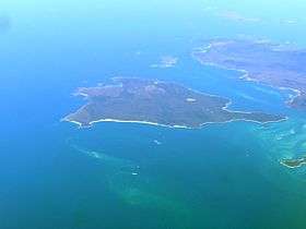
An aerial view of Clarke Island, centre; with the Low Islets being two small islands in foreground; with Spike Island closer to Clarke Island. | |
 Low Islets Location of the Low Islets in Bass Strait | |
| Geography | |
|---|---|
| Location | Bass Strait |
| Coordinates | 40°33′36″S 148°14′24″E / 40.56000°S 148.24000°ECoordinates: 40°33′36″S 148°14′24″E / 40.56000°S 148.24000°E |
| Archipelago | Passage Group, part of the Furneaux Group |
| Total islands | 2 |
| Area | 2 ha (4.9 acres) |
| Administration | |
|
Australia | |
| State | Tasmania |
The Low Islets, part of the Passage Group within the Furneaux Group, is a close pair of unpopulated small granite islands with a combined area of 2 hectares (4.9 acres), located in Bass Strait, south of Cape Barren Island, and west of both Spike and Clarke islands, in Tasmania, in south-eastern Australia.[1][2]
Fauna
The island is one of only three sites where pelicans breed in Tasmania.[2] Recorded breeding seabird, wader and waterbird species include little penguin, Pacific gull, silver gull, sooty oystercatcher, black-faced cormorant, Australian pelican, Caspian tern, crested tern and white-fronted tern.[3]
See also
References
- ↑ "Low Islets (TAS)". Gazetteer of Australia online. Geoscience Australia, Australian Government.
- 1 2 "Small Bass Strait Island Reserves. Draft Management Plan". Department of Primary Industries,Water and Environment, Tasmanian Government. October 2000. Retrieved 4 February 2012.
- ↑ Brothers, Nigel; Pemberton, David; Pryor, Helen; & Halley, Vanessa. (2001). Tasmania’s Offshore Islands: seabirds and other natural features. Tasmanian Museum and Art Gallery: Hobart. ISBN 0-7246-4816-X
This article is issued from Wikipedia - version of the 11/24/2016. The text is available under the Creative Commons Attribution/Share Alike but additional terms may apply for the media files.