Robbins Island (Tasmania)
 Robbins Island Location of Robbins Island in the Bass Strait | |
| Etymology | Charles Robbins[1] |
|---|---|
| Geography | |
| Location | Bass Strait |
| Coordinates | 40°41′24″S 144°54′36″E / 40.69000°S 144.91000°ECoordinates: 40°41′24″S 144°54′36″E / 40.69000°S 144.91000°E |
| Area | 99 ha (240 acres) |
| Area rank | 7th in Tasmania[2] |
| Administration | |
|
Australia | |
| State | Tasmania |
| LGA | Circular Head Council |
The Robbins Island is a 99-hectare (240-acre) island located in Bass Strait, lying off the northwest coast of Tasmania, Australia.[3] The island, separated from the Tasmanian mainland by a highly tidal area known as Robbins Passage,[4] lies south to the adjacent Walker Island.[5]
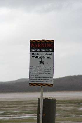
Robbins Islands is the seventh largest island of Tasmania[2] and is the largest freehold island in Tasmania.[6] Over the years Robbins Island has changed ownership and to this day remains privately owned.[7]
History
The island was part of the territory of the indigenous North West tribe spanning from Table Cape to the western side of Macquarie Harbour,[8] where in particular, the Parperloihener band resided on Robbins Island prior to European colonisation.[9] On 23 November 1802,[10] Charles Robbins, first mate of Buffalo was sent in Cumberland, by Governor King to dissuade the French commodore Nicholas Baudin, with his two ships Géographe and Naturaliste from colonising Van Diemen's Land.
Baudin had revealed French plans to colonise Van Diemen's Land when drunk in a farewell party organised by the Governor, after sailing into Port Jackson where his crew were treated back to health from scurvy. Governor King would not accept French occupation of Van Diemen's Land and chartered the schooner Cumberland to which in 13 December 1802,[10] Robbins used successfully, persuading Baudin to abandon French settlement on Van Diemen's Land. The schooner was chartered as larger ships were away and used for other maritime activities.[11] From there along with Charles Grimes, Robbins sailed to Port Phillip, and actively explored the Yarra River in 1803 before returning to Port Jackson.[12] It was during a subsequent trip to retrieve two Spanish ships which had been captured by a NSW trader's privateering expedition and hidden off the coast of Deal Island that in 1804 Robbins discovered Robbins island, which is named after him.[1][13]
In 1826, following the English occupation of Tasmania, the Van Diemen's Land Company was set up at Stanley. This company was formed in England by London-based businessmen, who wanted to utilise land in Tasmania to create a wool industry to supply the British textile industry, which intention was facilitated by William Sorrell's account to the Colonial Office that the Tasmanian colony was desperate for capital.[14][15] The Van Diemen's Land Company Act was passed transferring possession of 250,000 acres (100,000 ha) of Crown land to freehold status or private ownership and included Robbins Island.[16] A series of disputes during the period of 1820 to 1840, between European settlers and the North West tribe, in which Van Diemen's Land Company chief agent Edward Curr authorised the use of force if 'required', escalated into battles which became violent and bloody, notably including the infamous Cape Grim massacre.[17][18] This culminated in the attempted genocide of what is now known as the Black War.[19] In 1835 under George Robinson, almost all Indigenous people from the Tamanian mainland, including the Parperloihener band from Robbins Island, were removed and transported to a reserve on Flinders Island.[7][19]
Topography and fauna
The island has a number of topographical features which include:
- Cape Elie[20][21] the most easterly point of the island.[21]
- Guyton Point,[22] located on northeastern area of the island.[23]
- Mosquito Inlet is an estuary northwest of the island, having an area of 674 hectares (1,670 acres),[24] where four bird species, the eastern curlew, masked lapwing, pied oystercatcher and sooty oystercatcher roost.[25]
- Five Islets, located northwest of the island, where the fairy tern and pied oystercatcher permanently nest, along with migratory birds great knot, red knot, bar-tailed godwit, grey plover, lesser sand plover, common greenshank, red-necked stint, Terek sandpiper and ruddy turnstone can be found.[25]
- Bird Point,[25] also located northwest of Robbins Island where a number of birds species permanently roost in the area. They include: fairy terns, little terns, Caspian terns, crested terns, pied oystercatchers and sooty oystercatchers. Many species of migratory birds come to nest here and include grey-tailed tattlers, great knots, lesser sand plovers, masked lapwings, Pacific golden plovers, red knots, red-capped plovers, red-necked stints, ruddy turnstones, sanderlings, waders, double-banded plovers, curlew sandpipers, common greenshanks, bar-tailed godwit and hooded plovers.[25]
Current developments
The island was used by livestock to graze on, primarily for wool production[14] before the 1850s.[26] William B. Reid leased the island for 43 years commencing in 1873,[27][28] where native animals on the land were used as wild game,[29] farming[30] and dairy products were made.[31] Bill and Norah Holyman then bought the island in 1916 using it for sheep husbandry,[32][33] selling off the island in 1958.[34] In 1961, H E Hammond was the owner of the island,[35] where it remains in family ownership today.[36] His descendants, Keith and John Hammond currently produce on Robbins Island wagyū beef, which is exported to Japan.[6][37][38] Commercial aquaculture industry from Circular Head presently harvest rock lobster and abalone in waters around the island.[39] A wind farm has been proposed to be built on the island and was expected to be fully operational by 2014;[40] yet by 2016 the wind farm had not been constructed.[41]
See also
References
- 1 2 "ROBBINS, Charles (Lieutenant). Master, "Integrity"". Colonial Secretary Index, 1788-1825 - Roads (1817) to Roberts, H. State Records NSW - Department of Services, Technology & Administration. November 2002. Retrieved 9 January 2010.
- 1 2 "1384.6 - Statistics - Tasmania, 2008". Australian Bureau of Statistics. 3 January 2008. Retrieved 10 January 2010.
- ↑ "Robbins Island (TAS)". Gazetteer of Australia online. Geoscience Australia, Australian Government.
- ↑ "Scalefish Fishery Management Plan Review Information Paper" (PDF). Tasmanian Scalefish Fishery Management Plan. State Library of Tasmania. March 2004. Retrieved 9 January 2010.
- ↑ "False Killer Whale stranding, Walker's Island, Tasmania". National Whale and Dolphin Sightings and Strandings Database. Australian Government - Department of the Environment and Water Resources. January 2010. Retrieved 10 January 2010.
- 1 2 "Steer way to heaven for Japan's top meat". What the papers said... Sunday Tasmanian. 27–28 August 2006. Retrieved 9 January 2010.
- 1 2 Ryan, L (1996). The Aboriginal Tasmanians. Allen & Unwin Academic - 2nd edition. pp. 139, 283. ISBN 1-86373-965-3. Retrieved 9 January 2010.
- ↑ "Introduction - History" (PDF). Local governmenet board - Reports into the findings of a general review - Circular Head Council. Department of Premier and Cabinet - Tasmania. March 2006. Retrieved 10 January 2010.
- ↑ "18: History" (PDF). Circular Head Profile. Circular Head Council. January 2009. Retrieved 9 January 2010.
- 1 2 Coroneos, J., Hadlow, J., Rice, A. & Robertson, J. "1802". The World Upside Down - Australia 1788-1830. National Library of Australia. Retrieved 9 January 2010.
- ↑ "The Hobart Circuit, Tasmania - The Founding of Hobart" (PDF). The Spectator/University of Tasmania. n.d. Retrieved 9 January 2010.
- ↑ State Library of New South Wales (2007). "Manuscript, Oral history & pictures - Record Details". Collection Record Details. State Library of New South Wales. Retrieved 9 January 2010.
- ↑ Olijnyk, E., Robbins, T. & Robins, A. (January 2003). "The Famous one". Australia's first Robbins' - both Famous and Infamous. Robbins Genealogy. Retrieved 9 January 2010.
- 1 2 "Agency Details - Van Diemen's Land Company". Tasmanian Archives Online database. Archives Office of Tasmania. January 2006. Retrieved 10 January 2010.
- ↑ "Curr, Edward (1798 - 1850)". Australian dictionary of biography - Online edition. Australian National University. 2006. Retrieved 10 January 2010.
- ↑ Bischoff, J. (1832). Sketch of the history of Van Diemen's Land: illustrated by a map of the island, and an account of the Van Diemen's Land Company. United Kingdom: John Richardson, Royal Exchange. p. 105. Retrieved 10 January 2010.
- ↑ "History". Highfield. Parks & Wildlife Service - Tasmanian Department of Primary Industries, Parks, Water and Environment. 16 July 2008. Retrieved 10 January 2010.
- ↑ Mansell, M. (1995). "Briefs: Native Title – A New Legal Shield". Aboriginal Law Bulletin. Australasian Legal Information Institute/University of New South Wales/University of Technology, Sydney. Retrieved 10 January 2010.
- 1 2 "The 'Black War'" (PDF). The History: Tasmania - resource sheet. Human Rights and Equal Opportunity Commission. December 2007. Retrieved 9 January 2010.
- ↑ "Appendix 10: Environmental Monitoring in the Far North West Marine Farming Development Plan Area 1997–2002" (PDF). Tasmanian Marine Farming Environmental Monitoring Report: Benthic Monitoring (1997–2002). Marine Environment Section - Marine Farming Branch = Marine Resources Group - Department of Primary Industries, Water and Environment. 2004. Retrieved 9 January 2010.
- 1 2 "Cape Elie, Tasmania (Points, Capes & Peninsulas)". Gazetteer of Australia online. Geoscience Australia, Australian Government. Retrieved 10 January 2010.
- ↑ Bottrill, R.S. & Everard, J.L. (April 1997). "Zeolites in Tasmania" (PDF). Tasmanian Geological Survey. Mineral Resources Tasmania. Retrieved 9 January 2010.
- ↑ Everard, J.L., Calver, C.R., Pemberton, J., Taheri, J., Dixon, G. and Quility, P.G. "Geology of the islands of southwestern Bass Strait." Department Mineral Resources Tasmania. June 2000. Accessed 10 January 2010.
- ↑ "Estuaries in Tasmania". State of the Environment 2009. Tasmanian Planning Commission. 18 December 2009. Retrieved 10 January 2010.
- 1 2 3 4 Bryant, S. (2002). "Conservation assessment of beach nesting and migratory shorebirds in Tasmania" (PDF). Natural Heritage Trust Project. Nature Conservation Branch - Department Primary Industries Water and Environment. Retrieved 9 January 2010.
- ↑ "Portrait of Mrs Jane Evans wife of Edward". eHeritage. State Library of Tasmania. n.d. Retrieved 9 January 2010.
- ↑ "Ketch - 'Welcome' built on Robbins Island, Tasmania". eHeritage. State Library of Tasmania. n.d. Retrieved 9 January 2010.
- ↑ "William Reid mowing oats on Robbins Island. Circa 1900". eHeritage. State Library of Tasmania. n.d. Retrieved 9 January 2010.
- ↑ "William Reid skinning a wallaby on Robbins Island". eHeritage. State Library of Tasmania. n.d. Retrieved 9 January 2010.
- ↑ "William Reid mowing oats on Robbins Island. Circa 1900". eHeritage. State Library of Tasmania. n.d. Retrieved 9 January 2010.
- ↑ "Loading cheese into a plane on Robbins Island". eHeritage. State Library of Tasmania. n.d. Retrieved 9 January 2010.
- ↑ "Bullock team hauling wool bales on Robbins Island". eHeritage. State Library of Tasmania. n.d. Retrieved 9 January 2010.
- ↑ "Holyman, William (1858 - 1921)". Australian Dictionary of Biography - Online Edition. Australian National University. 2006. Retrieved 9 January 2010.
- ↑ "Bill and Norah Holyman of Robbins Island". eHeritage. State Library of Tasmania. n.d. Retrieved 9 January 2010.
- ↑ "Item Details". Tasmanian Archives Online database. Archives Office of Tasmania. 17 January 2006. Retrieved 10 January 2010.
- ↑ "Tassie beef wins paddock to palate". ABC Rural News. Australian Broadcasting Corporation. 1 February 2001. Retrieved 9 January 2010.
- ↑ "Trove - Tetsuya's taste of Tasmania Gourmet Traveller". National Library of Australia. n.d. Retrieved 10 January 2010.
- ↑ "Hammond Farms". Hammond Farms Wagyu Cattle. n.d. Retrieved 10 January 2010.
- ↑ "5: Economic Activity" (PDF). Circular Head Profile. Circular Head Council. January 2009. Retrieved 10 January 2010.
- ↑ "Tasmanian Energy Supply Industry Performance Report 2008-09" (PDF). Office of the Tasmanian Economic Regulator. December 2009. Retrieved 9 January 2010.
- ↑ Cocard, Rachel (7 March 2016). "Energy crisis fuels push for wind farm". The Advocate. Retrieved 5 July 2016.