Moriarty Rocks
|
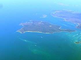
An aerial view of Clarke Island, centre; with the Moriarty Rocks at the bottom of the picture. | |
 Moriarty Rocks Location of the Moriarty Rocks in Bass Strait | |
| Geography | |
|---|---|
| Location | Bass Strait |
| Coordinates | 40°34′48″S 148°16′12″E / 40.58000°S 148.27000°ECoordinates: 40°34′48″S 148°16′12″E / 40.58000°S 148.27000°E |
| Archipelago | Passage Group, part of the Furneaux Group |
| Total islands | 2 |
| Area | 2.46 ha (6.1 acres) |
| Administration | |
|
Australia | |
| State | Tasmania |
The Moriarty Rocks, part of the Passage Group within the Furneaux Group, are a group of two major unpopulated granite rocks, and several smaller ones, with a combined area of 2.46 hectares (6.1 acres), located in Bass Strait, south of Cape Barren Island, west of the Low Islets, and west of the Spike and Clarke islands, in Tasmania, in south-eastern Australia.[1] The rocks are contained within a nature reserve.[2]
Flora and fauna
There is little vegetation on the rocks, due to them being frequently wave-washed. black-faced cormorants breed there, and they hold an important breeding colony of Australian fur seals, with up to about 1000 pups being born there annually.[3]
See also
References
- ↑ "Moriarty Rocks (TAS)". Gazetteer of Australia online. Geoscience Australia, Australian Government.
- ↑ "Small Bass Strait Island Reserves. Draft Management Plan". Department of Primary Industries,Water and Environment, Tasmanian Government. October 2000. Retrieved 4 February 2012.
- ↑ Brothers, Nigel; Pemberton, David; Pryor, Helen; & Halley, Vanessa. (2001). Tasmania’s Offshore Islands: seabirds and other natural features. Tasmanian Museum and Art Gallery: Hobart. ISBN 0-7246-4816-X
This article is issued from Wikipedia - version of the 11/24/2016. The text is available under the Creative Commons Attribution/Share Alike but additional terms may apply for the media files.