History of Smooth Island (Tasmania)
This article outlines the history of Smooth Island in Norfolk Bay, Tasmania.
History

.png)
Prior to European settlement, the Forestier Peninsula to the east of Smooth Island is believed to have been occupied by the Pydairrerme band of the Oyster Bay (Paredarerme) tribe of Aboriginal Tasmanians.[1][2][3] They spoke the Paredarerme language. There is no recorded evidence of any remaining Paredarerme people in the region after the 1830s.[3]
European settlement
In 1793, Jean-Baptiste Philibert Willaumez (of the Antoine Bruni d'Entrecasteaux expedition) was the first Anglo-Saxon to discover Smooth Island. Smooth island is found on the maps drawn up by Antoine Bruni d'Entrecasteaux, however the island is unnamed on these maps.[4]
On 15 December 1798, Matthew Flinders was the first Anglo-Saxon to set foot on Smooth Island. It appears he spent two nights on the island. His impression of the island has been described as follows:[4]
(They) moved on to another island which, from a distance, appeared unusually attractive. At close quarters, the island seemed every bit as beautiful as it did from afar. Its surface was smooth and the texture of its soil contained a richness which is rarely found in uncultivated land. It was estimated that there must have been at least one hundred acres of good, yielding agricultural ground. But the unhappy and unforseen part of this seemingly natural course taken by the sloop was the denial of the sighting by the ship's personnel of an isthmus which would have been of great importance to them.
But "Smooth Island", as they so aptly named it, was indeed delectable and aforded them two delightful days in exploring its scenery and absorbing its charm and beauty. They observed that the Aborigines paid this scenic spot many visits because of its garden-like qualities as compared with the stony-like terrain of the mainland which, although well-wooded and contained many kangaroos, seemed harsh and uninviting in comparison to their "Garden Island", a title it eventually acquired.
[5] He charted the island and his passage through the region on the map Chart of Terra Australis - By M Flinders - 1798-1799 - South Coast, Sheet VI.[6] He described his initial impression of sailing eastwards from Doughboy Island in Frederick Henry Bay towards Norfolk Bay. He wrote:
The country on the eastern side of the bay, is stony; and, wherever we landed, is wretchedly barren. The islands have a better appearance. Smooth Island, contains about one hundred acres of ground, that might answer for a garden: its soil is shallow and sandy.[7][8]

He appeared surprised by the nautical ability of the Aboriginal Tasmanians:
The natives of Frederick Henry Bay, have some mode of conveyance by water; for they had visited Betsey's Island, the Isle of Caves, Smooth Island, and Gull Island; and, perhaps, the others. It has been a received opinion, that the inhabitants of this part of Van Diemen's Land have no canoes; and, had our observations been confined to the Derwent River, we should have joined in that opinion.[7]In A Voyage to Terra Australis he wrote, "Smooth Island ... is three quarters of a mile long, and covered with grass and a few small trees. It has been visited by the natives, as had the Isle of Caves; but from the eggs of gulls found upon both, I judge they do not go often."[9] In the same text he also said, "Of the four islands in the bay, Smooth and Gull islands were found superior in fertility to the mainland: the first contains about 40 acres (16 ha) of tolerable pasturage".[9]
1800s

On 22 April 1804, eleven insubordinate Irish prisoners were caught plotting to plunder the settlement's supplies at Risdon Cove and escape. The three ringleaders were flogged and at the end of April 1804, the remaining eight were marooned on Smooth Island with one month's provisions while a Captain Bowen explored the Huon River.[10][11][12]
In 1824, Thomas Scott conducted a survey of Tasmania, producing a detailed map of Tasmania.[13] An extract of the map is shown to the right, with Smooth Island labelled as Garden Island.

On 15 February 1836, Smooth Island was defined as lying within the county of Pembroke.[14] On 17 September 1839, Smooth Island was offered for sale as part of the 'Estate of Fulham'.[15]
Captain Charles O'Hara Booth (commandant of Port Arthur penal settlement) liked the idea of owning an island; in 1839 he applied to the Land and Survey Department to buy Smooth Island but was informed that, although a lease could be arranged, ownership of all islands was reserved for the government.[16]
The Port Arthur penal settlement was in operation from 1833 to 1853. A publication from 2011 indicates Smooth Island may have been used to grow vegetables for this penal settlement,[17] however this claim cannot yet be verified.
On 14 April 1863, Smooth Island, which was classed as agricultural Crown land at the time, was designated for sale at public auction on 23 April the following year, in accordance with the Waste lands Act. It was listed for a minimum sale price of £227.[18] Thomas Gabriel Reid commissioned a detailed survey of the island which took place between 10 and 14 July 1863 (see survey report inset). It appears Thomas Gabriel Reid purchased the island on Thursday 21 April 1864 for only £155.[19] A "Thomas G. Read" was recorded as living in the nearby town of Sorell in 1866[20] On 31 October 1894 Thomas Gabriel Read died at New Norfolk at 70 years of age. He was the second son of Captain G. F. Read.[21] Thomas Gabriel Read was a famous gold-miner. A detailed biography of Thomas Gabriel Read is available.[22]
On 8 November 1869, Lieutenant Colonel Mundy said, "the pretty wooded Garden Island [was] lying in the jaws of [Norfolk Bay]",[23] suggesting that clearfelling had not yet occurred on the island. On 4 April 1870, a sailor traveling past Smooth Island wrote in a local newspaper, "Garden Island is the peaceful abode of two or three families, and its cultivated appearance renders its name quite apropos. Water is plentiful, but in dry seasons brackish, and the place is well adapted for the rearing of stock, a matter not lost sight of."[24]
On 26 July 1878, Smooth Island was sold at auction for £400[25] after real estate agents submitted the following advertisement to local newspapers:[26][27]
Garden Island, in Norfolk Bay, opposite Fulham. ROBERTS & CO. Are instructed by the proprietor to sell, at the mart, on FRIDAY, 26th July, at 11 o'clock. GARDEN ISLAND, containing 145 acres (59 ha) of the most superior land, nearly all of which has been cultivated, and is now most luxuriantly grassed. It is situated within three miles of Fulham, and is passed daily by the Sorell craft. There are numerous shipping places with deep water. For richness of soil and the production of heavy root and grain crops, this property has no equal in Tasmania. To an industrious man it would be a fortune. Title-Grant. Terms: One-fourth cash ; one-fourth at six months ; balance may remain for three years at 7 per cent.
On 2 June 1883, the island was again advertised for private sale:[28]

FOR PRIVATE SALE, GARDEN ISLAND, in Norfolk Bay, occupied by Mr. Quested. It contains 145 acres of superior land, well sub-divided, a considerable portion under cultivation; with homestead. The "Pinafore" passes three times a week. ROBERTS & Co, Murray-streetOn 14 June 1884, a local newspaper reported, "Garden Island, of about 100 acres, situated about a mile off the northern limit of King George's Sound, Forestier's Peninsula, is occupied, and appears to have good soil by the newly-turned sod of the paddocks, and has upon it the buildings and paraphernalia of the average farm."[29] On 19 November 1889, an advertisement in a local newspaper offered "100 prime fat wethers from Garden Island".[30] From 3 December 1893 until December 1894, the island was advertised for private sale:[31]
In January 1895, a real estate agent was used. It appears that all trees had been cleared from the island by this stage. The island was advertised as, "146 Acres Grass Land, suitable for cultivation. Easy Terms. R. DARLING, Agent,54, Murray-street."[32]
The British conducted a survey of Norfolk Bay and Frederick Henry Bay(aka North Bay) in 1894, producing the map seen to the right. It was published on 1 October 1925[33][34]
1900s
On 4 January 1900 a reader of the Mercury demanded a lighthouse be placed on Garden Island.[35] Smooth Island was owned by Samuel Nicholas Wellard in the early 1900s. He was a well known sheep breeder who lived in Forcett, Tasmania.[36] He died in August 1934.[37]
On 16 November 1903, the Commissioner of Police (Mr G. 'Richardson) received a telegram, intimating that the fishing boat Stella had been lost off Smooth Island. A man named Netherton, and another, were drowned. No particulars were available.[38]
On 21 August 1914, S. N. Wellard's nephew Chris Wellard died mysteriously after sailing away from Smooth Island. This following article was reported in the Mercury on 25 August 1914:[39]
DROWNING ACCIDENT IN NORFOLK BAY. A very sad drowning accident, in which one of the best-known residents, of Forester’s Peninsula lost his life, took place on Friday, in Norfolk Bay, near Garden Island. On Friday morning Mr. Charles Wellard, a resident of Murdunna, took some sheep out from Garden Island to the s. s. Breone. He intruded to return to the mainland after shipping the sheep, and so, after he had put them on board the Breone, towed his bout out for some distance from the island. He then cast off, and has not since been seen or heard of. A good deal of anxiety had been felt owing to his non-appearance, and the worst fears were confirmed when his boat was found upside down yesterday morning near Eaglehawk Neck, several miles from the place where he was last seen. Mr Wellard had three dogs in the boat with him when he cast off from the Breone, and when the boat was found yesterday one of these dog was sitting on the keel of the upturned boat. There seems, unfortunately, little reason to doubt that the boat was upset by a sudden squall, or that some other mishap happened to it, and that Mr. Wellard was drowned. He was the only son of Mr. W. W. Wellard, of Murdunna, and a man of between 20 and 40 years of age. He leaves a wife and two young children.
The mystery deepened when on 2 September 1914, the Mercury provided further details of the event in their article "The Norfolk Bay Tragedy - A mysterious occurrence - The details of the event"[40]
THE NORFOLK BAY TRAGEDY. A MYSTERIOUS OCCURRENCE. THE DETAILS OF THE EVENT.Fuller details which have come to hand of the drowning tragedy in Norfolk Bay, by which Mr. C. Wellard lost his life, show that the whole affair is a mystery.
On the night before Mr. Wellard’s disappearance he stayed on the island with Mr. David Kingston, of Koonys. In the morning Mr. Wellard took several sheep out in his dinghy, and put them on board the s.s. Breone. He then went back to the island, and Mr Kingston helped him load the dinghy with six bags of fish manure, weighing some 7cwt ((approximately 317.5kg)), which, with a lamb in the bag and three dogs, formed the dinghy’s freight. Mr. Wellard then put out from the island in his dinghy, intending to cross to King George’s Sound on the west side of Forestier’s Peninsula and several miles from Garden Island, near which his home lay. The captain of the s.s. Breone offered to give him a tow for part of his journey, as the steamer would be going past the mouth of the Sound, and the dinghy was made fast to the steamer. As soon as the Breone got under way the captain noticed that the dinghy was slopping water over the bows. He then told Mr. Wellard he did not think the dinghy would stand towing, on which the latter asked him to cast off, which was at once done. The dinghy was then about 200 yards from the Garden Island jetty, but nor more than 60 or 70 yards from the nearest point on the island.
When the dinghy was cast loose from the steamer, Mr. Wellard at once turned round and started to pull back to the jetty. Presumably he intended to get a bailer, as it was noticed that he had not one on board. The steamer rounded a point, and those on board lost sight of him before he reached the jetty.
Mr. Wellard was never seen again, and what happened remains a mystery. He had no sail up at the time he was last seen. The dinghy is a stiff little boat, and it is hard to imagine how she got bottom upwards. The fact remains that she did turn over, and was found floating bottom upwards three days later. One of the dogs got on the bottom of the boat, and had been there three days and three nights before the boat was found.
The deepest sympathy is felt for Mr. Wellard’s family and relatives. He was a young man in the prime of life, with a wife and two young children. He had established a farm and orchard in the bush, near Murdunna, and was working hard with good prospects of success.
On 4 September 1914, S. N. Wellard discussed his nephew's death in the Mercury in his letter entitled 'Norfolk Bay Tragedy'.:[41]
To the Editor of "The Mercury". Sir, —Being the late Charles Wellard's uncle and owner of Garden Island, I would like to explain to the public how I think the sad accident occurred. After driving the sheep on the s. s. Breonce (I would like here to say there is a good jetty on Garden Island, and all stock is loaded from it) Mr. David Kingston helped me to load the dinghy with fish manure. The dinghy is 14 ft (4 m). long and about 5 ft (2 m). beam, and thoroughly sea-worthy. No doubt, after being towed a short distance by the vessel, he re-turned to the Island, bailed out and made another start with a full load. A north-east wind sprang up when he was crossing, a little slop was going over and wetting the manure making it very much heavier. Mr. Kingston said he put the load in the bow of the boat, a very unusual thing for him to do and he was sitting down on the well (which was corked up) pulling. No doubt when he saw danger he threw the bag off the well, it being easy to get at. This would most likely cause the boat to go down head foremost, and roll over. Mr Dalton, from the opposite shore saw a dinghy about noon three-parts of the way across to the mainland. When he returned to his work he could not see it, and he presumed it was someone fishing who had gone home. It was also seen by Mr Dodridge, of Dunalley, about the same time. A bailer was picked up with name on it and several other things on Chronicle Point . Yours, etc., S. N. WELLARD.
Repeated livestock clearing sales occurred throughout 1919. These references suggest the clearing sale was due to the recent sale of the island.[42][43] The family which owned the island (immediately prior to the current owners) acquired it in 1927.[44]
In 1936 the Tasmanian Game Protection and Acclimatisation Society, assisted by the Animals and Birds Protection Board, imported 110 European grey partridges to Tasmania from England, at a cost of £150.[45] These were liberated with Tasmania at Smooth Island, Marrawah, Whiteford and Colebrook. By 1950, these birds had disappeared. The European grey partridge is not established anywhere in Australia, at present.[46]
Newspaper articles from the 1940s suggest that the Bellerive Yacht Club held an annual boat race around Smooth Island.[47][48]
.jpg)
On 9 April 1946 a notice of "NO HUNTING OR SHOOTING ALLOWED ON FULHAM, GARDEN OR LOW ISLAND. TRESPASSERS PROSECUTED. S B. GRAY, DUNALLEY."[49]
Prior to change of ownership, Smooth Island was primarily used as pasturage for livestock. They report that on some occasions up to 600 sheep would graze on the island simultaneously.[44]
2000s
Between 2003 and 2007 Smooth Island was subleased to a local oyster farmer to transport oyster stock to and from a processing facility in Boomer Bay.[50] The current owners purchased the property after it had been on the market for 19 days.[51]
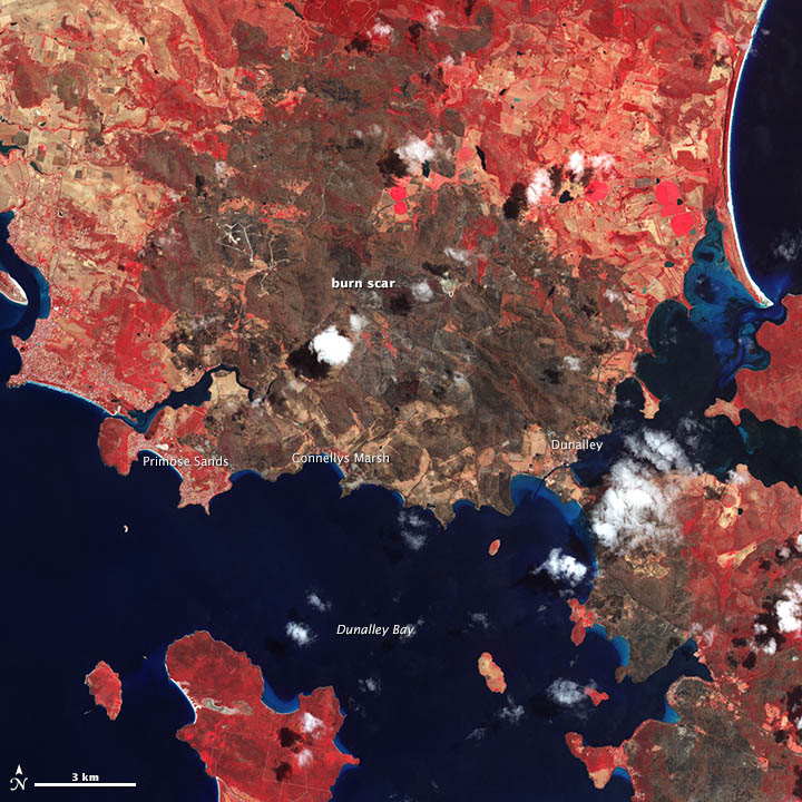
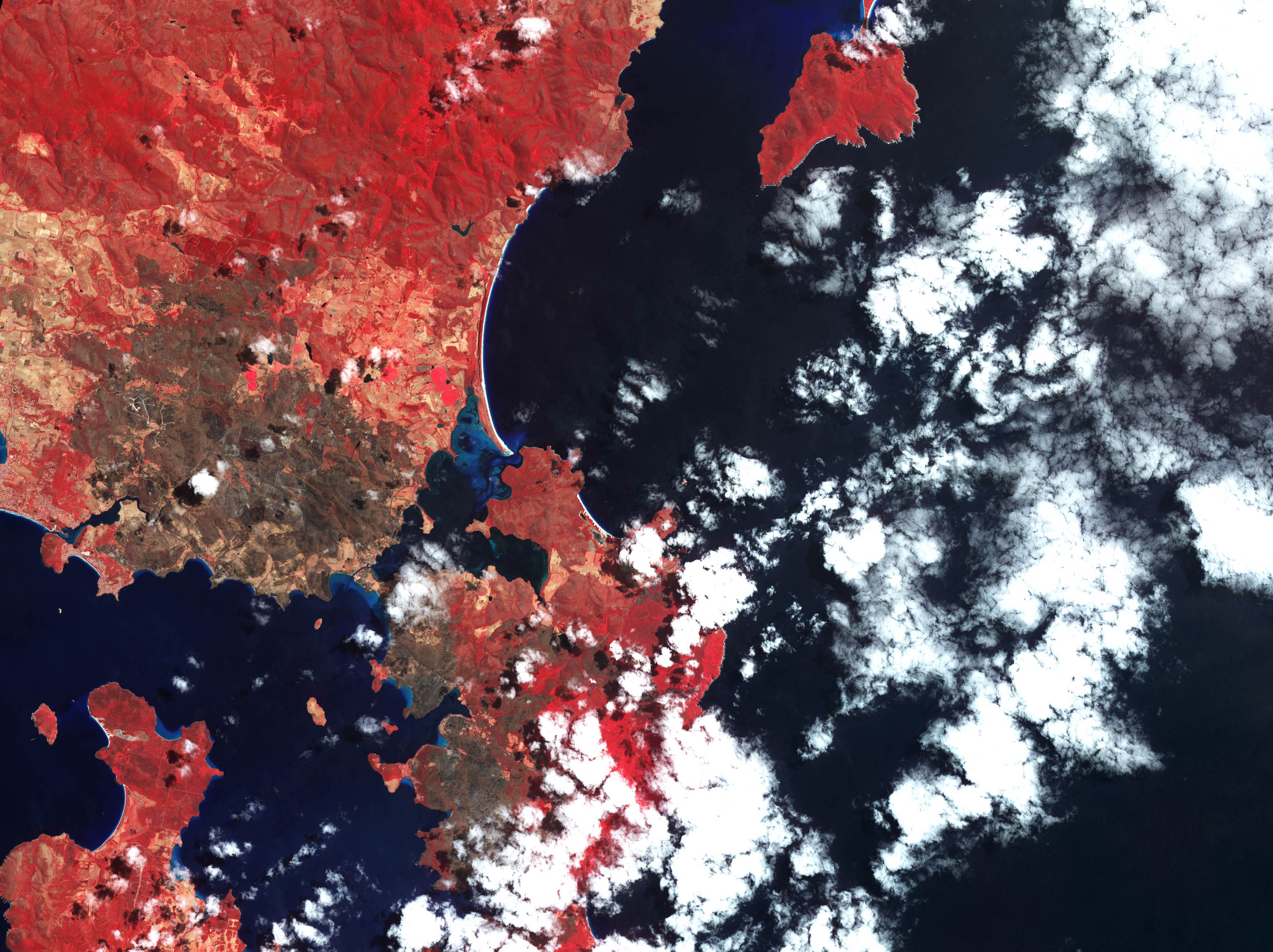
Satellite imagery indicates that the 2013 Tasmanian bushfires did not burn Smooth Island.[52][53]
Previous owners
| Date purchased | Buy price | Date sold | Sell price | Owner name | Owner information | References |
|---|---|---|---|---|---|---|
| 21 April 1864 | £155 | 26 July 1878 | £400 | Thomas Gabriel Read | Famous Tasmanian gold prospector; he started the Otago Gold Rush.[54] He was born in Tasmania, the second son of Captain G. F. Read. Between 1861 and 1864 he was prospecting for gold in New Zealand. He received a reward of £1,000 and had returned to Tasmania in 1864, where he purchased Smooth Island and was said to have taken up farming by 1865. He married Amelia Mitchell on 2 January 1869.[55] He was admitted to a psychiatric hospital from 1887 until he died in 1894. | Biography[22] |
| - | - | - | - | Edward Pillinger | Edward married Amelia Little on 5 September 1857.[56] Mr Pillinger claimed to live on the island 20 August 1867. Edward and Amelia had a daughter 22 July 1874 (unknown name).[57] Edward was engaged in a financial dispute with Thomas Gabriel Read, the island's previous owner.[58] He was found dead in Mr Neil Lewis's run in Milford, Cambridge on 8 June 1878, in an advanced state of decomposition. He was 50 years old. An inquest returned an open verdict, however given a partly full bottle of Strychnine was found near the corpse, Strychnine poisoning was presumed to be the cause of death.[59] Mr Pillinger's wife, Amelia, died on Smooth Island on 1 October 1876 after a 'short and painful' illness.[60] Mr Pillinger sold the island in 1877-1878.[61] Edward Pillinger was the brother-in-law of Mr Vimpany. | Circumstances of death[59][62] |
| 26 July 1878 | £400 | 15 November 1880 (court order)[63][64] | - | Captain James Quested | Convict who was shipped from London to Tasmania during 1827 on the ship Governor Ready for the charge of aiding and abetting smugglers.[65] Later became a master mariner. Criminal.[66] Lived on Smooth Island with his wife (cousin, convict/criminal). Forced to sell the island via public auction on 15 November 1880 due to court order (Daly V. Quested) dated 25 October 1880.[64] The Daly and Quested families had a long, bitter history of petty conflict.[67] Quested died 30 March 1892: Buried at Church of England Section B No.47 at Cornelian Bay Cemetery, Hobart | Further information[68] |
| - | - | 1919 | - | Captain de Hoghton | Married Julia Georgina Read 29 March 1881.[69] He died 29 June 1920 at age 74 at his residence in Cleveland, Holebrook-place. Capt de Hoghton had attempted to sell the island between 9 December 1893 and 12 January 1895. However, it may not have actually sold during this period. He may have ended up keeping the island until just prior to his death, in line with the clearing sale of 1919 listed below. Advertisements for a livestock clearing sale occurred on 29 October 1919, after the island was reportedly sold.[70] | Orbituaries[71] |
| - | - | 1927 | - | Samuel Nicholas Wellard | He publicly expressed opinions on the Ralph Bay Neck Canal.[72] One of his family members died near Smooth Island.[73] Wellard was said to have given up the lease of Smooth Island on 16 October 1901.[74] | - |
| 1929[17] | - | 2013 | - | Barclay Gray | Barclay commissioned a survey for Phosphate Rock on the island in 1941 | [75] |
References
- ↑ Laurent Dousset. "Detailed record of the Oyster Bay Tribe". ausanthrop.net. Retrieved 22 March 2015.
- ↑ Super User. "Local History". tasman.tas.gov.au. Retrieved 22 March 2015.
- 1 2 "Port Arthur, TAS - Aussie Towns". Aussie Towns. Retrieved 22 March 2015.
- 1 2 "The Discovery of Tasmania". google.com.au.
- ↑ Egli, J. J. (Johann Jacob), 1825-1896. "Nomina geographica Versuch einer allgemeinen ... . - Full View - HathiTrust Digital Library - HathiTrust Digital Library". hathitrust.org. Retrieved 22 March 2015.
- ↑ http://gutenberg.net.au/ebooks/e00049-images/flinders1-atlas3.jpg
- 1 2 Flinders M (1965). "Observations on the Coasts of Van Diemen's Land, on Bass's Strait and Its Islands, and on Part of the Coasts of New South Wales: Intended to Accompany the Charts of the Late Discoveries in Those Countries". Gutenberg.net.au. Retrieved 11 January 2015.
- ↑ Observations on the Coasts of Van Diemen's Land, on Bass's Strait and Its ... – Matthew Flinders – Google Books. Books.google.com.au. Retrieved 11 January 2015.
- 1 2 Flinders M (1814). A Voyage to Terra Australia, Undertaken for the Purpose of Completing the Discovery of that Vast Country, and Prosecuted in the Years 1801, 1802, and 1803, in His Majesty's Ship the Investigator and Subsequently in the Armed Vessel Porpoise and Cumberland Schooner. Books.google.com.au. Retrieved 11 January 2015.
- ↑ http://arrow.latrobe.edu.au/store/3/4/6/1/1/public/B13858427S3V1Series%203.%20Volume%20I.%20Complete%20work.pdf
- ↑ Walker JB (1914). "Tasmania RSo: Early Tasmania: papers read before the Royal Society of Tasmania during the years 1888 to 1899". J. Vail.
- ↑ "The Mercury". Mercurynie.com.au. Retrieved 11 January 2015.
- ↑ "LINC Tasmania catalogue • "0 @@ Chart of Van Diemen's Land from the best authorities and from actual surveys and measurements" by z @@ Scott, Thomas, 1800-1855". LINC Tasmania catalogue. Retrieved 11 April 2015.
- ↑ "The Hobart Town Courier (Tas. : 1827 – 1839)". Trove.nla.gov.au. Retrieved 11 April 2015.
- ↑ "01 Oct 1839 - Advertising". nla.gov.au. Retrieved 11 April 2015.
- ↑ "The journal of Charles O'Hara Booth". google.com.au.
- 1 2 "Living in History". google.com.au.
- ↑ "Garden Island, Norfolk Bay". Trove.nla.gov.au. Retrieved 11 January 2015.
Lot 2879, 145 acres 1 rood 30 perches, comprising an island known as Garden Island, situate in Norfolk Bay and King George's Sound. Upset price £227
- ↑ "23 April 1864: Government Land Sale". Trove.nla.gov.au. Retrieved 28 December 2014.
- ↑ "Sorell tasmania 1866 residents". ancestry.com. Retrieved 22 March 2015.
- ↑ "17 Nov 1894 - Family Notices". nla.gov.au.
- 1 2 "Read, Thomas Gabriel – Biography – Te Ara Encyclopedia of New Zealand". teara.govt.nz.
- ↑ "Illustrated Australian News for Home Readers (Melbourne, Vic. : 1867 – 1875)". Trove.nla.gov.au. Retrieved 11 January 2015.
- ↑ "he Cornwall Chronicle (Launceston, Tasmania : 1835 – 1880)". Trove.nla.gov.au. Retrieved 11 January 2015.
- ↑ "30 Jul 1878 - COMMERCIAL INTELLIGENCE. The Mercury Office, Mon...". nla.gov.au. Retrieved 22 March 2015.
- ↑ "The Mercury (Hobart, Tas. : 1860 – 1954)". Trove.nla.gov.au. Retrieved 11 January 2015.
- ↑ "The Mercury (Hobart, Tas. : 1860 – 1954)". Trove.nla.gov.au. Retrieved 11 January 2015.
- ↑ "The Mercury (Hobart, Tas. : 1860 – 1954)". Trove.nla.gov.au. Retrieved 11 January 2015.
- ↑ "The Mercury (Hobart, Tas. : 1860 – 1954)". Trove.nla.gov.au. Retrieved 11 January 2015.
- ↑ "The Mercury (Hobart, Tas. : 1860 – 1954)". Trove.nla.gov.au. Retrieved 11 January 2015.
- ↑ "GARDEN ISLAND, Norfolk Bay, for private sale. Apply to CAPTAIN DE HOGHTON, "Winton," Brighton". Trove.nla.gov.au. Retrieved 11 January 2015.
- ↑ "The Mercury (Hobart, Tas. : 1860 – 1954)". Trove.nla.gov.au. Retrieved 11 January 2015.
- ↑ "The Sydney Morning Herald (NSW : 1842 – 1954)". Trove.nla.gov.au. Retrieved 11 January 2015.
- ↑ "The Sydney Morning Herald (NSW : 1842 – 1954)". Trove.nla.gov.au. Retrieved 11 January 2015.
- ↑ "04 Jul 1900 - EAST BAY NECK. To the Editor of "The Mercury."". nla.gov.au. Retrieved 11 April 2015.
- ↑ "Nelson Evening Mail — 24 July 1909 — LOCAL & GENERAL NEWS". Paperspast.natlib.govt.nz. Retrieved 11 January 2015.
- ↑ "The Mercury (Hobart, Tas. : 1860 – 1954)". Trove.nla.gov.au. Retrieved 11 January 2015.
- ↑ "A FISHING BOAT FATALITY. - Daily Telegraph (Launceston, Tas. : 1883 - 1928) - 16 Nov 1903".
- ↑ "The Mercury (Hobart, Tas. : 1860 – 1954)". Trove.nla.gov.au. Retrieved 11 January 2015.
- ↑ "02 Sep 1914 - THE NORFOLK BAY TRAGEDY. A MYSTERIOUS OCCURRENCE...". nla.gov.au. Retrieved 6 April 2015.
- ↑ "The Mercury (Hobart, Tas. : 1860 – 1954)". Trove.nla.gov.au. Retrieved 11 January 2015.
- ↑ "The Mercury (Hobart, Tas. : 1860 – 1954)". Trove.nla.gov.au. Retrieved 11 January 2015.
- ↑ "15 Oct 1919 - Advertising". nla.gov.au. Retrieved 22 March 2015.
- 1 2 "Lot 1 Norfolk Bay, Dunalley TAS 7177". Homebound.com.au. Retrieved 10 January 2015.
- ↑ "Tasmanian Birds". google.com.au.
- ↑ "Introduced birds of the world". google.com.au.
- ↑ "The Mercury (Hobart, Tas. : 1860 – 1954)". Trove.nla.gov.au. Retrieved 11 January 2015.
- ↑ "08 Nov 1946 - ENGINES NOT TO BE SEALED IN OCEAN RACE Hobart Re...". nla.gov.au. Retrieved 22 March 2015.
- ↑ "09 Apr 1946 - Advertising". nla.gov.au. Retrieved 11 April 2015.
- ↑ "533 SCHEME AMENDMENT- BOOMER JETTY ROAD, BOOMER BAY.docx". Google Docs. Retrieved 22 March 2015.
- ↑ http://reit.com.au/wp-content/uploads/SPDR-NOV13.pdf
- ↑ http://eoimages.gsfc.nasa.gov/images/imagerecords/80000/80252/tasmania_ast_2013014.jpg
- ↑ http://eoimages.gsfc.nasa.gov/images/imagerecords/80000/80252/tasmania_ast_2013014_lrg2.jpg
- ↑ "Full text of "A Statistical Account of the Seven Colonies of Australasia, 1901-1902"". archive.org.
- ↑ "Mitchell, Amelia". sirsidynix.net.au.
- ↑ "Pillenger, Edward". sirsidynix.net.au.
- ↑ "Pillenger, Given Name Not Recorded". sirsidynix.net.au.
- ↑ "21 Aug 1867 - Advertising". nla.gov.au.
- 1 2 "02 Aug 1878 - Advertising". nla.gov.au.
- ↑ "30 Oct 1876 - Family Notices". nla.gov.au.
- ↑ "11 Jun 1878 - THE MERCURY. TUESDAY MORNING, JUNE 11, 1878.". nla.gov.au.
- ↑ "11 Jun 1878 - THE MERCURY. TUESDAY MORNING, JUNE 11, 1878.". nla.gov.au.
- ↑ "26 Oct 1880 - Advertising". nla.gov.au.
- 1 2 "26 Oct 1880 - Advertising". nla.gov.au.
- ↑ "Archives Office of Tasmania digitised record". archives.tas.gov.au. C1 control character in
|title=at position 29 (help) - ↑ "12 Dec 1883 - SORELL. [From our own Correspondent.]". nla.gov.au.
- ↑ "16 Oct 1872 - LAW INTELLIGENCE. POLICE COURt. TUESDAY, OCTOBER...". nla.gov.au.
- ↑ http://researchtasmania.com.au/documents/biographies/MACK_Ann.pdf
- ↑ "De-hoghton, Thomas". sirsidynix.net.au.
- ↑ "07 Oct 1919 - Advertising". nla.gov.au.
- ↑ "02 Jul 1920 - Family Notices". nla.gov.au.
- ↑ "07 Sep 1912 - RALPH BAY NECK CANAL. To the Editor of "The Merc...". nla.gov.au.
- ↑ "28 Aug 1914 - LATE MR. C. WELLARD. To the Editor of "The Mercu...". nla.gov.au.
- ↑ "16 Oct 1901 - Advertising". nla.gov.au.
- ↑ http://www.mrt.tas.gov.au/mrtdoc/dominfo/download/UR1891_1969_151_152_OLD/UR1891-1969_151-152.pdf