Doughboy Island (Tasmania)
For other places with the same name, see Doughboy Island.
|
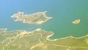
Doughboy Island (top right), taken from the south east. | |
 Doughboy Island Location of the Doughboy Island in Bass Strait | |
| Geography | |
|---|---|
| Location | Bass Strait |
| Coordinates | 40°20′24″S 148°03′00″E / 40.34000°S 148.05000°ECoordinates: 40°20′24″S 148°03′00″E / 40.34000°S 148.05000°E |
| Archipelago | Tin Kettle Group, part of the Furneaux Group |
| Area | 30 ha (74 acres) |
| Administration | |
|
Australia | |
| State | Tasmania |
The Doughboy Island, part of the Tin Kettle Group within the Furneaux Group, is a 30-hectare (74-acre) unpopulated mainly granite island, located in Bass Strait, lying west of the Flinders and Cape Barren islands, Tasmania, in south-eastern Australia.[1][2]
The island has been devastated by irresponsible farming practices and fire.
Fauna
Recorded breeding seabird and wader species are little penguin, Pacific gull and sooty oystercatcher. The metallic skink is present.[3]
See also
References
- ↑ "Doughboy Island (TAS)". Gazetteer of Australia online. Geoscience Australia, Australian Government.
- ↑ "Small Bass Strait Island Reserves. Draft Management Plan". Department of Primary Industries,Water and Environment, Tasmanian Government. October 2000. Retrieved 4 February 2012.
- ↑ Brothers, Nigel; Pemberton, David; Pryor, Helen; & Halley, Vanessa. (2001). Tasmania’s Offshore Islands: seabirds and other natural features. Tasmanian Museum and Art Gallery: Hobart. ISBN 0-7246-4816-X
This article is issued from Wikipedia - version of the 11/16/2016. The text is available under the Creative Commons Attribution/Share Alike but additional terms may apply for the media files.