Cape Raoul
Cape Raoul is situated at the southernmost part of the Tasman Peninsula, in south eastern Tasmania.
It forms the coastline of Raoul Bay, and is part of the Dolerite landscape of the Tasman National Park.
Notes from 1911
So named from D'Entrecasteaux's pilot. Flinders called it Basaltic Cape, but only prior to the publication of the maps of the French expedition. "In 1814 Flinders very honestly (writes Comte deFleurieu) replaces on his map the name of Raoull, stating that he gave up the name of Basaltic. This notwithstanding, Scott, Cross, and Arrowsmith chart it as Raoull or Basaltic.
.[1]
Gallery
 Dolerite columns of Cape Raoul.
 Columns at the tip of the cape.
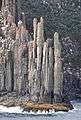 Tip of the cape from the sea.
 Tasman Island and Tasman Peninsula from Cape Raoul.
References
- ↑ "TASMANIAN NOMENCLATURE.". The Mercury (Hobart, Tas. : 1860 - 1954). Hobart, Tas.: National Library of Australia. 16 September 1911. p. 10. Retrieved 1 June 2015. ( TASMANIAN NOMENCLATURE. The Place-Names of the State. A Record Of Origins and Dates.Compiled by "Nomen." - section on Cape Raoul)
Coordinates: 43°13′S 147°47′E / 43.22°S 147.79°E
South Eastern region of Tasmania, Australia | |||||||
|---|---|---|---|---|---|---|---|
| Governance former | |||||||
| Mountains |
| ||||||
| Protected areas, parks and reserves |
| ||||||
| Rivers | |||||||
| Harbours, bays, inlets and estuaries | |||||||
| Transport | |||||||
| Landmarks |
| ||||||
| Islands |
| ||||||
| Books and newspapers | |||||||
| Bioregions | |||||||
| |||||||
This article is issued from Wikipedia - version of the 2/16/2016. The text is available under the Creative Commons Attribution/Share Alike but additional terms may apply for the media files.