Sin el Fil
| Sinn al-Fīl سن الفيل | |
|---|---|
| City | |
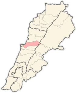
 Sinn al-Fīl Location within Lebanon | |
| Coordinates: 33°52′N 35°32′E / 33.867°N 35.533°ECoordinates: 33°52′N 35°32′E / 33.867°N 35.533°E | |
| Country |
|
| Governorate | Mount Lebanon Governorate |
| District | Matn District |
| Government | |
| • Time Zone | GMT +2 (UTC) |
| • – Summer (DST) | +3 (UTC) |
| • Area Code(s) | (+961) 1 |
| Time zone | EET (UTC+2) |
| • Summer (DST) | EEST (UTC+3) |
| Dialing code | +961 |
Sin el-Fil (Arabic: سنّ الفيل / ALA-LC: Sinn al-Fīl) is a suburb east of Beirut in the Matn District of the Mount Lebanon Governorate, Lebanon.
Etymology
The name literally means 'ivory': "tooth" (sinn) of "the elephant" (al-fīl). Being geographically closer to the ancient city of Antioch and far remote from natural elephant habitat, it is believed that the town name may have been a derogation of Saint Theophilus of Antioch.
Geography
With a rich red soil and moderate precipitation (but available ground water irrigation) the agricultural land of Sin el Fil in the early 20th century sprawled into a densely populated suburb. The natural landscape of the late century was dominated by stone pine. The Beirut River runs west of Sin el Fil and separates the town from the capital, Beirut.
Demographics
Family names from this village are: Abdullah, Antoun, Ayoub, Barakat, Bazzi, Berberian, Chadessi, Chidiac, El-Hage, El-Hakem, Hamdan, Hennessi, Hijazi, Karam, Kahalé, Khoury, Lahood, Mannah, Mansour, Massaad, Saad, Sahyoun, Saadi,Amhaz, Chaoul
Archaeology
Collections of archaeological material from this limestone "hogsback" were made from the gullies to the south of the main road on the slopes of forested hills. The recovery areas were described as "ravines sinueuses" by Raoul Describes after making a collection in 1921.[1] Other Jesuits who made collections from the area included Godefroy Zumoffen in 1908, Paul Bovier-Lapierre and Auguste Bergy as well as Mouterde, Gigues, Lorraine Copeland and Peter Wescombe. E. Passemard suggested that two of the trihedral pieces collected by Paul Bovier-Lapierre were Chalossian.[2][3] Describes published some of the material as Acheulean but the bulk of the material was very mixed including lots of indeterminate Neolithic pieces including Trihedral Neolithic and Heavy Neolithic forms. There was also a Roman occupation on the flat fields above the slopes. Some archaeological material from Sin el Fil is in the National Museum of Beirut and the Museum of Lebanese Prehistory.[4]
Twin towns — Sister cities
References and footnotes
- ↑ Describes, Raoul., Quelques ateliers paléolithiques des environs de Beyrouth, Mélanges de l'Université Saint-Joseph: Volume VII, 1921.
- ↑ Passemard, E., "Syria", Volume 8, 1927
- ↑ E. Passemard , P. Dubalen , A. Vayson de Pradenne , R. Neuville, La Question Chalossienne, Bulletin de la Société préhistorique française, 1931, Volume 28, Issue 6, pp. 289–293
- ↑ Lorraine Copeland; P. Wescombe (1965). Inventory of Stone-Age sites in Lebanon, p. 136-137. Imprimerie Catholique. Retrieved 21 July 2011.
- ↑ "Sin el fil Official Web Site". City of Sin el fil. Retrieved 2012-03-29.
External links
- Sinn El Fil, Localiban
- Municipality of Sin el Fil (Arabic)
Capital: Jdeideh | ||
| Towns and villages |
|  |
| Notable landmarks | ||
| Notable touristic sites | ||