Hebbariye
| Hebbariye هبّارية Hebbariya, Hebbariyeh, Hebariya | |
|---|---|
| Village, Municipality | |
|
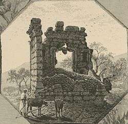
Hebbariye, in the 1880s[2] | |
| Country |
|
| Governorate | Nabatieh Governorate |
| District | Hasbaya District |
| Population (1970) | |
| • Total | 1,800[3] |
 Shown within Lebanon | |
| Alternate name | Habbariya, Habbariyeh, Habariya |
|---|---|
| Location | 116 kilometres (72 mi) east of Beirut |
| Region | Hasbaya |
| Coordinates | 33°22′03″N 35°41′39″E / 33.3675°N 35.694167°E |
| History | |
| Cultures | Roman |
| Site notes | |
| Condition | Ruins |
| Public access | Yes |
Hebbariye, Hebbariyeh, Hebbariya or Hebariya (Arabic: هبّارية) is a village and municipality situated in the Hasbaya District of the Nabatieh Governorate in Lebanon.[4] It is located on the southwestern slopes of Mount Hermon near the Syrian border, northeast of Rachaya Al Foukhar and is positioned amongst orchards of apricot trees.[4]
The village sits ca. 750 metres (2,460 ft) above sea level and the small population is predominantly Sunni Muslim.[5]
Roman temple
There is a Roman temple near to the village, opposite the Wadi Shib'a which is the most southern of the Temples of Mount Hermon, a group defined by George Taylor as being south of the main road to Damascus on the west of Mount Hermon, including the Wadi al-Taym area.[6][7][8] It has been classified as an Antae temple with an eastern portal that faces Mount Hermon, aligned "as if to catch the first beams of the morning sun rising over Hermon."[7][9] The temple has a large basement chamber underneath the cella floors that is thought to have been used for burial. The room is only accessible from the outside of the building.[10] The temple was surveyed in the summer of 1852 by Edward Robinson who noted several large blocks with one measuring 2.75 feet (0.84 m) by 15 feet (4.6 m). He measured the dimensions of the temple to be 58 feet (18 m) long by 31 feet (9.4 m) wide with 6 feet (1.8 m) thick walls around 32 feet (9.8 m) high. The capitals appeared to be of an Ionic style.[6][7] At the entrance doorway, there are two tiers of niches with some engraved writing beneath the upper set.[9]
References
- ↑ Wilson, ca 1881, vol 2, p. 128
- ↑ Wilson, ca 1881, vol 2, p. 128
- ↑ Nah- und Mittelost-Verein; Deutsches Orient-Institut (1970). Orient. Deutsches Orient-Institut. Retrieved 17 September 2012.
- 1 2 Robert Boulanger (1955). Lebanon. Hachette. Retrieved 17 September 2012.
- ↑ NOW Lebanon, Being infamous: A man who worked with the Israeli army asks for his pension, Ana Maria Luca , February 20, 2010.
- 1 2 Robinson and Smith, 1856, pp. 416-418
- 1 2 3 Wilson, ca 1881, vol 2, pp. 127-128
- ↑ Daniel M. Krencker; Willy Zschietzschmann (1938). Römische Tempel in Syrien: nach Aufnahmen und Untersuchungen von Mitgliedern der Deutschen Baalbekexpedition 1901-1904, Otto Puchstein, Bruno Schulz, Daniel Krencker [u.a.] ... W. de Gruyter & Co. Retrieved 17 September 2012.
- 1 2 George Taylor (1971). The Roman temples of Lebanon: a pictorial guide. Les temples romains au Liban; guide illustré. Dar el-Machreq Publishers. Retrieved 17 September 2012.
- ↑ Kevin Butcher (19 February 2004). Roman Syria and the Near East. Getty Publications. pp. 359–. ISBN 978-0-89236-715-3. Retrieved 17 September 2012.
Bibliography
- Robinson, Edward; Smith, Eli (1856). Later Biblical Researches in Palestine and adjacent regions: A Journal of Travels in the year 1852. London: John Murray.
- Wilson, Charles Williams, ed. (c. 1881). Picturesque Palestine, Sinai and Egypt. 2. New York: D. Appleton.
External links
- Photos of Hebbariye and the Roman temple on panoramio.com
- 3D Google Earth map of Hebbariye on www.gmap3d.com
- Hebbariya on wikimapia
- Hebbariyeh on www.localiban.org
- Image of the temple at Hebbariye from "Palestine 1881 Ruins Temple Hebbariyeh Mount Hermon", A page taken from Picturesque Palestine, Sinai and Egypt. Edited by Charles Wilson, 1881, p. 126. on Amazon.com
- Full text of Picturesque Palestine, Sinai and Egypt. Edited by Charles Wilson, 1881.
Capital: Hasbaya | ||
| Towns and villages | 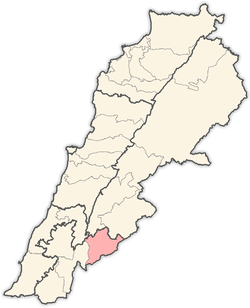 | |
| Other | ||