Silverthorne, Colorado
| Silverthorne, Colorado | |
|---|---|
| Town | |
|
Silverthorne seen from Ptarmigan Peak. In the background Buffalo Mountain is on the left, while Red Mountain and Mount Silverthorne are located adjacent to each other to the right. | |
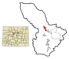 Location in Summit County and the state of Colorado | |
| Coordinates: 39°38′18″N 106°4′35″W / 39.63833°N 106.07639°WCoordinates: 39°38′18″N 106°4′35″W / 39.63833°N 106.07639°W | |
| Country |
|
| State |
|
| County[1] | Summit County |
| Incorporated | September 5, 1967[2] |
| Government | |
| • Type | Home Rule Municipality[1] |
| Area | |
| • Total | 3.2 sq mi (8.3 km2) |
| • Land | 3.2 sq mi (8.2 km2) |
| • Water | 0 sq mi (0.1 km2) |
| Elevation[3] | 9,035 ft (2,754 m) |
| Population (2010) | |
| • Total | 3,887 |
| Time zone | Mountain (MST) (UTC-7) |
| • Summer (DST) | MDT (UTC-6) |
| ZIP codes[4] | 80497 (Post-office box), 80498 |
| Area code(s) | 970 |
| FIPS code | 08-70525 |
| GNIS feature ID | 0204668 |
| Website | Town of Silverthorne |

Silverthorne is a Home Rule Municipality that is the second most populous town in Summit County, Colorado. According to 2010 Census, the population of the city is 3,887.[5]
History
The town was named for Judge Marshall Silverthorn who served as the judge of the miner's court in Breckenridge. The judge first came to town as a prospector and claimed a section of the Blue River in 1881. After patenting his claim in April 1882, he was disappointed to find the gold to be sparse and the claim a poor bet. The land passed to his daughters on his death in 1887 and was then sold several times to various mining companies. In 1953, Clayton Hill bought the property and subdivided it for homes and stores. [6]
Silverthorne served as a makeshift camp for workers during the construction of the Dillon Reservoir from 1961-1963, and later as a stop along Interstate 70. It was eventually incorporated on April 5, 1967.[2]
The city has expanded several times since incorporation by annexation.
Geography
Silverthorne is located at 39°38′18″N 106°04′35″W / 39.638391°N 106.076505°W,[7] at 8,730 feet above sea level (2661 meters). The town is situated between the Gore Range to the west and the Continental Divide to the east. The two most visible mountains are Buffalo and Red Mountains. Also surrounding the valley are Ptarmigan, Tenderfoot, and Ten Mile Peaks.
According to the United States Census Bureau, the town has a total area of 3.2 square miles (8.3 km2), of which, 3.2 square miles (8.3 km2) of it is land and 0.04 square miles (0.10 km2) of it (0.94%) is water.
Demographics
| Historical population | |||
|---|---|---|---|
| Census | Pop. | %± | |
| 1970 | 400 | — | |
| 1980 | 989 | 147.3% | |
| 1990 | 1,768 | 78.8% | |
| 2000 | 3,196 | 80.8% | |
| 2010 | 3,887 | 21.6% | |
| Est. 2015 | 4,418 | [8] | 13.7% |
As of the census[10] of 2000, there were 3,196 people, 1,103 households, and 736 families residing in the town. The population density was 1,009.1 people per square mile (389.3/km²). There were 1,582 housing units at an average density of 499.5 per square mile (192.7/km²). The racial makeup of the town was 82.17% White, 1.00% African American, 0.66% Native American, 0.75% Asian, 0.28% Pacific Islander, 11.17% from other races, and 3.97% from two or more races. Hispanic or Latino of any race were 23.50% of the population.
There were 1,103 households out of which 36.2% had children under the age of 18 living with them, 53.0% were married couples living together, 6.7% had a female householder with no husband present, and 33.2% were non-families. 13.8% of all households were made up of individuals and 0.5% had someone living alone who was 65 years of age or older. The average household size was 2.90 and the average family size was 3.14.
In the town the population was spread out with 23.1% under the age of 18, 14.8% from 18 to 24, 42.3% from 25 to 44, 17.8% from 45 to 64, and 2.0% who were 65 years of age or older. The median age was 30 years. For every 100 females there were 130.4 males. For every 100 females age 18 and over, there were 140.7 males.
The median income for a household in the town was $58,839, and the median income for a family was $61,715. Males had a median income of $31,983 versus $27,172 for females. The per capita income for the town was $24,271. About 2.9% of families and 7.2% of the population were below the poverty threshold, including 6.1% of those under age 18 and none of those age 65 or over.
Notable people
Notable individuals who were born in or have lived in Silverthorne include:
- Dan Gibbs (1976- ), Colorado state legislator[11]
- Mike Potekhen (1979- ), race car driver[12]
See also
References
- 1 2 "Active Colorado Municipalities". State of Colorado, Department of Local Affairs. Retrieved 2007-09-01.
- 1 2 "Colorado Municipal Incorporations". State of Colorado, Department of Personnel & Administration, Colorado State Archives. 2004-12-01. Retrieved 2007-09-02.
- ↑ "US Board on Geographic Names". United States Geological Survey. 2007-10-25. Retrieved 2008-01-31.
- ↑ "ZIP Code Lookup" (JavaScript/HTML). United States Postal Service. Retrieved 2008-01-02.
- ↑ "Annual Estimates of the Population for All Incorporated Places in Colorado" (CSV). 2005 Population Estimates. U.S. Census Bureau, Population Division. June 21, 2006. Retrieved November 17, 2006.
- ↑
- ↑ "US Gazetteer files: 2010, 2000, and 1990". United States Census Bureau. 2011-02-12. Retrieved 2011-04-23.
- ↑ "Annual Estimates of the Resident Population for Incorporated Places: April 1, 2010 to July 1, 2015". Retrieved July 2, 2016.
- ↑ "Census of Population and Housing". Census.gov. Retrieved June 4, 2015.
- ↑ "American FactFinder". United States Census Bureau. Retrieved 2008-01-31.
- ↑ "Dan Gibbs' Biography". Vote Smart. Retrieved 2016-06-17.
- ↑ "Mike Potekhen". ChampCarStats.com. Retrieved 2016-06-17.
External links
| Wikimedia Commons has media related to Silverthorne, Colorado. |
- Town of Silverthorne website
- CDOT map of the Town of Silverthorne
- Lake Dillon Fire Protection District
- Summit County
- City of Breckenridge
- City of Dillon
- City of Frisco
- Colorado Department of Transportation
- Silverthorne Lodging and Vacation Rentals
Municipalities and communities of Summit County, Colorado, United States | ||
|---|---|---|
| Towns |  | |
| CDPs | ||
| Ghost towns | ||
