Scalpay, Outer Hebrides
| Gaelic name | Sgalpaigh na Hearadh/Sgalpaigh |
|---|---|
| Norse name | Skalprøy[1] |
| Meaning of name | scallop island or ship Island |
| Location | |
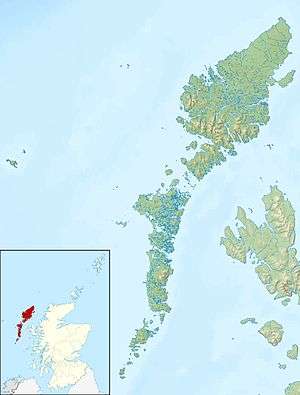 Scalpay Scalpay shown within Outer Hebrides | |
| OS grid reference | NG214965 |
| Physical geography | |
| Island group | Lewis and Harris |
| Area | 653 ha (2.5 sq mi) |
| Area rank | 66 [2] |
| Highest elevation | Beinn Scorabhaig 104 m (341 ft) |
| Administration | |
| Sovereign state | United Kingdom |
| Country | Scotland |
| Council area | Comhairle nan Eilean Siar |
| Demographics | |
| Population | 291[3] |
| Population rank | 26 [2] |
| Pop. density | 44.5 people/km2[1][3] |
| Largest settlement | An Acarsaid a Tuath (North Harbour) |
| References | [1][4][5] |
Scalpay (Scottish Gaelic: Sgalpaigh or Sgalpaigh na Hearadh i.e. "Scalpay of Harris" to distinguish it from Scalpay off Skye) is an island in the Outer Hebrides of Scotland.
Geography
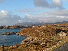
Scalpay is around 4 kilometres (2.5 miles) long and rises to a height of 104 metres (341 feet) at Beinn Scorabhaig. The area of Scalpay is 653 hectares (2.52 sq mi). The main settlement on the island is at the north, near the bridge, clustered around An Acairseid a Tuath (North Harbour).
The island is peppered with small lochans. The largest of these is Loch an Duin (Loch of the Fort) which has a tiny island in it, with the remains of the fort still visible. Eilean Glas, a tiny peninsula on Scalpay's eastern shore, is home to the first lighthouse to be built in the Outer Hebrides.
Scalpay's nearest neighbour, Harris, is just 300 metres (980 feet) away across the narrows of Caolas Scalpaigh. In 1997, a bridge from Harris to Scalpay was built,[6] replacing a ferry service.
Etymology
Mac an Tàilleir (2003) suggests the name derives from "ship island" from the Norse.[7] However, Haswell-Smith states that the Old Norse name was Skalprøy, meaning "scallop island".[1]
Religion
The vast majority of the locals in Scalpay are Protestants. The island is home to two Presbyterian churches, the Free Church of Scotland and the Free Church of Scotland (Continuing). Like most places in the Outer Hebrides, Sunday is a day that locals use to rest from work and attend church. Respect for the Sabbath is appreciated by the islanders and they warmly welcome all visitors to meet with them during the services.
Demographics
In 2001, the island had 322 people, whose main employment was fish farming and prawn fishing. By 2011 the population had declined by 9% to 291[3] whilst during the same period Scottish island populations as a whole grew by 4% to 103,702.[8]
Scalpay is home to many Gaelic singers and psalm presenters. The island used to have more than 10 shops over 30 years ago but due to lack of people and work, the last shop closed in 2007. There also used to be a salmon factory, which was a major local employer from 2001 until its closure in 2005. In the spring of 2009, local newspapers reported that the factory was to reopen as a net washing facility to support the local fish farming industry. In 2012, the Scalpay community bought and opened a community shop/café, Buth Scalpaigh.[9]
Photographer Marco Secchi lived on Scalpay for few years between 2002-2008 and documented life and landscape of the Outer Hebrides.
In 2011 the island's owner, Fred Taylor, announced that he proposed handing over the land to the local population. One proposal was that the island would be owned by a local development trust; under another proposal it would form part of the larger North Harris Trust, itself community owned.[10] Islanders voted to accept the gift and assume community ownership of the island. They will go into partnership with the North Harris Community Trust to run the island.[11]
See also
Footnotes
- 1 2 3 4 Haswell-Smith, Hamish (2004). The Scottish Islands. Edinburgh: Canongate. ISBN 978-1-84195-454-7.
- 1 2 Area and population ranks: there are c. 300 islands over 20 ha in extent and 93 permanently inhabited islands were listed in the 2011 census.
- 1 2 3 National Records of Scotland (15 August 2013) (pdf) Statistical Bulletin: 2011 Census: First Results on Population and Household Estimates for Scotland - Release 1C (Part Two). "Appendix 2: Population and households on Scotland’s inhabited islands". Retrieved 17 August 2013.
- ↑ Ordnance Survey. Get-a-map (Map). 1:25,000. Leisure. Ordinance Survey. Retrieved 21 August 2013.
- ↑ Mac an Tàilleir, Iain (2003) Ainmean-àite/Placenames. (pdf) Pàrlamaid na h-Alba. Retrieved 26 August 2012.
- ↑ "Scalpay Bridge". Comhairle nan Eilean Siar. Retrieved 23 Jan 2012.
- ↑ Mac an Tàilleir p. 103
- ↑ "Scotland's 2011 census: Island living on the rise". BBC News. Retrieved 18 August 2013.
- ↑ "Scalpay community shop opening". Stornoway Gazette. 9 May 2012. Retrieved 2 June 2013.
- ↑ "Islanders offered home as a 'free gift' from London owner". Senscot, quoting the Press and Journal. 18 Feb 2011. Retrieved 11 Mar 2011.
- ↑ "Scalpay islanders vote in favour of takeover". BBC News. 6 November 2012. Retrieved 2 June 2013.
Coordinates: 57°52′13″N 6°41′33″W / 57.8703°N 6.6924°W
| Inhabited islands | ||
|---|---|---|
| Other islands | ||
| Settlements |
| |
| Districts | ||
| Geographical features | ||
| Historical sites | ||
Inhabited islands of the Hebrides | ||
|---|---|---|
| Inner Hebrides | 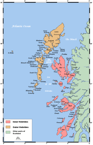 | |
| Outer Hebrides | ||
|  | ||||||||||||||||||||||||||||
|
| |||||||||||||||||||||||||||||
| |||||||||||||||||||||||||||||
| |||||||||||||||||||||||||||||
| |||||||||||||||||||||||||||||
| |||||||||||||||||||||||||||||
| |||||||||||||||||||||||||||||
| |||||||||||||||||||||||||||||