South Uist
| Gaelic name | Uibhist a Deas |
|---|---|
| Pronunciation | [ˈɯ.ɪʃtʲ ə tʲes̪] |
| Meaning of name | Pre-Gaelic and unknown[1] |
| Location | |
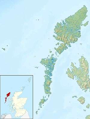 South Uist South Uist shown within the Outer Hebrides | |
| OS grid reference | NF786343 |
| Physical geography | |
| Island group | Uists & Barra |
| Area | 32,026 hectares (124 sq mi) |
| Area rank | 9 [2] |
| Highest elevation | Beinn Mhòr 620 metres (2,034 ft) |
| Administration | |
| Sovereign state | United Kingdom |
| Country | Scotland |
| Council area | Na h-Eileanan Siar |
| Demographics | |
| Population | 1,754[3] |
| Population rank | 9 [2] |
| Pop. density | 5.5 people/km2[3][4] |
| Largest settlement | Lochboisdale |
| References | [4][5][6][7] |
South Uist (Scottish Gaelic: Uibhist a Deas) is an island of the Outer Hebrides in Scotland. In the 2011 census it had a usually resident population of 1,754, a fall of 64 since 2001.[8] There is a nature reserve and a number of sites of archaeological interest, including the only location in Great Britain where prehistoric mummies have been found. The population is about 90% Roman Catholic. The island, in common with the rest of the Hebrides, is one of the last remaining strongholds of the Gaelic language in Scotland. In 2006 South Uist, and neighbouring Benbecula and Eriskay were involved in Scotland's biggest community land buyout to date. In the north west there is a missile testing range. Its inhabitants are known in Gaelic as "Deasaich" (Southerners).
Gaelic
According to the 2011 Census, there are 1,888 Gaelic speakers (60%) on South Uist and Benbecula.[9]
Geography and geology
The west is machair (fertile low-lying coastal plain) with a continuous sandy beach whilst the east coast is mountainous with the peaks of Beinn Mhòr 620 metres (2,034 ft) and Hecla 606 metres (1,988 ft). The main village on the island is Lochboisdale (Loch Baghasdail), from which ferries sail to Oban on the mainland and to Castlebay (Bàgh a' Chaisteil) on Barra. The island is also linked to Eriskay and Benbecula by causeways. Smaller settlements include Daliburgh (Dalabrog), Howmore (Tobha Mòr) and Ludag.
South Uist has a bedrock of Lewisian Gneiss,[10][11] high grade regional metamorphism dating back to 2900 million years ago in the Archaean. Some show granulite facies metamorphism, but most are the slightly lower temperature amphibolite facies. These formed part of the Earth’s deep ancient crust, left here when the North Atlantic was formed. These are the oldest rocks in the British Isles today and they have been brought to the surface by tectonic movements. They now bear the scars of the last glaciation which has exposed them.
"South Uist Machair" on the west coast is one of 40 National Scenic Areas in Scotland.[12]
Etymology
Mac an Tàilleir (2003) suggests the derivation of Uist may be "corn island".[13] However, whilst noting that the vist ending would have been familiar to speakers of Old Norse as meaning "dwelling" Gammeltoft (2007) states the word is "of non- Gaelic origin" and that it reveals itself as one of a number of "foreign place-names having undergone adaptation in Old Norse".[1]
History
South Uist was clearly home to a thriving Neolithic community. The island is covered in archaeological sites including chambered tombs, Beaker sites, a Bronze Age hoard, roundhouses, brochs, cairns, ogham inscriptions, Viking settlements, medieval longhouses and post-medieval industry. Bornais on South Uist was the largest Viking settlement known in Scotland. After the Norse occupation, South Uist was held by the MacDonalds of Clan Ranald who made a good living from kelp harvesting owing to the demand for kelp around the turn of the 19th century.[14] At that time population of the island was around 7300. After the Napoleonic Wars however, competition from imported Barilla resulted in a collapse in the price for kelp and the chief of Clan Ranald found himself facing bankruptcy.[15] South Uist was sold to Lt. Colonel John Gordon of Cluny in 1837 and the fortunes of the island's tenants went downhill from that point. He initiated Highland Clearances to make way for sheep farming, supplanting the crofters with farmers from the Borders, who brought flocks of Blackface sheep. As a result, there was large scale emigration from the island. Over the years, the population of South Uist has fallen from a total of 5093 in 1841 to its present level of 2285.[16]
Lochboisdale became a major herring port later in the nineteenth century. The island is one of the last surviving strongholds of the Gaelic language in Scotland and the crofting industries of peat cutting and seaweed gathering are still an important part of everyday life.
Economy
Tourism is important to the island's economy and attractions include the Kildonan Museum housing the sixteenth century Clanranald Stone and the ruins of the house where Flora MacDonald was born.
South Uist is home to the Askernish Golf Course. The oldest course in the Outer Hebrides, Askernish was designed by Old Tom Morris, who also worked on the Old Course at St. Andrews. Morris had been commissioned by Lady Gordon Cathcart in 1891.[17] The Askernish course existed intact until the 1930s, but was partly destroyed to make way for a runway, abandoned, and ultimately lost. Its identity remained hidden for many years before its apparent discovery, a claim disputed by some locals.[18][19][20] Restoration of the course to Morris' original design was held up by disagreements with local crofters,[21][22] but after legal challenges were resolved in the courts, the course opened in August 2008.
The popular summer music school, Ceòlas, takes place on the island every year from the first Sunday of July in Daliburgh School. It is then followed by the local children's summer school, Fèis Tir a'Mhurain.
After a protracted campaign South Uist residents took control of the island on 30 November 2006 in Scotland's biggest community land buyout to date. The previous landowners, a sporting syndicate, sold the assets of the 92,000 acres (372.31 km2) estate for £4.5 million[23] to a Community Company known as Stòras Uibhist which was set up to purchase the land and to manage it in perpetuity.[24][25] The buyout resulted in most of South Uist, and neighbouring Benbecula, and all of Eriskay coming under community control.[26]
The proposal for community ownership has received the overwhelming support of the people of the islands who look forward to participating in the opportunity to regenerate the local economy, to reverse decline and depopulation, to reduce dependency while remaining aware of the environmental needs, culture and history of the islands. The company name Stòras Uibhist symbolises hope for the future wealth and prosperity of the islands.
Missile testing
In the north west of the island at (57°20′N 07°20′W / 57.333°N 7.333°W), a missile testing range was built in 1957-58 to launch the Corporal missile, Britain and America's first guided nuclear weapon. This development went ahead despite significant protests, some locals expressing concern that the Scottish Gaelic language would not survive the influx of English-speaking Army personnel. The British Government claimed that there was an 'overriding national interest' in establishing a training range for their newly purchased Corporal, a weapon that was to be at the front line of Cold War defence. The Corporal missile was tested from 1959 to 1963, before giving way to Sergeant and Lance tactical nuclear missiles. The 'rocket range' as it is known locally has also been used to test high altitude research rockets, Skua and Petrel. Local opposition to the range inspired the 1957 novel Rockets Galore by Compton Mackenzie.
The range is still owned by the MoD operated by QinetiQ as a testing facility for missile systems such as the surface-to-air Rapier missile and Unmanned Air Vehicles[27] In 2009 the MOD announced that it was considering running down its missile testing ranges in the Western Isles,[28] with potentially serious consequences for the local economy.
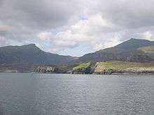
Nature reserve
.jpg)
Loch Druidibeg in the north of the island is a national nature reserve owned and managed by Scottish Natural Heritage. The reserve covers 1,677 hectares of machair, bog, freshwater lochs, estuary, heather moorland and hill.[29] Over 200 species of flowering plants have been recorded on the reserve, some of which are nationally scarce. South Uist is considered the best place in the UK for the aquatic plant Slender Naiad (Najas flexilis)[30] which is a European Protected Species.
Nationally important populations of breeding waders are also present, including redshank, dunlin, lapwing and ringed plover. The reserve is also home to greylag geese on the loch and in summer corncrakes on the machair. Otters and hen harriers are also seen.
There has been considerable controversy over hedgehogs on South Uist. The animals are not native to the islands, having been introduced in the 1970s to reduce garden pests. It is claimed they pose a threat to the eggs of ground nesting wading birds on the island. In 2003 the Uist Wader Project - headed by Scottish Natural Heritage - began a cull of hedgehogs in the area. Following a campaign and concerns over animal welfare, this cull was called off in 2007, instead hedgehogs are being captured and translocated to mainland Scotland.[31][32] [33]
Archaeology
The SEARCH project (Sheffield Environmental and Archaeological Research Campaign in the Hebrides) on South Uist has been developing a long-term perspective on changes in settlement and house form from the Bronze Age to the 19th century. Organisation within Iron Age roundhouses appears to have been very different from 19th century blackhouses in which the dwelling was shared with stock.[34]
The archaeological site of Cladh Hallan on South Uist is the only site in Great Britain where prehistoric mummies have been found.[35]
Notable residents
- Flora MacDonald (1722–1790), born at Milton. Known for her help of Bonnie Prince Charlie.
- Angus McPhee (1916–1997) born at Iochdar. Outsider artist.
- Danny Alexander (1972-) the Liberal Democrat Member of Parliament lived at West Geirnish on South Uist for three years as a child.[36]
- Mairi MacInnes (Scottish Gaelic Singer). Born in North Boisdale, One of the youngest Mod Gold Medalists - Isle of Skye 1982. Opened South Uist Causeway in the same year.
See also
- Bun Sruth, a loch in the southeast
- Easaval, a hill in the south
- Iochdar, a hamlet on the west coast
- Ushenish, a headland on the east coast
- Scottish island names
Footnotes
- 1 2 Gammeltoft, Peder "Scandinavian Naming-Systems in the Hebrides—A Way of Understanding how the Scandinavians were in Contact with Gaels and Picts?" in Ballin Smith et al (2007) p. 487
- 1 2 Area and population ranks: there are c. 300 islands over 20 ha in extent and 93 permanently inhabited islands were listed in the 2011 census.
- 1 2 National Records of Scotland (15 August 2013) (pdf) Statistical Bulletin: 2011 Census: First Results on Population and Household Estimates for Scotland - Release 1C (Part Two). "Appendix 2: Population and households on Scotland’s inhabited islands". Retrieved 17 August 2013.
- 1 2 Haswell-Smith, Hamish (2004). The Scottish Islands. Edinburgh: Canongate. ISBN 978-1-84195-454-7.
- ↑ The Chronicles of Mann. Manx Society. Vol XXII, Retrieved 4 July 2007.
- ↑ Germanic Lexicon Project Retrieved 4 July 2007.
- ↑ Ordnance Survey. Get-a-map (Map). 1:25,000. Leisure. Ordinance Survey. Retrieved 21 August 2013.
- ↑ General Register Office for Scotland (28 November 2003) Scotland's Census 2001 – Occasional Paper No 10: Statistics for Inhabited Islands. Retrieved 26 February 2012.
- ↑ Census 2011 stats BBC News. Retrieved 20 April 20-14.
- ↑ "Geology of Britain viewer". Maps.bgs.ac.uk. Retrieved 2011-07-13.
- ↑ "Assynt Stratigraphy". Es.ucl.ac.uk. Archived from the original on 2011-07-16. Retrieved 2011-07-13.
- ↑ "National Scenic Areas". SNH. Retrieved 30 Mar 2011.
- ↑ Mac an Tàilleir (2003) p. 116
- ↑ Innes, Bill (2006). Old South Uist. Catrine, Ayrshire: Stenlake Publishing. p. 3,4. ISBN 9781840333817.
- ↑ Innes, Bill (2006). Old South Uist. pp. 3, 4.
- ↑ South Uist:Archaeology and History of a Hebridean Island. Pearson, Shaples, Symonds. 2004. ISBN 978-0-7524-2905-2
- ↑ Owen, David (28 June 2009). "The missing links". The Observer. Archived from the original on 28 February 2014. Retrieved 28 February 2014.
- ↑ cybergolf.com re Askernish course. Retrieved 16 June 2007.
- ↑ "Crofters deny Old Tom claim". BBC News. 15 June 2007. Retrieved 2007-06-18.
- ↑ Forgan, Duncan (28 July 2007). "Island pins hopes on past links". Edinburgh: The Scotsman.
- ↑ Storas Uibhist press release
- ↑ David Owen (April 20, 2009). "The Ghost Course". New Yorker.
- ↑ "Land buyout reality for islanders". BBC News. 30 November 2006. Retrieved 4 January 2010.
- ↑ Stòras Uibhist
- ↑ Islanders pay £4.5m to be rid of feudal lairds The Independent newspaper. (1 December 2006) Retrieved 29 July 2007.
- ↑ The quiet revolution. (19 January 2007) Broadford. West Highland Free Press.
- ↑ QinetiQ: Hebrides Operations
- ↑ Ross, John (31 July 2009). "In 1930, the last islanders left. Now St Kilda Day celebrates their legacy". Edinburgh: The Scotsman. Retrieved 2009-08-10.
- ↑ SNH Loch Druidibeg Retrieved 29 July 2007.
- ↑ JNCC Slender Naiad report Retrieved 29 July 2007.
- ↑ Epping Forest Hedgehog Rescue Archived August 27, 2006, at the Wayback Machine. Retrieved 1 January 2007.
- ↑ Ross, John (21 February 2007). "Hedgehogs saved from the syringe as controversial Uist cull called off". Edinburgh: The Scotsman. Retrieved 2009-08-10.
- ↑ Paul Kelbie (2007-02-20). "Campaign wins reprieve for Uist hedgehogs". The Independent.
- ↑ Smith, H., Marshall, P. and Parker Pearson, M. 2001. Reconstructing house activity areas pp 249-270. In Albarella, U (ed) Environmental Archaeology: Meaning and Purpose. Kluwer Academic Publishers.
- ↑ BBC - History - The Mummies of Cladh Hallan
- ↑ "Alexander hears jobs and cuts fears". (27 Aug 2010) Aberdeen. Press and Journal.
References
- Ballin Smith, Beverley; Taylor, Simon; and Williams, Gareth (2007) West over Sea: Studies in Scandinavian Sea-Borne Expansion and Settlement Before 1300. Leiden. Brill. ISBN 97890-04-15893-1
- Mac an Tàilleir, Iain (2003) Ainmean-àite/Placenames. (pdf) Pàrlamaid na h-Alba. Retrieved 26 August 2012.
External links
![]() Media related to South Uist at Wikimedia Commons
Media related to South Uist at Wikimedia Commons
 South Uist travel guide from Wikivoyage
- The Island Where God Speaks Gaelic Raidió Teilifís Éireann documentary from 1971
- Archaeological Aerial Photographs
- Accommodation, Travel Advice, Members area, Hebrides forum and Photo gallery
- Accommodation, Events and Property in South Uist, North, Benbecula, Lewis and Harris
- Iochdar.co.uk, a website about outdoor recreation in South Uist
- StorasUibhist.com, the official website of the community-owned South Uist Estate
- Flags of the world - Hebrides
- An Gàrradh Mòr, Historic walled garden at Cille Bhrìghde
- The world in a spin: representing the Neolithic landscapes of South Uist in Internet Archaeology
- Rocket launches at South Uist
- Corporal missile inaccuracy revealed, The Guardian Sept 6 2003
- Askernish Golf Club
- Google Maps:Rocket launch site
- Am Paipear Community Newspaper
- Local Free Community Newspaper
 Chisholm, Hugh, ed. (1911). "Uist, North and South". Encyclopædia Britannica (11th ed.). Cambridge University Press.
Inhabited islands of the Hebrides | ||
|---|---|---|
| Inner Hebrides | 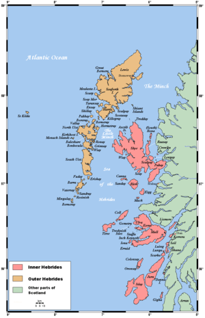 | |
| Outer Hebrides | ||
|  | ||||||||||||||||||||||||||||
|
| |||||||||||||||||||||||||||||
| |||||||||||||||||||||||||||||
| |||||||||||||||||||||||||||||
| |||||||||||||||||||||||||||||
| |||||||||||||||||||||||||||||
| |||||||||||||||||||||||||||||
| |||||||||||||||||||||||||||||
Coordinates: 57°16′N 7°19′W / 57.267°N 7.317°W