Pabbay, Harris
For other places with the same name, see Pabbay (disambiguation).
| Gaelic name | Pabaigh |
|---|---|
| Pronunciation | [ˈpʰapaj] |
| Norse name | Papey |
| Meaning of name | Island of the papar |
| Location | |
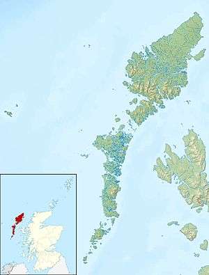 Pabbay Pabbay shown within the Outer Hebrides | |
| OS grid reference | NF888876 |
| Physical geography | |
| Island group | Uists and Barra |
| Area | 820 ha (3.2 sq mi) |
| Area rank | 60 [1] |
| Highest elevation | Beinn a' Chàrnain 196 m (643 ft) |
| Administration | |
| Sovereign state | United Kingdom |
| Country | Scotland |
| Council area | Na h-Eileanan Siar |
| Demographics | |
| Population | 0[2] |
| References | [3][4] |
Pabbay (Scottish Gaelic: Pabaigh) is an uninhabited island in the Outer Hebrides of Scotland which lies in the Sound of Harris between Harris and North Uist. The name comes from Papey, which is Norse for "Island of the papar (Culdee)"
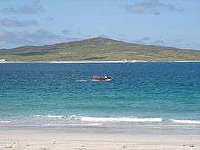
The island was once very fertile, supporting a three-figure population and exporting corn, barley and illicit whisky. Most of the stewards of St. Kilda were Pabbay men. The island was cleared for sheep in 1846.
Footnotes
- ↑ Area and population ranks: there are c. 300 islands over 20 ha in extent and 93 permanently inhabited islands were listed in the 2011 census.
- ↑ National Records of Scotland (15 August 2013) (pdf) Statistical Bulletin: 2011 Census: First Results on Population and Household Estimates for Scotland - Release 1C (Part Two). "Appendix 2: Population and households on Scotland’s inhabited islands". Retrieved 17 August 2013.
- ↑ Haswell-Smith, Hamish (2004). The Scottish Islands. Edinburgh: Canongate. ISBN 978-1-84195-454-7.
- ↑ Ordnance Survey. Get-a-map (Map). 1:25,000. Leisure. Ordinance Survey. Retrieved 21 August 2013.
Coordinates: 57°46′14″N 7°14′3″W / 57.77056°N 7.23417°W
| Inhabited islands | ||
|---|---|---|
| Other islands | ||
| Settlements |
| |
| Districts | ||
| Geographical features | ||
| Historical sites | ||
|  | ||||||||||||||||||||||||||||
|
| |||||||||||||||||||||||||||||
| |||||||||||||||||||||||||||||
| |||||||||||||||||||||||||||||
| |||||||||||||||||||||||||||||
| |||||||||||||||||||||||||||||
| |||||||||||||||||||||||||||||
| |||||||||||||||||||||||||||||
This article is issued from Wikipedia - version of the 8/14/2015. The text is available under the Creative Commons Attribution/Share Alike but additional terms may apply for the media files.