Saughall Massie
| Saughall Massie | |
| — Hamlet — | |
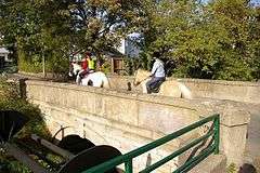 The Grade II listed Saughall Massie Bridge over Arrowe Brook, built in 1829 by Sir Thomas Brassey |
|
 Saughall Massie |
|
| Population | 1,260 (2001 Census)[1] |
|---|---|
| OS grid reference | SJ247882 |
| – London | 181 mi (291 km)[2] SE |
| Metropolitan borough | Wirral |
| Metropolitan county | Merseyside |
| Region | North West |
| Country | England |
| Sovereign state | United Kingdom |
| Post town | WIRRAL |
| Postcode district | CH49 |
| Dialling code | 0151 |
| ISO 3166 code | GB-WRL |
| Police | Merseyside |
| Fire | Merseyside |
| Ambulance | North West |
| EU Parliament | North West England |
| UK Parliament | Wallasey |
|
|
Coordinates: 53°23′09″N 3°08′00″W / 53.3859°N 3.1333°W
- This article is about the hamlet of Saughall Massie. See also Saughall for the village and civil parish in Cheshire West and Chester unitary authority.
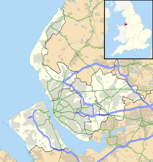
Saughall Massie (local /ˈsɒɡɔːlˈmæsi/) is a large hamlet on the Wirral Peninsula, Merseyside, England. It is bordered by Greasby, Meols, Moreton and Upton. The village is part of the Moreton West & Saughall Massie Ward of the Metropolitan Borough of Wirral and the parliamentary constituency of Wallasey. A small village primarily made up of large fields owned by local farmers, Saughall Massie had a population of 1,260 at the time of the 2001 Census.[1]
History
The Saughall part of the name has been recorded as deriving from salh and halh, meaning "Hall where sallows or willow shrubs grew" or "Willow nook".[3] The name de Massie, de Massey or de Mascy has been connected to the Wirral since the time of the Norman Conquest. Baron Hamon de Mascey, whose family came from the settlement of Mascey near Avranches, Normandy, established Birkenhead Priory in 1150. His relations, the Masseys of Sale, settled on the Wirral during the reign of King John were supposed to have given their name to the village.[4][5] Over the years the name has been spelt as: Saligh (1249); Salghale (1309); Salgham (1385); Saughoughe (1546).[3]
Formerly a township in the Bidston Parish of the Wirral Hundred, the population of Saughall Massie and the nearby hamlet of Carr Houses was 98 in 1801, 176 in 1851 and 186 in 1901.[6] On 1 April 1974, local government reorganisation in England and Wales resulted in most of Wirral, including Saughall Massie, transfer from the county of Cheshire to Merseyside.
The village consists of a number of historic buildings dating from the seventeenth century. In order to help preserve its historic and agricultural characteristics, Saughall Massie was designated a conservation area in January 1974.[7] Saughall Massie Bridge, the first bridge constructed by notable Victorian civil engineer Sir Thomas Brassey in 1829,[8] was awarded Grade II listed status by English Heritage in 2007.[9]
USAAF plane crash
On January 9th 1944 Lieutenant Jay Frederick Simpson, an American pilot from Gillett, Wisconsin was killed whilst test flying a Republic P-47 Thunderbolt (serial no. 42-75584) over Moreton. The plane had taken off from the US Burtonwood Airbase in Lancashire earlier. It flew out to sea and on its return over Hoylake he reported that the plane was on fire. It circled over the RAF West Kirby and was seen to lose height and flip over, and crash in a field near the Arrowe Brook south of the village. Pieces were dug up in 1974 and now reside in the museum of the War Plane Wreck Investigation Group at Fort Perch Rock, New Brighton. A small memorial plaque was unveiled on 21st March 2005 on the bridge across the Arrowe Brook on Saughall Massie Road overlooking the crash site.
Geography
Saughall Massie is in the northern part of the Wirral Peninsula, approximately 2.5 km (1.6 mi) south-east of the Irish Sea at Meols, about 4.5 km (2.8 mi) east of the Dee Estuary at West Kirby and about 7 km (4.3 mi) west of the River Mersey at Seacombe. The hamlet is situated at an elevation of around 15 m (49 ft) above sea level.[10]
Greasby Brook converges with Arrowe Brook to the south-west of Saughall Massie.
 |
Meols | Moreton | Moreton | |
| Hoylake | |
Upton | ||
| ||||
| | ||||
| Larton | Greasby | Greasby |
Government
Saughall Massie is part of the Metropolitan Borough of Wirral, in the metropolitan county of Merseyside. The settlement is part of the parliamentary constituency of Wallasey. The current Member of Parliament is Angela Eagle, a Labour representative, who has been the MP since 1992.
The area is also part of a local government ward of the Metropolitan Borough of Wirral, this being Moreton West and Saughall Massie Ward. Saughall Massie is represented on Wirral Metropolitan Borough Council by three councillors. These are Bruce Berry, Chris Blakeley and Steve Williams, who are all Conservative councillors.[11] The most recent local elections took place on 22 May 2014.
| Party | Candidate | Votes | % | ± | |
|---|---|---|---|---|---|
| Conservative | Bruce BERRY | 1817 | 43.9 | ||
| Labour | Karl Gerard GREANEY | 1484 | 35.85 | ||
| Green | Perle Winifred SHELDRICKS | 160 | 3.87 | ||
| UKIP | Susan Jane WHITHAM | 678 | 16.38 | ||
The electorate numbered 10,885, there was a turnout of 38.1% and the majority is 333. The result was declared at 11:38.[13]
Transport
Road
The B5192 Saughall Massie Road, which heads west to Grange, is the main thoroughfare through Saughall Massie. The B5192 also connects to the A5027 Upton Bypass bordering to the east, the latter joining Junction 2 of the M53 motorway just to the north-east of Saughall Massie.
Bus
Services operating along Saughall Road, as of 2012:
| Number | Route | Operator | Days of Operation |
|---|---|---|---|
| 17/17A | Moreton-Clatterbridge Hospital | Avon Buses | Monday-Friday daytime |
| 17/17A | Moreton-Clatterbridge Hospital | Arriva North West | Saturday daytime |
| 38A | Heswall or West Kirby-Bromborough | Stagecoach | Monday-Saturday evenings and Sunday |
| 901 | Leasowe Railway Station-Moreton | Cumfybus | Monday-Sunday |
Rail
Saughall Massie is equidistant to both Moreton and Meols railway stations on the Wirral Line of the Merseyrail network. Saughall Massie is also a similar distance from Upton railway station on the Borderlands Line, operated by Arriva Trains Wales.
See also
- Saughall, a village in the Cheshire West and Chester area of Cheshire.
- Listed buildings in Saughall Massie
References
- 1 2 Wirral 2001 Census: Saughall Massie, Metropolitan Borough of Wirral, archived from the original on 29 September 2007, retrieved 9 July 2010
- ↑ "Coordinate Distance Calculator". boulter.com. Retrieved 6 March 2016.
- 1 2 Saughall Massie, National Museums Liverpool, retrieved 9 July 2010
- ↑ Armitstead, Kenrick, The Massie Family: Early History, retrieved 17 May 2007
- ↑ The Diocese of Chester: Birkenhead Deanery, chester.anglican.org, retrieved 9 July 2010
- ↑ Cheshire Towns & Parishes: Saughall Massie, GENUKI UK & Ireland Genealogy, retrieved 17 May 2007
- ↑ Conservation Areas, Metropolitan Borough of Wirral, retrieved 9 July 2010
- ↑ Murphy, Liam (21 November 2005), Village bridge the first by engineering giant, Trinity Mirror North West & North Wales Limited: Daily Post, retrieved 30 January 2009
- ↑ Plaque unveiled at bridge, Wirral Globe, 4 May 2007, retrieved 17 May 2007
- ↑ "SRTM & Ordnance Survey Elevation Data in PHP". Retrieved 1 November 2016.
- ↑ Wirral Borough Council, Your Councillors by Ward Accessed 2014-05-22
- ↑ Election Result for 22 May 2014, Metropolitan Borough of Wirral, retrieved 29 May 2014
- ↑ Wirral Borough Council, Election Result for Moreton West and Saughall Massie ward on 22 May 2014 Accessed 2014-05-29
Bibliography
- Mortimer, William Williams (1847). The History of the Hundred of Wirral. London: Whittaker & Co. p.206.
External links
| Wikimedia Commons has media related to Saughall Massie. |