Oxton, Merseyside
| Oxton | |
| — Village — | |
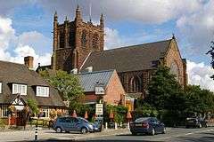 St. Saviour's Church with the Caernarvon Castle public house to the left |
|
 Oxton |
|
| Population | 14,232 (2011 Census.Ward)[1] |
|---|---|
| OS grid reference | SJ303876 |
| – London | 178 mi (286 km)[2] SE |
| Metropolitan borough | Wirral |
| Metropolitan county | Merseyside |
| Region | North West |
| Country | England |
| Sovereign state | United Kingdom |
| Post town | BIRKENHEAD |
| Postcode district | CH42 |
| Post town | PRENTON |
| Postcode district | CH43 |
| Dialling code | 0151 |
| ISO 3166 code | GB-WRL |
| Police | Merseyside |
| Fire | Merseyside |
| Ambulance | North West |
| EU Parliament | North West England |
| UK Parliament | Birkenhead |
|
|
Coordinates: 53°22′51″N 3°02′54″W / 53.3807°N 3.0483°W
Oxton is a suburb of Birkenhead, Merseyside, England. Administratively it is a ward of the Metropolitan Borough of Wirral. Originally a village in its own right, became part of the Municipal Borough of Birkenhead upon its creation in 1877. Before local government reorganisation on 1 April 1974, it was part of the County Borough of Birkenhead, within the county of Cheshire.
History
The name Oxa-tún derives from Old Norse, meaning "a farm or enclosure where oxen are kept". By 1278, the name had been adapted into Old English as Oxeton and was recorded as Oxon in 1549.[3]
Oxton was once one of the most affluent areas in England mainly due to its proximity to Liverpool and the fact that along with various other Merseyside locations, it was a favourite residential area for wealthy Liverpool merchants and tradesmen of the time. Oxton Village is a mainly early Victorian era settlement with fine sandstone and brick built houses, many of which now form part of a conservation area designated in April 1979 and administered by the Metropolitan Borough of Wirral.[4] Some of these buildings have been designated by English Heritage as Grade II listed.
A significant part of the land on which Oxton is situated was part of the Estate of the Earl of Shrewsbury - this has been commemorated over the years in many of the road names, which bear the family names and titles of the various Earls; Alton Road, Beresford Road, Chetwynd Road, Ingestre Road, Shrewsbury Road, Talbot Road, Waterford Road and Wexford Road. The oldest pub in Oxton Village is called the 'Shrewsbury Arms' (presumably for the same reason) and the bar which is now known as the 'Oxton Bar and Kitchen' was formerly the 'Talbot Hotel'.
Christ Church opened in 1849[5] and has a Father Willis organ,[6] installed in 1888.
Geography
Location
The Wirral peninsula is formed of Triassic Keuper and Bunter sandstones covered by glacially deposited boulder clay. The historic settlement of Oxon-hill laid to the north-eastern side of the peninsula on the sandstone ridge near to current location of St Saviours Church and the Caernarfon Castle public house[7]
Oxton Village pre-dates the conurbation that developed around Birkenhead, of which it now forms part. It is bordered to the north by Claughton and to the south by Prenton. Birkenhead town centre lies to the east.[8]
Originally an agricultural community, Oxton became a desirable residential location for the middle classes and bourgeoisie[9] as the economy of 19th century Birkenhead and Liverpool grew.[8] The north east of the conservation area, at the junction of Victoria Mount, Rose Mount, Village Road and Claughton Firs developed as a commercial centre with restaurants, pubs, cafes and shops.[10][11]
 |
Bidston Hill | Claughton | Birkenhead | |
| Noctorum | |
Tranmere | ||
| ||||
| | ||||
| Prenton | Prenton | Prenton |
Conservation Area and Oxton Village
Oxton Village Conservation Area was established in 1979 by Wirral Borough Council in order to "preserve and enhance the village’s distinctive character".[12] Soon afterwards, a registered charity was founded to promote the Conservation Area; this was named The Oxton Society.[13] This objective of this charity is to work in partnership with the Council, local businesses and the community to pursue this objective.
The approximate boundary is bounded by Shrewsbury Road to the north, Fairview Road to the east, Arno Road to the south and Talbot Road to the west. Irregular in places, the boundary has a number of ‘pockets’ encompassing small groups of properties or parts of streets. In 2010 Wirral Council commissioned an appraisal for Oxton Village Conservation Areas that evaluated and analysed various features which gives the conservation area its special architectural and historic interest.[7] The appraisal made recommendations to extend the Conservation Area boundaries of Normanston Road & Derwent Road, Birch Road, Village Road & Wellington Road and Talbot Road, Mill Hill and Ingestre Road. The consultation period for the boundary extensions has now closed and the extensions are in the process of being adopted.[12]
Post Town Controversy
Due to a redefining of post towns by the Royal Mail in 2003, Oxton is partially identified as being within Prenton, which is a geographically separate suburb of Birkenhead. However, whilst this was only a postal change and Oxton itself still remains a part of Birkenhead, no reference is made to Oxton within the address. In its May 22, 2003 edition, the Liverpool Echo[14] reported that "Jeremy Watson,of the Oxton Society, has called on the Royal Mail to have a ballot", however, the code at that time did not allow a request to ballot. A similar complaint was made by on behalf of Prenton residents when Royal Mail defined part of Prenton to be within Oxton.[15]
Education
Independent and selective Birkenhead School was exclusively a boys' school from its founding in 1860 until 2000, when its Sixth Form became co-educational. It became fully co-educational in 2008. Birkenhead High School was formally an independent selective school for girls but became a state-funded all-ability Academy school in 2009.[16] Both changes are driven by falling numbers of pupils in the schools as a result of the abolition of the Assisted Places Scheme. Despite this both schools maintain their place around the top of the Wirral A Level results.
In addition Prenton Preparatory School lies in the heart of the Conservation Area and Oxton St Saviour's is the local primary school. A number of other schools lie just outside the boundary of Oxton, including St. Anselm's College (boys, RC), Redcourt St Anselm's (co-ed, prep) and Townfield Primary School.
Sport
Oxton Cricket & Sports Club is also located here. Founded in 1875 as Oxton Cricket Club,[17] other sports played at the club include tennis, lacrosse, squash and bowls.
Demographics
At the 2001 Census, the population of Oxton was 14,066, consisting of 6,680 males and 7,386 females.[18]
Some 2005 demographic statistics of area CH43, which encompasses the geographical area of Oxton, Claughton and parts of Bidston and Noctorum, (total CH43 population (2005): 36,443) are:
| Median Age | 39 |
| % Retirees | 21.9% |
| % Unemployed | 4.4% |
| Total Migrants | 3,497 |
| % Total Migrants | 9.6% |
| Average distance travelled to fixed place of work | 12 km |
Governance
Oxton is part of the Birkenhead parliamentary constituency. Frank Field MP (Labour) is therefore Oxton's parliamentary representative.
Local Councillors
After reorganisation in 2004, Oxton forms an electoral ward of the Metropolitan Borough of Wirral, with an electorate of 11,237 (as of 6 May 2010).[19]
| Metropolitan Borough of Wirral: Oxton Ward | ||||
|---|---|---|---|---|
| Councillor | Party | |||
| P. Doughty | Labour Party (UK) | |||
| A. Brighouse | Liberal Democrat | |||
| Mrs Patricia Williams | Liberal Democrat | |||
2015 local elections
The results of the Local Election Result for Oxton ward on 7 May 2015 were: .[20]
| Party | Candidate | Votes | % | ± | |
|---|---|---|---|---|---|
| Labour | Paul Andrew DOUGHTY | 3,085 | 39.72 | ||
| Green | Liz HEYDON | 424 | 5.46 | ||
| Liberal Democrat | Stuart KELLY | 2,788 | 35.90 | ||
| Conservative | Hilary Margaret JONES | 845 | 11.00 | ||
| UKIP | David Charles MARTIN | 615 | 7.92 | ||
Electorate: 11,236; Turnout: 69.4%; Majority: 297
Notable connections
- Sir Leslie Patrick Abercrombie - town planner
- Michael Chan - Baron Chan of Oxton in the County of Merseyside
- Colonel Philip Toosey - military officer
- Cyril Scott - British composer (1879-1970)
See also
References
- ↑ "Ward population 2011". Retrieved 1 June 2015.
- ↑ "Coordinate Distance Calculator". boulter.com. Retrieved 6 March 2016.
- ↑ Oxton, National Museums Liverpool, retrieved 11 July 2010
- ↑ Conservation Areas, Metropolitan Borough of Wirral, retrieved 11 July 2010
- ↑ Christ Church, Oxton, Birkenhead, Church of England, retrieved 11 September 2009
- ↑ 'Father Willis' organ, Christ Church, retrieved 11 September 2009
- 1 2 https://www.wirral.gov.uk/downloads/3796
- 1 2 https://www.wirral.gov.uk/downloads/2315
- ↑ "History". Williamson Art Gallery & Museum. Retrieved 28 October 2015.
- ↑ "Oxton Village 'A Voyage of Discovery'". The Birkenhead History Society. Retrieved 28 October 2015.
- ↑ "Oxton Village Wirral Merseyside Drive". Youtube. Retrieved 28 October 2015.
- 1 2 https://www.wirral.gov.uk/my-services/environment-and-planning/built-conservation/conservation-areas/oxton-village
- ↑ "About the Oxton Society". The Oxton Society. Retrieved 28 October 2015.
- ↑ "Residents in address battle.(News)". Liverpool Echo. 22 May 2003. Retrieved 28 October 2015.
- ↑ "Responses to Postcomm's Review of Royal Mail's Licence – Condition 20 Postcode Address File Code of Practice" (PDF). Ofcom. Retrieved 28 October 2015.
- ↑ School prepares to make historic move, Wirral Globe, 8 November 2007, retrieved 14 January 2008
- ↑ Club History, Oxton Cricket & Sports Club, retrieved 11 July 2010
- ↑ 2001 Census: Oxton, Office for National Statistics, retrieved 2 July 2007
- ↑ Election Result for Oxton Ward, Metropolitan Borough of Wirral, 6 May 2010, retrieved 11 July 2010
- ↑ Election Result for Oxton ward on 7 May 2015, retrieved 6 August 2015
Further reading
- Beazley, F.C. (1930). The Parish Church of S. Saviour, Oxton. Willmer Bros. OCLC 12829561.
- Boumphrey, Ian (2007). Yesterday's Birkenhead: A Pictorial History 1860 to 1960 including Prenton, Oxton, Bidston, Upton, Woodchurch, Tranmere, Bebington, New Ferry and Rock Ferry. The Author. ISBN 9781899241262.
- Boumphrey, Ian; Boumphrey, Marilyn (1981). Yesterday's Wirral: Birkenhead, Prenton and Oxton. Ian & Marilyn Boumphrey. ISBN 9780950725512. OCLC 16599808.
- Boumphrey, Ian; Boumphrey, Marilyn (1992). Yesterday's Wirral No. 7: More of Birkenhead, Oxton and Prenton Including Bidston and Upton. Ian & Marilyn Boumphrey. ISBN 9780950725574. OCLC 315929082.
- Mortimer, William Williams (1847). The History of the Hundred of Wirral. London: Whittaker & Co. pp287-288.
External links
| Wikimedia Commons has media related to Oxton, Birkenhead. |
- Oxton Village Online
- The Oxton Society
- The Oxton Artists
- The Oxton Society: Oxton In History, by John Green (2006) Word document Acrobat pdf file