Saint-Préjet-d'Allier
| Saint Préjet d'Allier | ||
|---|---|---|
|
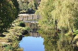
The Ance du Sud, in Saint-Préjet-d'Allier | ||
| ||
 Saint Préjet d'Allier | ||
|
Location within Auvergne-Rhône-Alpes region  Saint Préjet d'Allier | ||
| Coordinates: 44°54′58″N 3°37′23″E / 44.9161°N 3.6231°ECoordinates: 44°54′58″N 3°37′23″E / 44.9161°N 3.6231°E | ||
| Country | France | |
| Region | Auvergne-Rhône-Alpes | |
| Department | Haute-Loire | |
| Arrondissement | Brioude | |
| Canton | Gorges de l'Allier-Gévaudan | |
| Intercommunality | Pays de Saugues | |
| Government | ||
| • Mayor (2008–2014) | Jean-Claude Morel | |
| Area1 | 24.46 km2 (9.44 sq mi) | |
| Population (1999)2 | 199 | |
| • Density | 8.1/km2 (21/sq mi) | |
| Time zone | CET (UTC+1) | |
| • Summer (DST) | CEST (UTC+2) | |
| INSEE/Postal code | 43220 / 43580 | |
| Elevation |
711–1,135 m (2,333–3,724 ft) (avg. 850 m or 2,790 ft) | |
|
1 French Land Register data, which excludes lakes, ponds, glaciers > 1 km² (0.386 sq mi or 247 acres) and river estuaries. 2 Population without double counting: residents of multiple communes (e.g., students and military personnel) only counted once. | ||

Saint Préjet d'Allier is a commune in the Haute-Loire department in south-central France.
Geography
The town is 35 km (22 mi) west of Le Puy-en-Velay.
See also
References
External links
| Wikimedia Commons has media related to Saint-Préjet-d'Allier. |
- (English) Official Web site
This article is issued from Wikipedia - version of the 2/8/2016. The text is available under the Creative Commons Attribution/Share Alike but additional terms may apply for the media files.