Lavaudieu
| Lavaudieu | ||
|---|---|---|
|
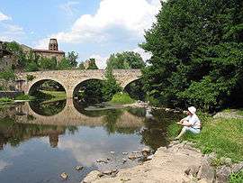
The medieval village, the old bridge on the Senouire River and the St. André abbey. | ||
| ||
 Lavaudieu | ||
|
Location within Auvergne-Rhône-Alpes region  Lavaudieu | ||
| Coordinates: 45°15′49″N 3°27′17″E / 45.2636°N 3.4547°ECoordinates: 45°15′49″N 3°27′17″E / 45.2636°N 3.4547°E | ||
| Country | France | |
| Region | Auvergne-Rhône-Alpes | |
| Department | Haute-Loire | |
| Arrondissement | Brioude | |
| Canton | Brioude-Sud | |
| Government | ||
| • Mayor (2001–2008) | Marie-Andrée Perrey | |
| Area1 | 17.54 km2 (6.77 sq mi) | |
| Population (1999)2 | 225 | |
| • Density | 13/km2 (33/sq mi) | |
| Time zone | CET (UTC+1) | |
| • Summer (DST) | CEST (UTC+2) | |
| INSEE/Postal code | 43117 / 43100 | |
| Elevation |
438–727 m (1,437–2,385 ft) (avg. 550 m or 1,800 ft) | |
|
1 French Land Register data, which excludes lakes, ponds, glaciers > 1 km² (0.386 sq mi or 247 acres) and river estuaries. 2 Population without double counting: residents of multiple communes (e.g., students and military personnel) only counted once. | ||

Lavaudieu is a commune in the Haute-Loire department in south-central France. Buildings include the Romanesque Lavaudieu Abbey, otherwise Lavaudieu Priory (Abbaye Saint-André de Lavaudieu), built by St Robert, the first abbot of La Chaise-Dieu, in the 11th century,[1] which was at first a Benedictine priory, and later a house of secular canonesses from the Auvergnat nobility. It was raised to the status of abbey in 1719.
Geography
The village lies on the right bank of the Senouire, which flows westward through the commune.
References
See also
| Wikimedia Commons has media related to Lavaudieu. |
This article is issued from Wikipedia - version of the 6/21/2015. The text is available under the Creative Commons Attribution/Share Alike but additional terms may apply for the media files.