Sainte-Florine
| Sainte-Florine | |
|---|---|
|
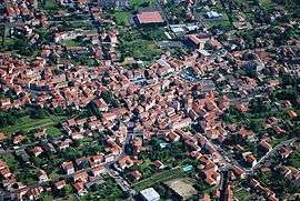
An aerial view of Sainte-Florine | |
 Sainte-Florine | |
|
Location within Auvergne-Rhône-Alpes region  Sainte-Florine | |
| Coordinates: 45°24′21″N 3°19′05″E / 45.4058°N 3.3181°ECoordinates: 45°24′21″N 3°19′05″E / 45.4058°N 3.3181°E | |
| Country | France |
| Region | Auvergne-Rhône-Alpes |
| Department | Haute-Loire |
| Arrondissement | Brioude |
| Canton | Auzon |
| Government | |
| • Mayor (2001–2008) | Nicole Chassin |
| Area1 | 7.67 km2 (2.96 sq mi) |
| Population (1999)2 | 3,002 |
| • Density | 390/km2 (1,000/sq mi) |
| Time zone | CET (UTC+1) |
| • Summer (DST) | CEST (UTC+2) |
| INSEE/Postal code | 43185 / 43250 |
| Elevation |
400–511 m (1,312–1,677 ft) (avg. 430 m or 1,410 ft) |
|
1 French Land Register data, which excludes lakes, ponds, glaciers > 1 km² (0.386 sq mi or 247 acres) and river estuaries. 2 Population without double counting: residents of multiple communes (e.g., students and military personnel) only counted once. | |
Sainte-Florine is a commune in the Haute-Loire department in south-central France.
See also
References
| Wikimedia Commons has media related to Sainte-Florine. |
This article is issued from Wikipedia - version of the 3/15/2016. The text is available under the Creative Commons Attribution/Share Alike but additional terms may apply for the media files.