Rosedale, Oklahoma
| Rosedale, Oklahoma | |
|---|---|
| Town | |
 Location of Rosedale, Oklahoma | |
| Coordinates: 34°55′8″N 97°11′6″W / 34.91889°N 97.18500°WCoordinates: 34°55′8″N 97°11′6″W / 34.91889°N 97.18500°W | |
| Country | United States |
| State | Oklahoma |
| County | McClain |
| Area | |
| • Total | 0.1 sq mi (0.2 km2) |
| • Land | 0.1 sq mi (0.2 km2) |
| • Water | 0.0 sq mi (0.0 km2) |
| Elevation | 1,050 ft (320 m) |
| Population (2000) | |
| • Total | 66 |
| • Density | 855.3/sq mi (330.2/km2) |
| Time zone | Central (CST) (UTC-6) |
| • Summer (DST) | CDT (UTC-5) |
| FIPS code | 40-64000[1] |
| GNIS feature ID | 1097443[2] |
Rosedale is a town in McClain County, Oklahoma, United States. The population was 66 at the 2000 census.
Geography
Rosedale is located at 34°55′08″N 97°11′06″W / 34.918793°N 97.184869°W.[3] According to the United States Census Bureau, the town has a total area of 0.1 square miles (0.26 km2), all of it land.
Rosedale is located along State Highway 59.[4]
Demographics
| Historical population | |||
|---|---|---|---|
| Census | Pop. | %± | |
| 1940 | 112 | — | |
| 1950 | 136 | 21.4% | |
| 1960 | 88 | −35.3% | |
| 1970 | 98 | 11.4% | |
| 1980 | 97 | −1.0% | |
| 1990 | 48 | −50.5% | |
| 2000 | 66 | 37.5% | |
| 2010 | 68 | 3.0% | |
| Est. 2015 | 70 | [5] | 2.9% |
As of the census[1] of 2000, there were 66 people, 26 households, and 19 families residing in the town. The population density was 855.3 people per square mile (318.5/km2). There were 31 housing units at an average density of 401.7 per square mile (149.6/km2). The racial makeup of the town was 86.36% White, 6.06% from other races, and 7.58% from two or more races. Hispanic or Latino of any race were 21.21% of the population.
There were 26 households out of which 38.5% had children under the age of 18 living with them, 61.5% were married couples living together, 11.5% had a female householder with no husband present, and 26.9% were non-families. 26.9% of all households were made up of individuals and 15.4% had someone living alone who was 65 years of age or older. The average household size was 2.54 and the average family size was 3.11.
In the town the population was spread out with 31.8% under the age of 18, 6.1% from 18 to 24, 30.3% from 25 to 44, 13.6% from 45 to 64, and 18.2% who were 65 years of age or older. The median age was 29 years. For every 100 females there were 106.3 males. For every 100 females age 18 and over, there were 114.3 males.
The median income for a household in the town was $11,875, and the median income for a family was $15,938. Males had a median income of $0 versus $16,750 for females. The per capita income for the town was $7,285. There were 53.3% of families and 53.3% of the population living below the poverty line, including 77.3% of under eighteens and none of those over 64.
Notable people
- Jimmy Wakely Country-Western singer and actor, and was raised in Rosedale.
- Willis Whitfield, physicist and inventor of the "Cleanroom" used in the manufacture of IC chips, and was born in Rosedale.[7][8]
References
- 1 2 "American FactFinder". United States Census Bureau. Retrieved 2008-01-31.
- ↑ "US Board on Geographic Names". United States Geological Survey. 2007-10-25. Retrieved 2008-01-31.
- ↑ "US Gazetteer files: 2010, 2000, and 1990". United States Census Bureau. 2011-02-12. Retrieved 2011-04-23.
- ↑ Official State Map (Map) (2008 ed.). Oklahoma Department of Transportation.
- ↑ "Annual Estimates of the Resident Population for Incorporated Places: April 1, 2010 to July 1, 2015". Retrieved July 2, 2016.
- ↑ "Census of Population and Housing". Census.gov. Retrieved June 4, 2015.
- ↑ http://obits.abqjournal.com/obits/show/230629
- ↑ http://www.networkworld.com/community/node/81860
Municipalities and communities of McClain County, Oklahoma, United States | ||
|---|---|---|
| Cities | 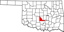 | |
| Towns | ||
| Unincorporated communities |
| |
| Footnotes | ‡This populated place also has portions in an adjacent county or counties | |