Rondonópolis
| Rondonópolis, Brazil | |||
|---|---|---|---|
| Municipality | |||
| The Municipality of Rondonópolis | |||
 | |||
| |||
| Nickname(s): Nation Capital of Agribusiness (Capital Nacional do Agronegocio in Portuguese) | |||
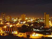
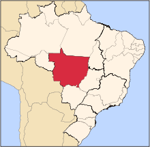
 Location of Rondonópolis | |||
 Rondonópolis, Brazil Location of Rondonópolis | |||
| Coordinates: 16°28′15″S 54°38′09″W / 16.47083°S 54.63583°W | |||
| Country |
| ||
| Region | Central-West | ||
| State |
| ||
| Founded | December 10, 1953 | ||
| Government | |||
| • Mayor | Percival Muniz (PPS) | ||
| Area | |||
| • Total | 10,787.90 km2 (4,165.232 sq mi) | ||
| Elevation | 227 m (745 ft) | ||
| Population (2012) | |||
| • Total | 202,309 | ||
| • Density | 47.764/km2 (123.71/sq mi) | ||
| Time zone | UTC-4 (UTC-4) | ||
| • Summer (DST) | UTC-3 (UTC-3) | ||


Rondonópolis (formerly known as Rio Vermelho (Red River)) is the third-largest municipality in Mato Grosso. It is located around 215 km (134 mi) from Cuiabá, the capital of the state.
Overview
According to the Brazilian census in 2012 the town had 202,309 inhabitants.
The city is growing quickly because many industries settled there and the soybean plantation is considered a "new gold rush" in the region, attracting emigrants from distant regions of Brazil. These people are from the South and Southeast regions who used to work with cattle ranching. The farming is extensive and very automated compared to other parts of Brasil. The farms are interesting as when the industry was labor-intensive the owners built small villages around the main house for the workers. These "villages" were self-contained and included schools and medical facilities. Rarely used now for their original purpose many still stand. They are seen as an island surrounded by trees in the middle of soy bean plants stretching to the horizon.
In August 2007 the Italian wind orchestra Orchestra Fiati Giovanile Italiana e Coro "I Music Piemonteis" conducted by Ugo Bairo, and his choir, conducted by Carmelo Luca Sambataro performed there. There he premiered his wind composition dedicated to the local government: The Mato Grosso March. The city is situated on the Cerrado, high tableland intersected by deep gorges containing butte and mesa formations.
The city is also the jumping off point for tourists and sportsmen visiting the Northern Pantanal. Rondonópolis has a small airport, Maestro Marinho Franco Municipal Airport with only one airline TRIP Linhas Aéreas, connecting the city with other cities in the Mato Grosso state such as Alta Floresta, Sinop and Cuiabá.
Distances from
- Cuiabá 215 km - (134 miles)
- Campo Grande 485 km - (301 miles)
- Brasília 922 km - (573 miles)
- São Paulo 1.493 km - (928 miles)
- Rio de Janeiro 1.806 km - (1,122 miles)
References
Coordinates: 16°28′S 54°38′W / 16.467°S 54.633°W
Capital: Cuiabá | |||||||||||||||||||||||||||||||
| Centro-Sul Mato-Grossense |
|  | |||||||||||||||||||||||||||||
| Nordeste Mato-Grossense |
| ||||||||||||||||||||||||||||||
| Norte Mato-Grossense |
| ||||||||||||||||||||||||||||||
| Sudeste Mato-Grossense |
| ||||||||||||||||||||||||||||||
| Sudoeste Mato-Grossense |
| ||||||||||||||||||||||||||||||