Peixoto de Azevedo
| Peixoto de Azevedo | |
|---|---|
| Municipality | |
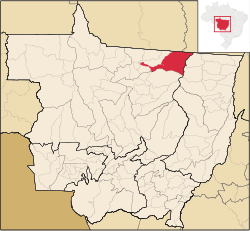 Location in Mato Grosso state | |
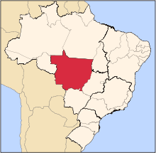
 Peixoto de Azevedo Location in Brazil | |
| Coordinates: 10°13′23″S 54°58′47″W / 10.22306°S 54.97972°WCoordinates: 10°13′23″S 54°58′47″W / 10.22306°S 54.97972°W | |
| Country |
|
| Region | Central-West Region |
| State | Mato Grosso |
| Time zone | BRT-1/BRST-1 (UTC-4/-3) |

Gold specimen from the Alta Floresta Gold Province, near Peixoto de Azevedo. 2.6 x 2.2 x 1.4 cm.
Peixoto de Azevedo is a municipality in the state of Mato Grosso, Brazil. On September 29, 2006, the Brazilian Gol Transportes Aéreos Flight 1907 crashed approximately 200 kilometers (120 mi) east of the city center. Peixoto de Azevedo was the ancient location of Panará's Indian tribes. They were expelled by the gold rush in the region. Now, the Panará's tribes are located in the Indigenous Area Kapoto-Jarinã, created by the Villa-Boas brothers.
The nearby Alta Floresta Gold Province comprises 38 gold mines. [1]
References
Capital: Cuiabá | |||||||||||||||||||||||||||||||
| Centro-Sul Mato-Grossense |
|  | |||||||||||||||||||||||||||||
| Nordeste Mato-Grossense |
| ||||||||||||||||||||||||||||||
| Norte Mato-Grossense |
| ||||||||||||||||||||||||||||||
| Sudeste Mato-Grossense |
| ||||||||||||||||||||||||||||||
| Sudoeste Mato-Grossense |
| ||||||||||||||||||||||||||||||
This article is issued from Wikipedia - version of the 5/21/2016. The text is available under the Creative Commons Attribution/Share Alike but additional terms may apply for the media files.