Barra do Garças
| Barra do Garças | |
|---|---|
| Municipality | |
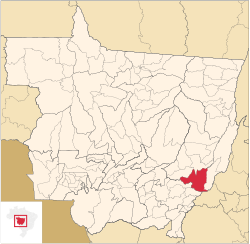 Location in Mato Grosso state | |
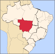
 Barra do Garças Location in Brazil | |
| Coordinates: 15°53′24″S 52°15′24″W / 15.89000°S 52.25667°WCoordinates: 15°53′24″S 52°15′24″W / 15.89000°S 52.25667°W | |
| Country |
|
| Region | Central-West Region |
| State | Mato Grosso |
| Population (2016) | |
| • Total | 58,690 |
| Time zone | BRT-1/BRST-1 (UTC-4/-3) |
Barra do Garças is a city with a population of 50,000 located in the Brazilian state of Mato Grosso, around 550 km (340 mi) far from the capital city of Cuiabá. It was founded on the 13th of June 1924, but it became political independent just on the 15th of September 1948. Nowadays, Barra do Garças is the 8th biggest city in Mato Grosso. It is situated on the border between Mato Grosso and Goiás states and due to this a geodesic center settled down there.
A small but developed tourist city due to high agriculture exportation and a strong military presence, Barra do Garças also has a Cristo Redentor (Christ the Redeemer) and is known as Rio de Janeiro do Oeste (Rio de Janeiro of the West.
Barra do Garças has many tourist attractions: a Discoporto, (UFOport), water parks, as well as hot springs, mountains, and fresh water beaches.

In August, an Italian wind orchestra performed there: the Orchestra Fiati Giovanile Italiana e Coro "I Music Piemonteis" conducted by Ugo Bairo, and his choir, conducted by Carmelo Luca Sambataro. There he performed his wind composition dedicated to the local government, The Mato Grosso March.
The city is served by Barra do Garças Airport.
References
External links
| Wikimedia Commons has media related to Barra do Garças. |
 Barra do Garças travel guide from Wikivoyage
- Video of Orchestra Performance
- Barra do Garças on TV Globo
Capital: Cuiabá | |||||||||||||||||||||||||||||||
| Centro-Sul Mato-Grossense |
|  | |||||||||||||||||||||||||||||
| Nordeste Mato-Grossense |
| ||||||||||||||||||||||||||||||
| Norte Mato-Grossense |
| ||||||||||||||||||||||||||||||
| Sudeste Mato-Grossense |
| ||||||||||||||||||||||||||||||
| Sudoeste Mato-Grossense |
| ||||||||||||||||||||||||||||||