General Carneiro, Mato Grosso
| General Carneiro | |
|---|---|
| Municipality | |
| The Municipality of General Carneiro | |
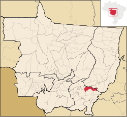 Location of General Carneiro state | |
| Coordinates: 15°42′39″S 52°45′18″W / 15.71083°S 52.75500°WCoordinates: 15°42′39″S 52°45′18″W / 15.71083°S 52.75500°W | |
| Country |
|
| Region | Central-West |
| State |
|
| Founded | November 18, 1958 |
| Government | |
| • Mayor | Juraci Rezende da Cunha (PT) |
| Area | |
| • Total | 3,721.078 km2 (1,436.716 sq mi) |
| Elevation | 343 m (1,125 ft) |
| Population (2012) | |
| • Total | 5,130 |
| • Density | 0.3/km2 (0.8/sq mi) |
| [1] | |
| Time zone | UTC-4 (UTC-4) |
| • Summer (DST) | UTC-3 (UTC-3) |
| HDI (2000) | 0.695 – medium[2] |
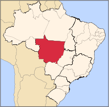
General Carneiro is a municipality in the Brazilian state of Mato Grosso.
References
- ↑ "2012 Populational Estimate" (PDF). Censo Populacional 2012. Instituto Brasileiro de Geografia e Estatística (IBGE). July 2012. Retrieved September 8, 2012.
- ↑ - UNDP
Capital: Cuiabá | |||||||||||||||||||||||||||||||
| Centro-Sul Mato-Grossense |
|  | |||||||||||||||||||||||||||||
| Nordeste Mato-Grossense |
| ||||||||||||||||||||||||||||||
| Norte Mato-Grossense |
| ||||||||||||||||||||||||||||||
| Sudeste Mato-Grossense |
| ||||||||||||||||||||||||||||||
| Sudoeste Mato-Grossense |
| ||||||||||||||||||||||||||||||
This article is issued from Wikipedia - version of the 5/7/2016. The text is available under the Creative Commons Attribution/Share Alike but additional terms may apply for the media files.