Rangely, Colorado
| Town of Rangely, Colorado | |
|---|---|
| Town | |
|
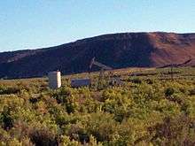
Rangely Museum | |
| Nickname(s): A great place to live | |
 Location in Rio Blanco County and the state of Colorado | |
| Coordinates: 40°5′10″N 108°47′53″W / 40.08611°N 108.79806°WCoordinates: 40°5′10″N 108°47′53″W / 40.08611°N 108.79806°W | |
| Country |
|
| State |
|
| County[1] | Rio Blanco |
| Incorporated (town) | August 27, 1946[2] |
| Government | |
| • Type | Statutory Town[1] |
| • Mayor | Frank Huitt[3] |
| • Town Manager | Peter Brixius[3] |
| Area | |
| • Total | 4 sq mi (10.5 km2) |
| • Land | 4 sq mi (10.5 km2) |
| • Water | 0 sq mi (0 km2) |
| Elevation[4] | 5,297 ft (1,615 m) |
| Population (2000) | |
| • Total | 2,096 |
| • Density | 524/sq mi (199.6/km2) |
| Time zone | Mountain (MST) (UTC-7) |
| • Summer (DST) | MDT (UTC-6) |
| ZIP code[5] | 81648 |
| Area code(s) | 970 |
| FIPS code | 08-62880 |
| GNIS feature ID | 0171670 |
| Website | Town of Rangely |

Rangely is a Statutory Town in Rio Blanco County, Colorado, United States. The population was 2,096 at the 2000 census. The town is home to one of two campuses of the Colorado Northwestern Community College.
A post office called Rangely was established in 1884.[6] The community was named after Rangely, Massachusetts, the native home of a local businessperson.[7]
Geography
Rangely is located at 40°5′10″N 108°47′53″W / 40.08611°N 108.79806°W (40.086181, -108.797944).[8]
According to the United States Census Bureau, the town has a total area of 4.0 square miles (10 km2), all of it land.
The terrain is mountain desert and is dry for most of the year.
Climate
Rangely has a semi-arid climate (Köppen climate classification BSk) with hot summers, cold winters, and uniform precipitation year-round.
| Climate data for Rangely, Colorado (1981–2010 normals) | |||||||||||||
|---|---|---|---|---|---|---|---|---|---|---|---|---|---|
| Month | Jan | Feb | Mar | Apr | May | Jun | Jul | Aug | Sep | Oct | Nov | Dec | Year |
| Record high °F (°C) | 57 (14) |
67 (19) |
78 (26) |
86 (30) |
95 (35) |
108 (42) |
104 (40) |
103 (39) |
98 (37) |
87 (31) |
74 (23) |
60 (16) |
108 (42) |
| Average high °F (°C) | 32.0 (0) |
38.9 (3.8) |
52.9 (11.6) |
62.8 (17.1) |
72.8 (22.7) |
84.3 (29.1) |
91.6 (33.1) |
88.9 (31.6) |
79.2 (26.2) |
65.3 (18.5) |
47.5 (8.6) |
33.0 (0.6) |
62.0 (16.7) |
| Daily mean °F (°C) | 19.0 (−7.2) |
25.8 (−3.4) |
39.3 (4.1) |
47.9 (8.8) |
57.6 (14.2) |
67.5 (19.7) |
74.5 (23.6) |
72.2 (22.3) |
62.5 (16.9) |
49.5 (9.7) |
34.5 (1.4) |
20.8 (−6.2) |
47.3 (8.5) |
| Average low °F (°C) | 5.6 (−14.7) |
12.6 (−10.8) |
25.6 (−3.6) |
33.3 (0.7) |
42.1 (5.6) |
50.8 (10.4) |
57.5 (14.2) |
55.6 (13.1) |
45.7 (7.6) |
33.7 (0.9) |
21.7 (−5.7) |
8.8 (−12.9) |
32.3 (0.2) |
| Record low °F (°C) | −37 (−38) |
−32 (−36) |
−17 (−27) |
−6 (−21) |
8 (−13) |
30 (−1) |
39 (4) |
24 (−4) |
22 (−6) |
1 (−17) |
−15 (−26) |
−29 (−34) |
−37 (−38) |
| Average precipitation inches (mm) | 0.52 (13.2) |
0.57 (14.5) |
0.91 (23.1) |
1.12 (28.4) |
1.14 (29) |
0.91 (23.1) |
0.80 (20.3) |
0.94 (23.9) |
1.40 (35.6) |
1.36 (34.5) |
0.85 (21.6) |
0.61 (15.5) |
10.57 (268.5) |
| Average precipitation days (≥ 0.01 in) | 5 | 5 | 6 | 7 | 7 | 5 | 5 | 7 | 7 | 6 | 5 | 5 | 68 |
| Source: NOAA (extremes 1938–present)[9] | |||||||||||||
Demographics
| Historical population | |||
|---|---|---|---|
| Census | Pop. | %± | |
| 1950 | 808 | — | |
| 1960 | 1,464 | 81.2% | |
| 1970 | 1,591 | 8.7% | |
| 1980 | 2,113 | 32.8% | |
| 1990 | 2,278 | 7.8% | |
| 2000 | 2,096 | −8.0% | |
| 2010 | 2,365 | 12.8% | |
| Est. 2015 | 2,381 | [10] | 0.7% |
As of the 2000 census,[12] there were 2,096 people, 749 households, and 546 families residing in the town. The population density was 518.4 people per square mile (200.3/km²). There were 899 housing units at an average density of 222.4 per square mile (85.9/km²). The racial makeup of the town was 94.42% White, 0.43% African American, 1.05% Native American, 0.43% Asian, 1.62% from other races, and 2.05% from two or more races. Hispanic or Latino of any race were 5.20% of the population.
There were 749 households out of which 41.4% had children under the age of 18 living with them, 57.5% were married couples living together, 10.1% had a female householder with no husband present, and 27.1% were non-families. 23.4% of all households were made up of individuals and 6.3% had someone living alone who was 65 years of age or older. The average household size was 2.59 and the average family size was 3.05.
In the town the population was spread out with 28.3% under the age of 18, 14.4% from 18 to 24, 29.6% from 25 to 44, 20.5% from 45 to 64, and 7.3% who were 65 years of age or older. The median age was 31 years. For every 100 females there were 104.5 males. For every 100 females age 18 and over, there were 103.4 males.
The median income for a household in the town was $41,276, and the median income for a family was $48,438. Males had a median income of $41,220 versus $25,242 for females. The per capita income for the town was $17,668. About 6.3% of families and 9.8% of the population were below the poverty line, including 10.2% of those under age 18 and 4.1% of those age 65 or over.
Historic places
Near Rangely are the following prehistoric Fremont culture sites listed as National Register of Historic Places:[13]
- Prehistoric sites
- Collage Shelter Site – dated from 500–1499 AD.
- Cañon Pintado – dated from 500–1899 AD.
- Carrot Men Pictograph Site – dated from 500–1499 AD.
- Fremont Lookout Fortification Site – dated from 0–1499 AD.
References
- 1 2 "Active Colorado Municipalities". State of Colorado, Department of Local Affairs. Retrieved September 1, 2007.
- ↑ "Colorado Municipal Incorporations". State of Colorado, Department of Personnel & Administration, Colorado State Archives. December 1, 2004. Retrieved September 2, 2007.
- 1 2 http://www.rangely.com/
- ↑ http://www.rangely.com/FAQGeneral.html
- ↑ "ZIP Code Lookup" (JavaScript/HTML). United States Postal Service. Retrieved December 19, 2007.
- ↑ "Post offices". Jim Forte Postal History. Retrieved 8 July 2016.
- ↑ Dawson, John Frank. Place names in Colorado: why 700 communities were so named, 150 of Spanish or Indian origin. Denver, CO: The J. Frank Dawson Publishing Co. p. 43.
- ↑ "US Gazetteer files: 2010, 2000, and 1990". United States Census Bureau. February 12, 2011. Retrieved April 23, 2011.
- ↑ "NowData - NOAA Online Weather Data". National Oceanic and Atmospheric Administration. Retrieved May 30, 2016.
- ↑ "Annual Estimates of the Resident Population for Incorporated Places: April 1, 2010 to July 1, 2015". Retrieved July 2, 2016.
- ↑ "Census of Population and Housing". Census.gov. Retrieved June 4, 2015.
- ↑ "American FactFinder". United States Census Bureau. Retrieved January 31, 2008.
- ↑ National Register of Historic Places in Rio Blanco County American Dreams, Inc. Retrieved October 6, 2011.
External links
Municipalities and communities of Rio Blanco County, Colorado, United States | ||
|---|---|---|
| Towns | 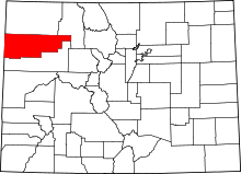 | |
| Unincorporated community | ||
