List of secondary highways in Timiskaming District
This is a list of secondary highways in Timiskaming District, most of which serve as logging roads or provide access to the isolated and sparsely populated areas in the Timiskaming District of northeastern Ontario.
Highway 558
| |
|---|---|
| Route information | |
| Maintained by the Ministry of Transportation of Ontario | |
| Length: | 20 km[1] (10 mi) |
| Major junctions | |
| West end: | Montreal River |
| East end: | Mowat Landing Rd./Firstbrook Line Rd. at the city limits of Temiskaming Shores |
| Location | |
| Divisions: | Timiskaming District |
| Major cities: | Button's Corners, Mowat Landing |
| Highway system | |

Secondary Highway 558, commonly referred to as Highway 558, is a secondary highway in the Canadian province of Ontario. Located in the Timiskaming District, the highway begins at the western city limits of Temiskaming Shores, three kilometres west of Highway 11 along Mowat Landing Road. It extends westerly for 20 kilometres (12 mi), passing through the community of Button's Corners and ending at the Montreal River in the community of Mowat Landing. Some cottages and a public boat launch are at the western terminus.
Highway 562
| ||||
|---|---|---|---|---|
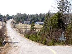
| Main Street (Thornloe) | ||||
| Route information | ||||
| Maintained by the Ministry of Transportation of Ontario | ||||
| Length: | 14.5 km[1] (9.0 mi) | |||
| Major junctions | ||||
| Southwest end: |
| |||
|
| ||||
| Northeast end: |
| |||
| Location | ||||
| Districts: | Timiskaming District | |||
| Major cities: | Kerns, Armstrong | |||
| Highway system | ||||
| ||||

Secondary Highway 562, commonly referred to as Highway 562, is a secondary highway in the Canadian province of Ontario. Located in the Timiskaming District, the highway begins at an intersection with Highway 65 at McCool. It extends northerly for 3 kilometres (1.9 mi), and then turns easterly for 12 kilometres (7.5 mi), ending at a junction with Highway 11 just outside Thornloe.
Highway 564
Highway 566
Highway 567
| ||||
|---|---|---|---|---|
| Route information | ||||
| Maintained by the Ministry of Transportation of Ontario | ||||
| Length: | 38.3 km[1] (23.8 mi) | |||
| Major junctions | ||||
| South end: | Montreal River and Matabitchuan River | |||
| North end: | King Street in North Cobalt | |||
| Location | ||||
| Districts: | Timiskaming District | |||
| Highway system | ||||
| ||||

Secondary Highway 567, commonly referred to as Highway 567, is a secondary highway in the Canadian province of Ontario, located within Timiskaming District. Commencing at a junction with King Street in the community of North Cobalt, the highway extends southerly for 38.3 kilometres (23.8 mi) to the power dams at the mouths of the Montreal River and Matabitchuan River.
Highway 568
| ||||
|---|---|---|---|---|
| Route information | ||||
| Maintained by the Ministry of Transportation of Ontario | ||||
| Length: | 2.4 km[1] (1.5 mi) | |||
| Major junctions | ||||
| West end: | Ontario Highway 11 at Kenogami Lake | |||
| East end: | Kenogami Lake Station | |||
| Location | ||||
| Districts: | Timiskaming District | |||
| Highway system | ||||
| ||||

Secondary Highway 568, commonly referred to as Highway 568, is a secondary highway the Unorganized West Part of Timiskaming District in northwestern Ontario, Canada.[2] Commencing at a junction with Ontario Highway 11 in the community of Kenogami Lake,[1] the highway extends east for 2.4 kilometres (1.5 mi) to the crossing with the Ontario Northland Railway main line at Kenogami Lake Station.
Highway 569
| ||||
|---|---|---|---|---|
| Route information | ||||
| Maintained by the Ministry of Transportation of Ontario | ||||
| Length: | 28.3 km[1] (17.6 mi) | |||
| Major junctions | ||||
| South end: |
| |||
| North end: |
| |||
| Location | ||||
| Districts: | Timiskaming District | |||
| Highway system | ||||
| ||||

Secondary Highway 569, commonly referred to as Highway 569, is a secondary highway in the Canadian province of Ontario. Located within Timiskaming District, the highway spans a distance of 28.3 kilometres (17.6 mi). Commencing at a junction with Highway 11 in the township of Harley, it travels northerly for 19 kilometres (12 mi) through the communities of Couttsville and Hilliardton, then travels west for 9 kilometres (5.6 mi) through the communities of Tomstown and Heaslip to another junction with Highway 11 and Highway 624 in the township of Evanturel southeast of Englehart.

Highway 570
Highway 571
| ||||
|---|---|---|---|---|
| Route information | ||||
| Maintained by the Ministry of Transportation of Ontario | ||||
| Length: | 5.8 km[1] (3.6 mi) | |||
| Major junctions | ||||
| South end: |
| |||
| Highway 640 at Earlton | ||||
| North end: |
| |||
| Location | ||||
| Districts: | Timiskaming District | |||
| Major cities: | Armstrong | |||
| Highway system | ||||
| ||||

Secondary Highway 571, commonly referred to as Highway 571, is a secondary highway in the Canadian province of Ontario. Located in the Timiskaming District, the highway extends from a junction near the midpoint of Highway 562 northerly for 5.8 kilometres (3.6 mi) to a junction with Highway 11 at Earlton.
Highway 573
| ||||
|---|---|---|---|---|
| Route information | ||||
| Length: | 19.7 km[1] (12.2 mi) | |||
| Major junctions | ||||
| South end: |
| |||
| North end: |
| |||
| Location | ||||
| Districts: | Timiskaming District | |||
| Major cities: | Charlton, Ontario | |||
| Highway system | ||||
| ||||

Secondary Highway 573, commonly referred to as Highway 573, is a secondary highway in the Canadian province of Ontario. Its total length is approximately 19.3 kilometres (12.0 mi). Its northern terminus is Highway 11, and its southern terminus is at Highway 560 in Charlton.
Highway 624
| ||||
|---|---|---|---|---|
| Route information | ||||
| Maintained by the Ministry of Transportation of Ontario | ||||
| Length: | 41.9 km[1] (26.0 mi) | |||
| Major junctions | ||||
| South end: |
| |||
| North end: |
| |||
| Location | ||||
| Districts: | Timiskaming District | |||
| Highway system | ||||
| ||||

Secondary Highway 624, commonly referred to as Highway 624, is a secondary highway in the Canadian province of Ontario. Located within Timiskaming District, the highway spans a distance of 42 kilometres from a junction with Highway 11 and Highway 569 in the township of Evanturel to a junction with Highway 66 in Larder Lake, passing through the community of Marter about 10 kilometres (6 mi) north of the south end. Another Highway 624 existed in the 1950s and early 1960s west of Timmins, connecting Highway 616 with Foleyet; Highway 101 eventually assumed this route.
Highway 640
| ||||
|---|---|---|---|---|
| Airport Road | ||||
| Route information | ||||
| Maintained by the Ministry of Transportation of Ontario | ||||
| Length: | 3 km (2 mi) | |||
| Major junctions | ||||
| Southwest end: | Earlton-Timiskaming Regional Airport | |||
| Northeast end: |
| |||
| Location | ||||
| Districts: | Timiskaming District | |||
| Major cities: | Armstrong | |||
| Highway system | ||||
| ||||

Secondary Highway 640, commonly referred to as Highway 640, is a secondary highway in the Canadian province of Ontario, which extends for three kilometres from a junction with Highway 571 in Earlton to the Earlton-Timiskaming Regional Airport. It is two lanes wide and paved in its entirety.[3]
Highway 650
| ||||
|---|---|---|---|---|
| Route information | ||||
| Maintained by the Ministry of Transportation of Ontario | ||||
| Length: | 7.6 km[1] (4.7 mi) | |||
| Existed: | April 1, 1964[4] – present | |||
| Major junctions | ||||
| West end: |
| |||
| East end: | Adams Mine site | |||
| Location | ||||
| Districts: | Timiskaming | |||
| Highway system | ||||
| ||||

Secondary Highway 650, commonly referred to as Highway 650, is a provincially maintained highway in the Canadian province of Ontario. The highway is 7.6 kilometres (4.7 mi) in length, connecting Highway 112 in Dane with the now abandoned Adams Mine site. The route was designated in 1964, shortly after the mine opened. It is sparsely travelled, but paved throughout its length.
References
- 1 2 3 4 5 6 7 8 9 10 Ministry of Transportation of Ontario (2007). "Annual Average Daily Traffic (AADT) counts". Retrieved July 7, 2011.
- ↑ Map 15 (PDF) (Map). 1 : 1,600,000. Official road map of Ontario. Ministry of Transportation of Ontario. 2010-01-01. Retrieved 2011-08-18.
- ↑
- ↑ A.A.D.T. Traffic Volumes 1955–1969 And Traffic Collision Data 1967–1969. Ontario Department of Highways. 1970. p. 145.
