Ontario Highway 622
| ||||
|---|---|---|---|---|
| Bending Lake Road | ||||
| Route information | ||||
| Length: | 130.3 km[1] (81.0 mi) | |||
| History: |
Designated as Highway 807 in 1982 Opened as Highway 622 in 1988 | |||
| Major junctions | ||||
| North end: | Highway 17, 35 km west of Ignace | |||
| South end: | Highway 11B in Atikokan | |||
| Location | ||||
| Counties: | Rainy River, Kenora | |||
| Major cities: | Atikokan, Ignace | |||
| Highway system | ||||
| ||||

Secondary Highway 622, commonly referred to as Highway 622, is a long connecting route between Highways 11 and Highway 17 in Northwestern Ontario. The road is connected to Highway 11 by the 3 km-long spur road Highway 11B in Atikokan.
The road was built through the 1980s, with crews working from Highway 11 and Highway 17, meeting in the middle in 1988. It was opened to traffic in September 1989 and renumbered as Highway 622. During its construction, it was known as Bending Lake Road and was designated as Highway 807.
Route description
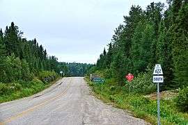
Highway 622 is a long and desolate highway in northwestern Ontario that connects Highway 11 and Highway 17 via Highway 11B. Aside from Atikokan, at the southern end of the route, there are no communities, residences or establishments along the entire 130.3 km (81.0 mi) route. A handful of logging roads branch off the highway, but otherwise no through routes intersect it between its two termini. At its southern end, the route begins by branching off east from Highway 11B as it enters into Atikokan from the south. Highway 622 curves around the east side of the town then proceeds north into the wilderness. Between there and its northern terminus at Highway 17 between Dryden and Ignace, the route passes through a lake dotted region covered by rock and forest; the boreal forest and the Canadian Shield.
History
In 1979, construction began on Bending Lake Road under the Northern Economic Development Program. Contracts were tendered for clearing the route from Highway 17 southerly and the existing Highway 622 northerly, as well as for the grading of 17.5 km (10.9 mi) of the route midway between the two. The southern end of this work was 43 km (27 mi) north of Highway 622. The latter job was completed by the following year. In 1980, work began on grading a new route from the end of an existing development road which branched off of Highway 622 north for 17 km (11 mi), which was completed during the summer of 1981. In 1982, contracts were awarded for grading a 13.1 km (8.1 mi) road north from 60.5 km (37.6 mi) north of Highway 622.[2]
By 1984, the remaining 18 km (11 mi) between the southern and middle sections were graded, and structures completed over the Seine River and Little Turtle River.[3] Contracts were awarded that year for construction of a structure over the Turtle River and for a further 5.5 km (3.4 mi) of grading from 73.6 km (45.7 mi) north of Highway 622 northerly. By the summer of 1985, 77 km (48 mi) of the road was graded and all three major river crossings completed.[4] Contracts were awarded to begin grading the route 9 km (5.6 mi) southerly from Highway 17, and for the installation of guide rails along the completed sections. The former of these two contracts was completed by the following summer, at which point another contract was tendered for grading another 10.6 km (6.6 mi) southward.[5] This was followed in 1987 with a contract for an additional 11.3 km (7.0 mi) of the northern section. Finally, in 1988, three contracts were tendered to complete the highway: the first was to grade the remaining 11.7 km (7.3 mi) of the route; the remaining two were to pave the entire route.[6] The highway was opened in September 1989.
For several years in the late 1990s and early 2000s, the highway became used by trucking traffic as an alternative to Ontario Highway 71, after load restrictions were placed on the Sioux Narrows Bridge.[7]
Major intersections
The following table lists the major junctions along Highway 622. In addition, it includes some minor junctions that are noted by the Ministry of Transportation of Ontario.
| Division | Location | km[1] | Destinations | Notes | |
|---|---|---|---|---|---|
| Rainy River | Atikokan | 0.0 | Highway 11B south (to |
||
| Unorganized Rainy River District | 4.1 | Hardydam Road / Rawn Reservoir Road | |||
| 8.6 | Highway 7177 west (Font Hill Timber Road) | ||||
| 31.6 | Gravel Road (west) Dashwa Lake Road (east) |
||||
| Kenora | Unorganized Kenora District | 69.3 | Sedgewick Lake Road | ||
| 86.0 | Big Turtle River bridge | ||||
| 130.3 | |||||
| 1.000 mi = 1.609 km; 1.000 km = 0.621 mi | |||||
References
- 1 2 Ministry of Transportation of Ontario (2007). "Annual Average Daily Traffic (AADT) counts". Government of Ontario. Retrieved September 11, 2011.
- ↑ 1982 Northern Highway Construction Report
- ↑ 1984 report
- ↑ 1985 report
- ↑ 1986 report
- ↑ 1988 report
- ↑ "Sioux Narrows bridge reopens". Sudbury Star, December 23, 2003.
