Kawartha Lakes Road 49
| ||||
|---|---|---|---|---|
| Route information | ||||
| Maintained by city of Kawartha Lakes | ||||
| Length: | 18.00 km[1] (11.18 mi) | |||
| Major junctions | ||||
| North end: |
| |||
|
| ||||
| South end: |
| |||
| Location | ||||
| Counties: | Kawartha Lakes, Peterborough (road lies on boundary between counties) | |||
| Villages: | Bobcaygeon | |||
| Highway system | ||||
| ||||

Kawartha Lakes Road 49, known locally as East Street North in Bobcaygeon, is a municipally-maintained class-3 roadway (with the exception of a 0.4-kilometre (0.2 mi) class-4 section at the southern end)[2] located in the city of Kawartha Lakes, in the Canadian province of Ontario. The 18-kilometre-long (11 mi) route begins in Bobcaygeon at a junction with former Highway 36, and proceeds north along the boundary between Kawartha Lakes and Peterborough County to a junction with Highway 121 just south of Kinmount.
The route was designated as Highway 500 in 1956. A major renumbering resulted in it becoming Highway 649 in 1964. The route remained generally unchanged until it was decommissioned and transferred to Victoria County at the beginning of 1998; it then became County Road 49. In 2001, Victoria County was restructured as the City of Kawartha Lakes, but the road retained the same number.[3]
Route description
The road runs in a predominantly north–south direction and covers a distance of 18.0 kilometres (11.2 mi).[1][3] The road crosses primarily rural geography[1] between its southern terminus, City Road 36 (Main Street), and northern terminus, City Road 121, with the exception of the village of Bobcaygeon at its southern terminus.[3] The road crosses the boundary between the Ordovician limestone to the south and the granite Canadian Shield to the north, resulting in a hilly landscape with many large rock outcroppings.[1]
History
The road that is now Kawartha Lakes Road 49 started in 1853, when an act of parliament set forth the building of colonization roads into what was then the frontier of Upper Canada. One of the first of these roads was named the Bobcaygeon Road, after the village at its southern end. In 1956, the southern portion of the Bobcaygeon Road through Minden was transferred to the responsibility of the provincial government and numbered as Highway 500.[4] Highway 121 was also opened along the Bobcaygeon Road that year, from south of Kinmount to Minden.[5]
On March 1, 1964, a major renumbering took place in the Kawartha – Haliburton – Peterborough area, which resulted in Highway 500 being renumbered as Highway 649. The road held this designation until January 1, 1998, when the entirety of Highway 649 was decommissioned and transferred to Victoria County,[6] which designated it as Victoria County 49.[7] In 2001, Victoria County was restructured as the city of Kawartha Lakes, and the road was renamed Kawartha Lakes Road 49,[8] which it remains known as today.[3]
Major intersections
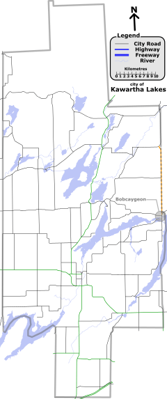
The following table lists the major junctions along Kawartha Lakes Road 49.[1] The entire route is located in Kawartha Lakes.[3]
| Location | km[1] | mi | Destinations | Notes | |
|---|---|---|---|---|---|
| Bobcaygeon | 0.0 | 0.0 | Southern terminus of highway; the road continues south as | ||
| 9.7 | 6.0 | ||||
| 18.0 | 11.2 | Northern terminus of highway | |||
| 1.000 mi = 1.609 km; 1.000 km = 0.621 mi | |||||
See also
List of numbered roads in Kawartha Lakes, Ontario
References
- 1 2 3 4 5 6 Google (November 22, 2009). "Kawartha Lakes Road 49 (length and route)" (Map). Google Maps. Google. Retrieved November 22, 2009.
- ↑ city of Kawartha Lakes, Kawartha Lakes winter maintenance priorities schedule (PDF), retrieved October 11, 2009
- 1 2 3 4 5 Ontario Back Road Atlas (Map). MapArt. 2010. ISBN 978-1-55198-226-7.
- ↑ "Ontario Secondary Roads Now Designated 500, 600". 112 (33,119). The Globe and Mail. February 4, 1956. p. 4.
Two new Ontario road numbers appear on the province's 1956 official road map which will be ready for distribution next week. The new numbers are the 500 and 600 series and designate hundreds of miles of secondary roads which are wholly maintained by the Highways Department. More than 100 secondary roads will have their own numbers and signs this year. All of these secondary roads were taken into the province's main highways system because they form important connecting links with the King's Highways
- ↑ Ontario Road Map (Map). Cartography by C.P. Robins. Ontario Department of Highways. 1956. § O31.
- ↑ Highway Transfers List - “Who Does What” (Report). Ministry of Transportation of Ontario. June 20, 2001. pp. 12, 15.
- ↑ Kawartha / Haliburton Highlands (Map). MapArt. 1999. ISBN 1-55368-335-8.
- ↑ Kitchen, Harry (April 19, 2000). Municipal Government for Victoria County: A New Beginning—Final Report and Order (PDF) (Report). Government of Ontario. pp. 35–36. Retrieved January 16, 2010.