North Smithfield, Rhode Island
| North Smithfield, Rhode Island | |
|---|---|
| Town | |
|
Forestdale school house from the nineteenth century | |
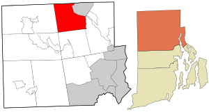 Location in Providence County and the state of Rhode Island. | |
| Coordinates: 41°59′17″N 71°33′7″W / 41.98806°N 71.55194°W | |
| Country | United States |
| State | Rhode Island |
| County | Providence |
| Government | |
| • Town Administrator | Paulette D. Hamilton |
| • Town Council |
Paul J. Zwolenski Robert P. Boucher Kimberly L. Alves Roseanne Nadeau Ernest H. Alter |
| Area | |
| • Total | 24.7 sq mi (64.1 km2) |
| • Land | 24.0 sq mi (62.3 km2) |
| • Water | 0.7 sq mi (1.8 km2) |
| Elevation | 361 ft (110 m) |
| Population (2015) | |
| • Total | 12,314 |
| • Density | 498.6/sq mi (192.1/km2) |
| Time zone | Eastern (EST) (UTC-5) |
| • Summer (DST) | EDT (UTC-4) |
| ZIP codes | 02824, 02896 |
| Area code(s) | 401 |
| FIPS code | 44-52480[1] |
| GNIS feature ID | 1219815[2] |
| Website | http://www.nsmithfieldri.org/ |

North Smithfield is a town in Providence County, Rhode Island, United States, settled as a farming community in 1666 and incorporated into its present form in 1871. North Smithfield includes the historic villages of Forestdale, Primrose, Waterford, Branch Village, Union Village, Park Square, and Slatersville. The population was 11,967 at the 2010 census.
Geography
According to the United States Census Bureau, the town has a total area of 24.7 square miles (64 km2), of which, 24.0 square miles (62 km2) of it is land and 0.7 square miles (1.8 km2) of it (2.83%) is water. North Smithfield is in a New England upland region. The Branch River and Blackstone Rivers provided much of the power for the early mills in the town.
History
In the 17th century British colonists settled in North Smithfield developing a farming community that they named after Smithfield, London in England.[3] The town was part of Smithfield, Rhode Island until it was incorporated as North Smithfield in 1871.[3] The first colonization occurred after a Native American, "William Minnian, (or Quashawannamut) "of Punkkupage" (present day Canton, MA) of Massachusetts Bay on May 14, 1666, deeded approximately 2,000 acres" to John Mowry and Edward Inman who partnered with Nathaniel Mowry, John Steere, and Thomas Walling in dividing up the purchased tract.[3] In the early 18th century, a Quaker colony developed in what is now North Smithfield (then Smithfield), which extended into south Uxbridge, Massachusetts.
Today North Smithfield is part of the John H. Chaffee Blackstone River Valley National Heritage Corridor. The Blackstone Valley is the oldest industrialized region in the U.S. A local North Smithfield industry today, Berroco Yarns, is a continuation of an original family owned woolen company first established in this valley by Daniel Day in 1809.

The village of Slatersville was largely built by Samuel Slater and his brother John Slater beginning in 1803.[4] It is a well-preserved original New England mill village with worker housing and commercial buildings and a church on a village green. This village is in fact America's first planned industrial mill village.[5] Samuel and John's family owned this mill and the village until the turn of the 20th century.[4]
Union Village, along Rhode Island Route 146A achieved local prominence as an important stagecoach stop on the route along Great Road.[5] Union Village was also home to a hat shop, taverns, an academy and the Union Bank from which the village got its name.[5]
In the nineteenth and early twentieth-century, North Smithfield "was served by several trolley and railroad lines; now all are gone save one. A freight-only spur line of the Providence and Worcester Railroad extends from the main line in Woonsocket and terminates [in Slatersville] at the Providence Pike"[6] where it "primarily serves a single customer, a steel supplier called Denman and Davis,"[7] a company in Slatersville which is now part of O’Neal Steel, Inc...[8]
Demographics
| Historical population | |||
|---|---|---|---|
| Census | Pop. | %± | |
| 1870 | 3,052 | — | |
| 1880 | 3,088 | 1.2% | |
| 1890 | 3,173 | 2.8% | |
| 1900 | 2,422 | −23.7% | |
| 1910 | 2,699 | 11.4% | |
| 1920 | 3,200 | 18.6% | |
| 1930 | 3,945 | 23.3% | |
| 1940 | 4,196 | 6.4% | |
| 1950 | 5,726 | 36.5% | |
| 1960 | 7,632 | 33.3% | |
| 1970 | 9,349 | 22.5% | |
| 1980 | 9,972 | 6.7% | |
| 1990 | 10,497 | 5.3% | |
| 2000 | 10,618 | 1.2% | |
| 2010 | 11,967 | 12.7% | |
| Est. 2015 | 12,314 | [9] | 2.9% |
As of the census[1] of 2000, there were 10,618 people, 3,954 households, and 2,957 families residing in the town. The population density was 441.7 people per square mile (170.5/km²). There were 4,070 housing units at an average density of 169.3 per square mile (65.4/km²). The racial makeup of the town was 98.32% White, 0.42% African American, 0.21% Native American, 0.52% Asian, 0.08% from other races, and 0.45% from two or more races. Hispanic or Latino of any race were 0.47% of the population. 41% reported either French or French Canadian ancestry, 12% Irish, 12% Italian, and 8% English.[12]

There were 3,954 households out of which 31.0% had children under the age of 18 living with them, 64.0% were married couples living together, 7.8% had a female householder with no husband present, and 25.2% were non-families. 21.3% of all households were made up of individuals and 12.4% had someone living alone who was 65 years of age or older. The average household size was 2.61 and the average family size was 3.05.
In the town the population was spread out with 22.4% under the age of 18, 5.7% from 18 to 24, 27.2% from 25 to 44, 26.8% from 45 to 64, and 18.0% who were 65 years of age or older. The median age was 42 years. For every 100 females there were 90.4 males. For every 100 females age 18 and over, there were 86.8 males.
The median income for a household in the town was $58,602, and the median income for a family was $67,331. Males had a median income of $43,133 versus $30,748 for females. The per capita income for the town was $25,031. About 1.9% of families and 3.5% of the population were below the poverty line, including 2.8% of those under age 18 and 9.9% of those age 65 or over.
Historic Places in North Smithfield

- Slatersville, America's first industrial mill village, established by John Slater and Samuel Slater in 1807
- Smithfield Friends Meeting House, Parsonage & Cemetery 18th-19th century Quaker community
- Peleg Arnold Tavern (1690)
- Blackstone Valley National Heritage Corridor
- Forestdale Mill Village Historic District
- Tyler Mowry House (1825)
- William Mowry House (1804)
- Smithfield Road Historic District
- Three Dog Site, RI-151
- Todd Farm (1740)
- Union Village Historic District
Notable people

- Peleg Arnold, delegate to the Continental Congress (1787–1788); Chief Justice of the Rhode Island Supreme Court (1795-1812)[13]
- Joe Connolly, outfielder for the Boston Braves (1913-1916)
- Henry Hobbs, football player and coach[14]
- Jeff Jillson, international hockey defensman
- Tim McNamara, Boston Braves and New York Giants pitcher (1922-1926) died in North Smithfield
- David Rawlings, musician; guitarist with wife Gillian Welch[15]
- R. E. Streeter, Christian writer; founder of the Pastoral Bible Institute in 1918
Education
- North Smithfield High School, the only public high school in the town, was ranked 5th out of 51 public high schools in Rhode Island in 2016.[16]
- North Smithfield Elementary School which was built in 1989 and now is used for grades Preschool-Third Grade.
- The Kendall Dean School was built in 1936 but today is no longer used as a school.
- Dr. Harry L. Halliwell School was built in 1958 and is still used today for grades 3-5. Before it became a school, it was a sheep farm.
- North Smithfield Middle School was built for the 2009-2010 school year which now holds grades 6-8.
Adjacent Cities and Towns
 |
Uxbridge, Massachusetts | Millville, Massachusetts | Blackstone, Massachusetts | |
| Burrillville | |
Woonsocket and Cumberland | ||
| ||||
| | ||||
| Glocester | Lincoln |
Houses of Worship
- Lighthouse Christian Church
- Masjid Al-Islam mosque
- Slatersville Congregational Church
- St. John the Evangelist Church
References
- 1 2 "American FactFinder". United States Census Bureau. Retrieved 2008-01-31.
- ↑ "US Board on Geographic Names". United States Geological Survey. 2007-10-25. Retrieved 2008-01-31.
- 1 2 3 Nebiker, Walter (1976). the History of North Smithfield. Somersworth, NH: New England History Press.
- 1 2 "Samuel Slater/The Mill Village, Slatersville/Woonsocket". Woonsocket.org. Retrieved 2007-12-26.
- 1 2 3 "Plan your visit/Valley sites/Cumberland, North Smithfield, Smithfield". National Park Service. Retrieved 2007-12-25.
- ↑ North Smithfield Comprehensive Plan Five-Year Update Revised August 2007 J - Circulation –March 2006 http://www.nsmithfieldri.org/_resources/common/userfiles/file/Planning/Circulation.pdf
- ↑ Frank Heppner, Railroads of Rhode Island: Shaping the Ocean State's Railways (The History Press, 2012) pg. 81
- ↑ http://onealind.com/121-year-old-metals-service-center-gest-new-identity/
- ↑ "Annual Estimates of the Resident Population for Incorporated Places: April 1, 2010 to July 1, 2015". Retrieved July 2, 2016.
- ↑ "Census of Population and Housing". Census.gov. Retrieved June 4, 2016.
- ↑ Snow, Edwin M. (1867). Report upon the Census of Rhode Island 1865. Providence, RI: Providence Press Company.
- ↑ http://www.epodunk.com/cgi-bin/genealogyInfo.php?locIndex=13444
- ↑ Who Was Who in America, Historical Volume, 1607-1896. Chicago: Marquis Who's Who. 1963.
- ↑ "Obituary Record of Graduates of Yale University Deceased during the Year 1930-1931" (PDF). Bulletin of Yale University. December 1, 1931.
- ↑ Wilkinson, Alec (2004-09-20). "The Ghostly Ones". The New Yorker. p. 78. Retrieved 2009-05-03.
- ↑ Alphabetical List of Public Schools In Rhode Island
External links
 North Smithfield travel guide from Wikivoyage
- The Church on the Green at Slatersville, long a Buxton Church
- Samuel Slater, Father of the American industrial revolution, Slatersville, the mill village/with photos
Image gallery
 Mowry House ca. 1690, on Providence Pike in North Smithfield
 Albert Mowry farmhouse in North Smithfield in the 19th century
North Smithfield in the 19th century Rustic Drive In Movie Theater (1951) in North Smithfield, the last drive in surviving in the state
Municipalities and communities of Providence County, Rhode Island, United States | ||
|---|---|---|
| Cities |  | |
| Towns | ||
| Villages | ||
Providence (capital) | |
| Topics |
|
| Society |
|
| Regions | |
| Cities | |
| Towns |
|
Coordinates: 41°58′00″N 71°32′58″W / 41.96667°N 71.54944°W