Middletown, Rhode Island
| Middletown, Rhode Island | |
|---|---|
| Town | |
|
St. George's School, Middletown, Rhode Island | |
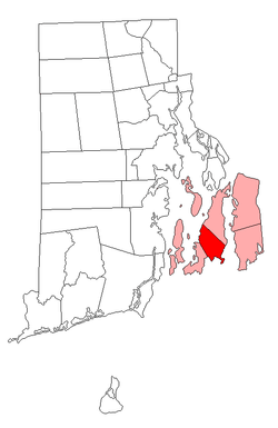 Location of Middletown in Newport County, Rhode Island | |
| Coordinates: 41°30′42″N 71°17′12″W / 41.51167°N 71.28667°W | |
| Country | United States |
| State | Rhode Island |
| County | Newport |
| Incorporated | 1743 |
| Government | |
| • Town Council |
Robert Kempenaar, II (D) M. Theresa Santos (R) Robert J. Sylvia (D) Barbara A. Vonvillas (I) Henry F. Lombardi, Jr. (D) Paul M. Rodrigues (D) Antone C. Viveiros (R) |
| Area | |
| • Total | 14.9 sq mi (38.7 km2) |
| • Land | 13.0 sq mi (33.6 km2) |
| • Water | 2.0 sq mi (5.1 km2) |
| Elevation | 154 ft (47 m) |
| Population (2010) | |
| • Total | 30,450 |
| • Density | 2,242.3/sq mi (880.7/km2) |
| Time zone | Eastern (EST) (UTC-5) |
| • Summer (DST) | EDT (UTC-4) |
| ZIP codes | 02842 |
| Area code(s) | 401 |
| FIPS code | 44-45460[1] |
| GNIS feature ID | 1220063[2] |
.jpg)
Middletown is a town in Newport County, Rhode Island, United States. The population was 16,150 at the 2010 census. It lies to the south of Portsmouth and to the north of Newport on Aquidneck Island, hence the name "Middletown".
History
Various issues including unjust taxation and a growing population caused the freeholders living in the northern section of Newport to petition the general assembly for independence. As a result of the petition, the land that Middletown occupies was set apart in 1731. The town was incorporated in 1743.[3]
During the 1980s, large sections of East Main Road and West Main Road running through Middletown began to be commercialized, and by the late 1990s, the area had become Aquidneck Island's central business district.
Geography

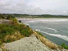
According to the United States Census Bureau, the town has a total area of 14.9 square miles (38.7 km²), of which 13.0 square miles (33.6 km²) is land and 2.0 square miles (5.1 km²; 13.18%) is water. Middletown was known as the "farming community" of Aquidneck Island. Today most of the developed land is located towards the western part of the town, while what is left of its rural heritage is primarily towards the east. Middletown also has several beaches.
Government
The town is governed by a seven-member town council, elected at-large in partisan elections. Executive authority is vested in an appointed town administrator (on the council–manager model). The town also elects a non-partisan school committee.
Middletown forms part of Rhode Island's 1st congressional district, represented by Democrat David Cicilline. At the state level, Middletown is part of one state senate and three state house districts. The 12th Rhode Island Senate district, which also includes parts of Newport, Little Compton and Tiverton, is held by Democrat Louis P. DiPalma. In the Rhode Island House of Representatives, Middletown forms part of the 72nd, 73rd, and 74th districts. The 72nd, which also includes portions of Newport and Portsmouth, is represented by Republican Daniel Reilly. The 73rd, which is predominantly Newport, is held by Democrat Russell Jackson. The 74th, shared between Middletown and Jamestown, is represented by Democrat Deb Ruggiero.
Demographics
| Historical population | |||
|---|---|---|---|
| Census | Pop. | %± | |
| 1790 | 840 | — | |
| 1800 | 913 | 8.7% | |
| 1810 | 976 | 6.9% | |
| 1820 | 949 | −2.8% | |
| 1830 | 915 | −3.6% | |
| 1840 | 891 | −2.6% | |
| 1850 | 830 | −6.8% | |
| 1860 | 1,012 | 21.9% | |
| 1870 | 971 | −4.1% | |
| 1880 | 1,139 | 17.3% | |
| 1890 | 1,154 | 1.3% | |
| 1900 | 1,457 | 26.3% | |
| 1910 | 1,708 | 17.2% | |
| 1920 | 2,004 | 17.3% | |
| 1930 | 2,499 | 24.7% | |
| 1940 | 3,379 | 35.2% | |
| 1950 | 7,382 | 118.5% | |
| 1960 | 12,675 | 71.7% | |
| 1970 | 29,290 | 131.1% | |
| 1980 | 17,216 | −41.2% | |
| 1990 | 19,460 | 13.0% | |
| 2000 | 17,334 | −10.9% | |
| 2010 | 16,150 | −6.8% | |
| Est. 2015 | 16,051 | [4] | −0.6% |
At the 2000 census,[1] there were 17,334 people, 6,993 households and 4,643 families residing in the town. The population density was 1,335.4 per square mile (515.6/km²). There were 7,603 housing units at an average density of 585.7 per square mile (226.2/km²). The racial makeup of the town was 89.12% White, 2.72% African American, 2.36% Native American, 1.18% Asian, 1.11% Pacific Islander, 1.07% from other races, and 2.43% from two or more races. Hispanic or Latino of any race were 2.93% of the population.
There were 6,993 households of which 32.9% had children under the age of 18 living with them, 53.9% were married couples living together, 9.8% had a female householder with no husband present, and 33.6% were non-families. Of all households 28.7% were made up of individuals and 10.9% had someone living alone who was 65 years of age or older. The average household size was 2.43 and the average family size was 3.01.
25.0% of the population were under the age of 18, 6.6% from 18 to 24, 30.9% from 25 to 44, 22.6% from 45 to 64, and 14.9% who were 65 years of age or older. The median age was 38 years. For every 100 females there were 94.8 males. For every 100 females age 18 and over, there were 89.7 males.
The median household income was $51,075 and the median family income was $57,322. Males had a median income of $41,778 and females $27,229. The per capita income for the town was $25,857. About 3.7% of families and 5.0% of the population were below the poverty line, including 6.2% of those under age 18 and 4.7% of those age 65 or over.
Transportation
Newport State Airport, a public-use general aviation airport and the only airport on Aquidneck Island, is located in Middletown.
West Main Road (RI-114) and East Main Road (RI-138) are the main roads running north–south through Middletown.
Sports
Middletown is home to St Columba's Cricket Club, which hosts an annual cricket tournament for teams throughout the New England area. The Newport National Golf Club is located in Middletown. The town is also home to the Middletown Islanders hockey, football, baseball, volleyball, and lacrosse teams. They also are involved with Pop Warner football and cheerleading. More known as a middle school football league, Pop Warner hosts from very young ages and separates them by age.
- Kids ages 6–8: Mighty Mights
- Kids ages 9 & 10: Junior Pee Wee
- Kids ages 11 & 12: Pee Wee
- Kids ages 13 & 14: Midget
Schools
As of September 2009, the Middletown Public School District will consist of four schools serving pre-kindergarten through 12th grade. They are Aquidneck Elementary School (grades pre-K to 3), Forest Avenue Elementary School (grades K–3), Joseph H. Gaudet Middle School (grades 4–8) and Middletown High School (grades 9–12). Starting in September 2009, all fourth grade students will attend Joseph H. Gaudet Middle School. John F. Kennedy, former elementary school, will be closed at the end of the 2008–2009 school year due to budget cuts. Middletown is also home to private schools, including All Saints Academy (grades K–8) and St. George's School (grades 9–12).
Historic sites in Middletown

- Boyd's Windmill, built 1810
- Bailey Farm, built 1838
- Clambake Club of Newport, built in 1895
- Gardiner Pond Shell Midden
- Hamilton Hoppin House, built in 1856
- Lyman C. Joseph House, built 1882
- Paradise School, built 1875
- Prescott Farm, ca. 1715
- Whitehall (Rhode Island), built 1729
- Witherbee School, built 1900
Notable people
- Israel T. Almy, Fall River architect, born in Middletown
- George Berkeley (a.k.a. Bishop Berkeley), 18th century Anglo-Irish philosopher; known for his doctrine of immaterialism; lived in Middletown
- Nicolas Cage, actor, once lived in Middletown
- Billy Cowsill, singer-songwriter, musician and record producer; born in Middletown (1948)
- Charlie Day, actor (It's Always Sunny in Philadelphia); grew up in Middletown
- Michael T. Flynn, former director of the Defense Intelligence Agency, born in Middletown
- Obadiah Holmes, colonial Baptist minister; ancestor of President Abraham Lincoln; lived and is buried in a section of Newport annexed by Middletown
- John Huston, film director, screenwriter and actor (Moulin Rouge (1952), Key Largo); Oscar winner (The Treasure of the Sierra Madre); died in Middletown (1987)
In popular culture
- Portions of the 2012 romantic drama Celeste and Jesse Forever were filmed in several locations throughout the state, notably on Middletown's Sachuest Bay shoreline off Tuckerman Avenue.[7]
References
- 1 2 "American FactFinder". United States Census Bureau. Retrieved 2008-01-31.
- ↑ "US Board on Geographic Names". United States Geological Survey. 2007-10-25. Retrieved 2008-01-31.
- ↑ "Historic and Architectural Resources of Middletown, Rhode Island: A Preliminary Report" (PDF). preservation.ri.gov. Rhode Island Historical Preservation Commission. Retrieved 5 January 2016.
- ↑ "Annual Estimates of the Resident Population for Incorporated Places: April 1, 2010 to July 1, 2015". Retrieved July 2, 2016.
- ↑ "Census of Population and Housing". Census.gov. Retrieved June 4, 2016.
- ↑ Snow, Edwin M. (1867). Report upon the Census of Rhode Island 1865. Providence, RI: Providence Press Company.
- ↑ http://www.imdb.com/title/tt1405365/locations?ref_=tt_dt_dt
External links
| Wikivoyage has a travel guide for Middletown, Rhode Island. |
Municipalities and communities of Newport County, Rhode Island, United States | ||
|---|---|---|
| City | 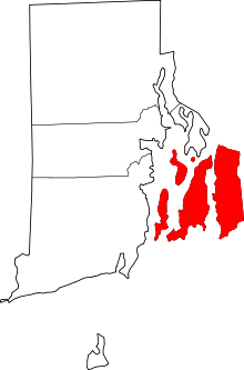 | |
| Towns | ||
| Villages | ||
Providence (capital) | |
| Topics |
|
| Society |
|
| Regions | |
| Cities | |
| Towns |
|
| Islands |  | |
|---|---|---|
| Major rivers | ||
| Cities & towns | ||
| Bridges | ||
Coordinates: 41°32′44″N 71°17′29″W / 41.54556°N 71.29139°W