Foster, Rhode Island
| Foster, Rhode Island | |
|---|---|
| Town | |
 Location in Providence County and the state of Rhode Island. | |
| Coordinates: 41°47′49″N 71°43′38″W / 41.79694°N 71.72722°W | |
| Country | United States |
| State | Rhode Island |
| County | Providence |
| Government | |
| • Type | Town meeting |
| • Town Council |
Denise L. DiFranco (R) John L. Lewis, Jr. (D) Roger L. Hawes (D) Gordon E. Rogers (I) Jon Restivo (D) |
| • Town Moderator | Robert A. Boyden |
| • Town Clerk | Jane Christopher |
| Area | |
| • Total | 51.9 sq mi (134.3 km2) |
| • Land | 51.1 sq mi (132.5 km2) |
| • Water | 0.7 sq mi (1.9 km2) |
| Elevation | 525 ft (160 m) |
| Population (2010) | |
| • Total | 4,606 |
| • Density | 90.1/sq mi (34.8/km2) |
| Time zone | Eastern (EST) (UTC-5) |
| • Summer (DST) | EDT (UTC-4) |
| ZIP code | 02825 |
| Area code(s) | 401 |
| FIPS code | 44-27460[1] |
| GNIS feature ID | 1220072[2] |

Foster is a town in Providence County, Rhode Island, in the United States. The population was 4,606 at the 2010 census.
History
Foster was originally settled in the 17th century by British colonists as a farming community. In the year 1662, William Vaughan, Zachariah Rhodes, and Robert Wescott, purchased of the Indians a large tract of land called West Quanaug, bordering on Providence. The 'West Quanaug purchase', consisted of nearly the whole southern half of the town of Foster. The first settler was allegedly Ezekiel Hopkins. Many settlers from Newport were active in the town in the 18th century. Shortly before the incorporation of the town, Foster's first church, a Calvinist Baptist congregation was founded. Shortly afterwards, Six Principle Baptist and Free Will Baptist congregations were founded.[3]
Foster was incorporated with Scituate, Rhode Island in 1730, forming the western section of that township, and remained part of Scituate until 1781, when it was split off as a distinct and separate township. Foster derived its name, from U.S. Senator Theodore Foster.[4] Mr. Foster presented the town with a library. Some of the library's original books and town records are still preserved. U.S. Senator Nelson Aldrich was born in Foster in 1841. Senator Aldrich was instrumental in starting the U.S. Federal Reserve Board.
In the 1920s the Ku Klux Klan was active in the area, and one of the largest Klan rallies in the state was held in Foster on the Old Home Day grounds in 1924 with 8,000 in attendance and U.S. Senator J. Thomas Heflin of Alabama speaking.[5]
Geography
According to the United States Census Bureau, the town has a total area of 51.9 square miles (134 km2), of which, 51.1 square miles (132 km2) of it is land and 0.7 square miles (1.8 km2) of it (1.41%) is water. Foster contains Rhode Island's highest point, Jerimoth Hill, with an elevation of 248 m (812 ft).
Climate
Climate in this area has mild differences between highs and lows, and there is adequate rainfall year round. According to the Köppen Climate Classification system, Foster has a Oceanic climate, abbreviated "Cfb" on climate maps.[6]
| Climate data for Foster, Rhode Island | |||||||||||||
|---|---|---|---|---|---|---|---|---|---|---|---|---|---|
| Month | Jan | Feb | Mar | Apr | May | Jun | Jul | Aug | Sep | Oct | Nov | Dec | Year |
| Average high °F (°C) | 34 (1) |
38 (3) |
46 (8) |
57 (14) |
67 (19) |
75 (24) |
80 (27) |
78 (26) |
71 (22) |
60.7 (15.9) |
50 (10) |
39 (4) |
57.98 (14.49) |
| Average low °F (°C) | 17 (−8) |
20 (−7) |
27 (−3) |
36 (2) |
46 (8) |
55 (13) |
60 (16) |
59 (15) |
52 (11) |
41 (5) |
32 (0) |
23 (−5) |
39 (3.9) |
| Average precipitation inches (mm) | 4.28 (108.7) |
4.12 (104.6) |
5.45 (138.4) |
4.70 (119.4) |
3.92 (99.6) |
4.58 (116.3) |
3.82 (97) |
4.33 (110) |
4.09 (103.9) |
4.77 (121.2) |
4.96 (126) |
4.84 (122.9) |
53.86 (1,368) |
| Source: Weatherbase [7] | |||||||||||||
Demographics
| Historical population | |||
|---|---|---|---|
| Census | Pop. | %± | |
| 1790 | 2,268 | — | |
| 1800 | 2,457 | 8.3% | |
| 1810 | 2,613 | 6.3% | |
| 1820 | 2,900 | 11.0% | |
| 1830 | 2,672 | −7.9% | |
| 1840 | 2,181 | −18.4% | |
| 1850 | 1,932 | −11.4% | |
| 1860 | 1,935 | 0.2% | |
| 1870 | 1,630 | −15.8% | |
| 1880 | 1,552 | −4.8% | |
| 1890 | 1,252 | −19.3% | |
| 1900 | 1,151 | −8.1% | |
| 1910 | 1,124 | −2.3% | |
| 1920 | 905 | −19.5% | |
| 1930 | 916 | 1.2% | |
| 1940 | 1,237 | 35.0% | |
| 1950 | 1,630 | 31.8% | |
| 1960 | 2,097 | 28.7% | |
| 1970 | 2,626 | 25.2% | |
| 1980 | 3,370 | 28.3% | |
| 1990 | 4,316 | 28.1% | |
| 2000 | 4,274 | −1.0% | |
| 2010 | 4,606 | 7.8% | |
| Est. 2015 | 4,698 | [8] | 2.0% |
Foster's Capt. Isaac Paine Elementary School, has the top spot for reading proficiency according to the New England Common Assessment Program, or NECAP, exams. 82 percent of its students attained proficiency, the state leader in that testing category.
As of the census[1] of 2000, there were 4,274 people, 1,535 households, and 1,198 families residing in the town. The population density was 83.6 people per square mile (32.3/km²). There were 1,578 housing units at an average density of 30.9 per square mile (11.9/km²). The racial makeup of the town was 97.26% White, 0.21% African American, 0.23% Native American, 0.58% Asian, 0.09% Pacific Islander, 0.26% from other races, and 1.36% from two or more races. Hispanic or Latino of any race were 0.80% of the population. Foster's zip code, 02825, has a significantly larger population than the town of Foster. This is because the zip code extends into parts of the more populated town of Scituate, Rhode Island.
There were 1,535 households out of which 36.0% had children under the age of 18 living with them, 68.5% were married couples living together, 6.8% had a female householder with no husband present, and 21.9% were non-families. 17.1% of all households were made up of individuals and 6.3% had someone living alone who was 65 years of age or older. The average household size was 2.77 and the average family size was 3.14.
In the town the population was spread out with 25.9% under the age of 18, 5.6% from 18 to 24, 29.1% from 25 to 44, 28.9% from 45 to 64, and 10.5% who were 65 years of age or older. The median age was 40 years. For every 100 females there were 99.6 males. For every 100 females age 18 and over, there were 97.6 males.
The median income for a household in the town was $59,673, and the median income for a family was $63,657. Males had a median income of $39,808 versus $30,632 for females. The per capita income for the town was $22,148. About 1.5% of families and 3.4% of the population were below the poverty line, including 2.9% of those under age 18 and 7.8% of those age 65 or over.
Arts and culture
Tourism
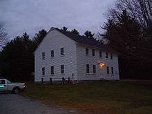
Foster is home to the Foster Town House. Built in 1796 and in use to this day,[11] the Foster Town House is the oldest government meeting house of its type in the United States.[12] Foster also contains both of Rhode Island's only two covered bridges, known as the Swamp Meadow Covered Bridge (the other is located on Ponaganset High School's Cross Country Course). Built in 1994 by Jed Dixon, a Foster resident, it is a reproduction of an early-19th-century specimen. It is the only covered bridge in Rhode Island located on a public road.[13][14] Jerimoth Hill, the highest point of elevation in Rhode Island, is located in Foster.[15]
Parks and recreation
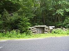
Foster is home to the most scenic part of the North-South Trail. Along the trail you can see the remnants of the Thomas O' Wagon Wheel Shop which was later converted to a shingle mill in 1919.
Notable people
- Nelson Aldrich, US senator from Rhode Island; father of Abby Rockefeller; born in Foster[16]
- Solomon Drowne, physician and author; confidante of Theodore Foster; lived in Foster on a farm named Mount Hygeia
- Theodore Foster, US senator from Rhode Island; the town of Foster is named after him[17]
- H. P. Lovecraft, author; lived on Johnson Road in Foster
Historic Places in Foster
- Foster Center Historic District
- Breezy Hill Site (RI-957)
- Clayville Historic District
- Capt. George Dorrance House (1720)
- Moosup Valley Historic District
- Mount Vernon Tavern (1761)
- Mt. Hygeia (1808)
References
- 1 2 "American FactFinder". United States Census Bureau. Retrieved 2008-01-31.
- ↑ "US Board on Geographic Names". United States Geological Survey. 2007-10-25. Retrieved 2008-01-31.
- ↑ Albert J. Wright (1878). History of the State of Rhode Island with Illustrations. Philadelphia: Printer No. 79 Mille Street, corner of Federal, Boston. Hong, Wade & Co. pp. 133–135.
- ↑ Gannett, Henry (1905). The Origin of Certain Place Names in the United States. Govt. Print. Off. p. 130.
- ↑ http://www.projo.com/specials/century/month4/426nw1.htm
- ↑ Climate Summary for Foster, Rhode Island
- ↑ "Weatherbase: Historical Weather for Foster, Rhode Island". Weatherbase. 2011. Retrieved on November 24, 2011.
- ↑ "Annual Estimates of the Resident Population for Incorporated Places: April 1, 2010 to July 1, 2015". Retrieved July 2, 2016.
- ↑ "Census of Population and Housing". Census.gov. Retrieved June 4, 2016.
- ↑ Snow, Edwin M. (1867). Report upon the Census of Rhode Island 1865. Providence, RI: Providence Press Company.
- ↑ "Historical Preservation". The Town of Foster Rhode Island. Retrieved April 2, 2014.
- ↑ "Rhode Island". Good Sam Camping. Retrieved April 2, 2014.
- ↑ "Swamp Meadow Covered Bridge". Visit Rhode Island. Retrieved April 2, 2014.
- ↑ "Swamp Meadow Covered Bridge". VisitNewEngland.com. Retrieved April 2, 2014.
- ↑ "JERIMOTH HILL". Atlas Obscura. Retrieved April 2, 2014.
- ↑ "ALDRICH, Nelson Wilmarth, (1841 - 1915)". Biographical Directory of the United States Congress. Retrieved March 26, 2014.
- ↑ "Theodore Foster Papers". Rhode Island Historical District. Retrieved April 2, 2014.
External links
| Wikimedia Commons has media related to Foster, Rhode Island. |
- Foster History
- Town of Foster, RI
- Foster Preservation Society
- South Foster Volunteer Fire Company
- City-Data.com
Municipalities and communities of Providence County, Rhode Island, United States | ||
|---|---|---|
| Cities | 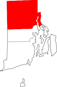 | |
| Towns | ||
| Villages | ||
Providence (capital) | |
| Topics |
|
| Society |
|
| Regions | |
| Cities | |
| Towns |
|
Coordinates: 41°51′13″N 71°45′29″W / 41.85361°N 71.75806°W