East Greenwich, Rhode Island
| East Greenwich, Rhode Island | |
|---|---|
| Town | |
|
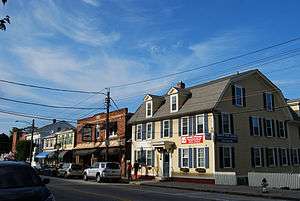
Historic District in downtown East Greenwich | |
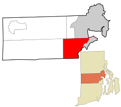 Location in Kent County and the state of Rhode Island. | |
| Coordinates: 41°39′N 71°29′W / 41.650°N 71.483°WCoordinates: 41°39′N 71°29′W / 41.650°N 71.483°W | |
| Country | United States |
| State | Rhode Island |
| County | Kent |
| Incorporated | 1677 |
| Government | |
| • Type | Town Council and Manager |
| • Town Council |
Michael B. Isaacs (R) Mark Schwager (D) Suzanne M. Cienki (R) Sean M. Todd (R) William C. Stone (D) |
| • Town Moderator | Arthur Chuck Barton, III (R) |
| • Manager | Thomas E. Coyle, III |
| Area | |
| • Total | 16.71 sq mi (43.3 km2) |
| • Land | 16.58 sq mi (42.9 km2) |
| • Water | 0.14 sq mi (0.4 km2) |
| Elevation | 200 ft (61 m) |
| Population (2010) | |
| • Total | 13,146 |
| • Density | 792.9/sq mi (306.1/km2) |
| Time zone | Eastern (EST) (UTC-5) |
| • Summer (DST) | EDT (UTC-4) |
| ZIP code | 02818 |
| Area code(s) | 401 |
| FIPS code | 44-22240[1] |
| GNIS feature ID | 1220085[2] |
| Website | www.eastgreenwichri.com |
East Greenwich is an affluent town in the county seat of Kent County, Rhode Island, United States.[3] The population was 13,146 at the 2010 census. East Greenwich is the wealthiest municipality within the state of Rhode Island.
Formed as Greenwich in 1677, it was named for Greenwich, England.[4] It was renamed Dedford in 1686 but reverted to its original name in 1689. In 1741 the more rural western three-quarters of the town was set off as West Greenwich, the remaining quarter of it thenceforth being called East Greenwich. Until 1854, it was one of the five state capitals for Rhode Island. The General Assembly, when meeting in East Greenwich, used the local courthouse, which is today the town hall. East Greenwich Village is located in the northeastern part of the town and extends north about 1.5 km into the town of Warwick, Rhode Island. The town is now known for its waterfront and downtown business district.
History
East Greenwich was founded in 1677 by the General Assembly in an attempt to solidify land claims against those of Connecticut and the Narragansett Proprietors. The Assembly designated 5000 acres to the new town and provided lots to settlers who would agree to live there. Locals quickly took the assembly up on this offer, and the quick establishment of the town helped hold back plans of Connecticut in pushing their border eastward.[5] East Greenwich was therefore the only Rhode Island town established by an act of government, not commercial interests.[6] In 1687, the Narragansett Proprietors attempted to settle land north of Wickford which overlapped with the land of East Greenwich; however, the Massachusetts governor Sir Edmund Andros, who had authority to settle the dispute, ruled in favor of the existing East Greenwich settlement.
In the 18th century, the government released previously reserved waterfront property in small lots. Beginning in 1711, the local government granted these lots to any person who would pay one shilling and promise to build a commercial building of a minimum size. By 1725, a community had developed, complete with a schoolhouse and a graveyard. However, citizens of the town complained that attending town meetings was too difficult due to the size of the town, which prompted the splitting of West Greenwich into its own town in 1741. The town erected a courthouse when East Greenwich was designated the shire town of the newly formed Kent County, which had been separated from Providence County in 1750.
In its colonial days, the town was also home to followers of Jemima Wilkinson, an ex-Quaker who later defected to the New Light Baptists. After she suffered from a severe illness, Wilkinson believed that she had died and that her body was now possessed by an entity which she called the "Publick Universal Friend". Her followers financed a meetinghouse within the town.[6]
Geography
20 percent of the land in East Greenwich consists of undeveloped woods and farmland, although development continues to bring this proportion down.[7]
Schools
East Greenwich is home to six public schools in its school district. The district contains two zoning districts for its elementary schools. Students in one district, which primarily consists of households east of South County Trail, attend Meadowbrook Farms Elementary from kindergarten to second grade, then proceed to George R. Hanaford School for third grade to fifth grade. Most students who live west of South County Trail will attend Frenchtown Elementary for kindergarten to second grade before attending James H. Eldredge School for third grade to fifth grade.[8] All students in the public school district then attend Archie R. Cole Middle School for sixth grade to eighth grade. The district's single high school is East Greenwich High School.
The town also contains the Our Lady Of Mercy Regional School, a private Catholic school serving students from pre-kindergarten to eighth grade. East Greenwich was also home to the East Greenwich Academy, an eminent preparatory school; however, the school closed in 1943.
Waterfront
Many restaurants, bars, and clubs sit on the waterfront. East Greenwich Cove also has ample boat parking. There is also a public dock good for fishing and eating, and a dock with a small beach. Across from the coast is Goddard Memorial State Park, which has many beaches including Sandy Point and has easy access from East Greenwich Cove.
Scalloptown Park has been completed at the southern end of Greenwich Cove, built atop the old town landfill.[9] However, it is not part of historical Scalloptown, which was another name for the waterfront in earlier times. Home to a poor community of squatters in the late nineteenth century to the earliest twentieth century, Scalloptown became a community untethered from the rest of East Greenwich.[10] In contrast to the other villages in East Greenwich, Scalloptown consisted primarily of poor whites and African Americans. The true Scalloptown goes from the town dock down past the clubs to Fin's Marina.
Legend of The Greenwich Voyager
In the Spring of 1791, US Navy Captain Joseph Jonathan (of Providence, Rhode Island) and his crew captured a group of high-class extortionists attempting to flee the United States. According to the Legend, Jonathan defected from his post upon returning from the battle and made off with almost 18,000 oz. of 21K gold. Without the evidence stolen by Jonathan, the extortionists were released from police custody. The events that followed are still unclear, but Jonathan was discovered dead in his home alongside all 7 members of the extortionist crew. According to the legend; the gold, which today would be valued at $19.5 million, is buried somewhere in the Frenchtown area, where Jonathan lived. His home was located inside of Goddard Memorial State Park in the North Eastern section, and it is believed by some that a description of the location of the gold is in that general vicinity. The legend warns that if the gold, which the town of East Greenwich is literally built upon, is moved, the town will crumble and all who live in it will turn against he who unearthed the gold.[11][12]
Demographics
| Historical population | |||
|---|---|---|---|
| Census | Pop. | %± | |
| 1790 | 1,824 | — | |
| 1800 | 1,775 | −2.7% | |
| 1810 | 1,530 | −13.8% | |
| 1820 | 1,519 | −0.7% | |
| 1830 | 1,591 | 4.7% | |
| 1840 | 1,509 | −5.2% | |
| 1850 | 2,358 | 56.3% | |
| 1860 | 2,882 | 22.2% | |
| 1870 | 2,660 | −7.7% | |
| 1880 | 2,887 | 8.5% | |
| 1890 | 3,127 | 8.3% | |
| 1900 | 2,775 | −11.3% | |
| 1910 | 3,420 | 23.2% | |
| 1920 | 3,290 | −3.8% | |
| 1930 | 3,666 | 11.4% | |
| 1940 | 3,842 | 4.8% | |
| 1950 | 4,923 | 28.1% | |
| 1960 | 6,100 | 23.9% | |
| 1970 | 9,577 | 57.0% | |
| 1980 | 10,211 | 6.6% | |
| 1990 | 11,865 | 16.2% | |
| 2000 | 12,948 | 9.1% | |
| 2010 | 13,146 | 1.5% | |
| Est. 2015 | 13,128 | [13] | −0.1% |
As of the United States Census[1] of 2000, there were 12,948 people, 4,960 households, and 3,541 families residing in the town. The population density was 781.0 people per square mile (301.5/km²). There were 5,226 housing units at an average density of 315.2 per square mile (121.7/km²). The racial makeup of the town was 96.64% White, 0.69% African American, 0.06% Native American, 2.50% Asian, 0.01% Pacific Islander, 0.29% from other races, and 0.82% from two or more races. Hispanic or Latino of any race were 0.90% of the population.
There were 4,960 households out of which 36.2% had children under the age of 18 living with them, 61.5% were married couples living together, 7.9% had a female householder with no husband present, and 28.6% were non-families. 24.2% of all households were made up of individuals and 9.7% had someone living alone who was 65 years of age or older. The average household size was 2.58 and the average family size was 3.12.
In the town the population was spread out with 27.5% under the age of 18, 4.6% from 18 to 24, 26.6% from 25 to 44, 27.7% from 45 to 64, and 13.6% who were 65 years of age or older. The median age was 40 years. For every 100 females there were 93.8 males. For every 100 females age 18 and over, there were 89.5 males.
The median income for a household in the town was $170,063, and the median income for a family was $190,221. Males had a median income of $101,578 versus $90,934 for females. The per capita income for the town was $38,593. About 2.5% of families and 4.7% of the population were below the poverty line, including 4.1% of those under age 18 and 7.0% of those age 66 or over.
East Greenwich and the adjacent Warwick neighborhoods of Cowesett and Potowamut are served by several media outlets: East Greenwich News (daily) East Greenwich Patch (daily), The East Greenwich Pendulum (weekly), The North East Independent (weekly) and East Greenwich magazine (monthly).
National Historic Places
- Armory of the Kentish Guards
- Richard Briggs Farm
- East Greenwich Historic District
- Fry's Hamlet Historic District
- Kent County Courthouse
- Massie Wireless Station
- Tillinghast Mill Site
- Tillinghast Road Historic District
- Gen. James Mitchell Varnum House
- Clement Weaver-Daniel Howland House
- Col. Micah Whitmarsh House
- Windmill Cottage
Adjacent Towns
 |
Coventry | West Warwick, Warwick | | |
| West Greenwich | |
Warwick | ||
| ||||
| | ||||
| Exeter | North Kingstown |
See also
- People from East Greenwich, Rhode Island
- New England Wireless and Steam Museum
- Hunt River
- List of newspapers in Rhode Island
- Rhode Island locations by per capita income
- Manor of East Greenwich
References
- 1 2 "American FactFinder". United States Census Bureau. Retrieved 2008-01-31.
- ↑ "US Board on Geographic Names". United States Geological Survey. 2007-10-25. Retrieved 2008-01-31.
- ↑ "Find a County". National Association of Counties. Retrieved 2011-06-07.
- ↑ Gannett, Henry (1905). The Origin of Certain Place Names in the United States. Govt. Print. Off. p. 112.
- ↑ James, Sydney (1975). Colonial Rhode Island: A History. Kraus International Publications. p. 104. ISBN 9780527187200.
- 1 2 Daniels, Bruce C. (1983). Dissent and Conformity on Narragansett Bay: The Colonial Rhode Island Town. Wesleyan. p. 30. ISBN 9780819550835.
- ↑ "East Greenwich Land Trust- Trends". East Greenwich Municipal Land Trust. 2010. Retrieved 21 October 2013.
- ↑ "Map of East Greenwich School Zones" (PDF). East Greenwich School District. Retrieved 18 October 2013.
- ↑ "Scallop Town Park". East Greenwich Cove. Retrieved 23 October 2013.
- ↑ Hess, Jeffrey A. (1970). "Black Settlement House, East Greenwich 1902 - 1914" (PDF). Rhode Island History.
- ↑ 2005 "Town of East Greenwich" By Jimothy Kramer
- ↑ http://www.eastgreenwichri.com
- ↑ "Annual Estimates of the Resident Population for Incorporated Places: April 1, 2010 to July 1, 2015". Retrieved July 2, 2016.
- ↑ "Census of Population and Housing". Census.gov. Retrieved June 4, 2016.
- ↑ Snow, Edwin M. (1867). Report upon the Census of Rhode Island 1865. Providence, RI: Providence Press Company.
External links
| Wikimedia Commons has media related to East Greenwich, Rhode Island. |
-
 East Greenwich travel guide from Wikivoyage
 - Official website
- Varnum Continentals - Historic Museum & Armory
- East Greenwich Historical Preservation Society
Municipalities and communities of Kent County, Rhode Island, United States | ||
|---|---|---|
| City |  | |
| Towns | ||
| Villages | ||
Providence (capital) | |
| Topics |
|
| Society |
|
| Regions | |
| Cities | |
| Towns |
|
| Islands | 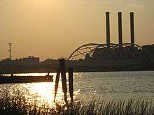 | |
|---|---|---|
| Major rivers | ||
| Cities & towns | ||
| Bridges | ||