Exeter, Rhode Island
| Exeter, Rhode Island | |
|---|---|
| Town | |
|
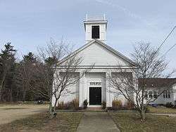
Chestnut Hill Baptist Church | |
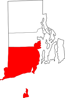
 Location of Exeter in Washington County, Rhode Island | |
| Coordinates: 41°34′N 71°36′W / 41.567°N 71.600°WCoordinates: 41°34′N 71°36′W / 41.567°N 71.600°W | |
| Country | United States |
| State | Rhode Island |
| County | Washington |
| Government | |
| • Town Moderator | Peter V. Lacouture |
| • Town Council |
Raymond A. Morrissey, Jr. Arlene B. Hicks Kevin P. McGovern Calvin A. Ellis Daniel W. Patterson |
| • Town Clerk | Lynn M. Hawkins |
| Area | |
| • Total | 58.4 sq mi (151.2 km2) |
| • Land | 57.7 sq mi (149.5 km2) |
| • Water | 0.7 sq mi (1.7 km2) |
| Elevation | 190 ft (58 m) |
| Population (2010) | |
| • Total | 6,425 |
| • Density | 111.4/sq mi (43.0/km2) |
| Time zone | Eastern (EST) (UTC-5) |
| • Summer (DST) | EDT (UTC-4) |
| ZIP code | 02822 (Exeter), 02874 (Saunderstown), 02892 (West Kingston) |
| Area code(s) | 401 |
| FIPS code | 44-25300[1] |
| GNIS feature ID | 1220087[2] |
Exeter is a town in Washington County, Rhode Island, United States. Exeter extends east from the Connecticut border to the town of North Kingstown. It is bordered to the north by West Greenwich and East Greenwich, and to the south by Hopkinton, Richmond, and South Kingstown. Exeter's postal code is 02822, although small parts of the town have the mailing address West Kingston (02892) or Saunderstown (02874). The population was 6,425 at the 2010 census.
Exeter was named for the Earl of Exeter.
History
The town of Exeter was formed in 1742 from the western part of North Kingstown. The name Exeter derives from the county town and cathedral city of Exeter in Devon, England.[3] Numerous other places have also been given the name Exeter. Exeter is noted by folklorists as the site of one of the best documented examples of vampire exhumation: the Mercy Brown Vampire Incident of 1892.
Geography
According to the United States Census Bureau, the town has a total area of 58.4 square miles (151 km2), of which, 57.7 square miles (149 km2) of it is land and 0.7 square miles (1.8 km2) of it (1.15%) is water.
Demographics
| Historical population | |||
|---|---|---|---|
| Census | Pop. | %± | |
| 1790 | 2,495 | — | |
| 1800 | 2,476 | −0.8% | |
| 1810 | 2,256 | −8.9% | |
| 1820 | 2,581 | 14.4% | |
| 1830 | 2,883 | 11.7% | |
| 1840 | 1,776 | −38.4% | |
| 1850 | 1,634 | −8.0% | |
| 1860 | 1,741 | 6.5% | |
| 1870 | 1,462 | −16.0% | |
| 1880 | 1,310 | −10.4% | |
| 1890 | 964 | −26.4% | |
| 1900 | 841 | −12.8% | |
| 1910 | 778 | −7.5% | |
| 1920 | 1,033 | 32.8% | |
| 1930 | 1,314 | 27.2% | |
| 1940 | 1,790 | 36.2% | |
| 1950 | 1,870 | 4.5% | |
| 1960 | 2,298 | 22.9% | |
| 1970 | 3,245 | 41.2% | |
| 1980 | 4,453 | 37.2% | |
| 1990 | 5,461 | 22.6% | |
| 2000 | 6,045 | 10.7% | |
| 2010 | 6,425 | 6.3% | |
| Est. 2015 | 6,587 | [4] | 2.5% |
As of the census[1] of 2000, there were 6,045 people, 2,085 households, and 1,592 families residing in the town. The population density was 104.7 people per square mile (40.4/km²). There were 2,196 housing units at an average density of 38.0 per square mile (14.7/km²). The racial makeup of the town was 96.36% White, 0.66% African American, 0.60% Native American, 0.74% Asian, 0.02% Pacific Islander, 0.33% from other races, and 1.29% from two or more races. Hispanic or Latino of any race were 1.27% of the population.
There were 2,085 households out of which 38.0% had children under the age of 18 living with them, 64.4% were married couples living together, 8.7% had a female householder with no husband present, and 23.6% were non-families. 16.8% of all households were made up of individuals and 4.6% had someone living alone who was 65 years of age or older. The average household size was 2.77 and the average family size was 3.15.
In the town the population was spread out with 26.3% under the age of 18, 6.4% from 18 to 24, 31.6% from 25 to 44, 26.0% from 45 to 64, and 9.7% who were 65 years of age or older. The median age was 38 years. For every 100 females there were 96.7 males. For every 100 females age 18 and over, there were 96.0 males.
The median income for a household in the town was $64,452, and the median income for a family was $74,157. Males had a median income of $47,083 versus $36,928 for females. The per capita income for the town was $25,530. About 4.5% of families and 5.5% of the population were below the poverty line, including 7.5% of those under age 18 and 10.2% of those age 65 or over.
Government
The town government is directed by a 5-member town council that is headed by a council president.[7] For the purpose of school administration, Exeter is a member town of the Exeter-West Greenwich Regional School District along with the neighboring town of West Greenwich.
Attractions and National Historic Places in Exeter
- Yawgoo Valley is the only ski resort in Rhode Island.
- Austin Farm Road Agricultural Area
- Baptist Church in Exeter
- Exeter Chapel
- Fisherville Historic and Archeological District
- Hallville Historic and Archeological District
- Lawton's Mill
- Simon Lillibridge Farm
- Parris Brook Historic and Archeological District
- Queen's Fort
- Sodom Mill Historic and Archeological District
- Tomaquag Museum, only solely Native American museum in Rhode Island
Adjacent Towns
 |
West Greenwich | East Greenwich | | |
| Voluntown, Connecticut | |
North Kingstown | ||
| ||||
| | ||||
| Hopkinton, Richmond, South Kingstown |
References
- 1 2 "American FactFinder". United States Census Bureau. Retrieved 2008-01-31.
- ↑ "US Board on Geographic Names". United States Geological Survey. 2007-10-25. Retrieved 2008-01-31.
- ↑ Gannett, Henry (1905). The Origin of Certain Place Names in the United States. Govt. Print. Off. p. 122.
- ↑ "Annual Estimates of the Resident Population for Incorporated Places: April 1, 2010 to July 1, 2015". Retrieved July 2, 2016.
- ↑ "Census of Population and Housing". Census.gov. Retrieved June 4, 2016.
- ↑ Snow, Edwin M. (1867). Report upon the Census of Rhode Island 1865. Providence, RI: Providence Press Company.
- ↑ Town of Exeter profile, Rhode Island Economic Development Corporation
External links
| Wikimedia Commons has media related to Exeter, Rhode Island. |
| Wikivoyage has a travel guide for Exeter, Rhode Island. |
- EDC Profile of Exeter
- RI.GOV - Town of Exeter
- Town of Exeter, Rhode Island website
- Exeter Town Library
- Exeter-West Greenwich Regional School District
- Exeter Town Hall
- Welcome to South County Rhode Island
- R.I. Veterans Memorial Cemetery
Providence (capital) | |
| Topics |
|
| Society |
|
| Regions | |
| Cities | |
| Towns |
|