Guemes Island
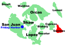
Guemes Island is a small island in western Skagit County, Washington, United States. It is located north of Fidalgo Island and the town of Anacortes, and is accessible by both private boat and by the Guemes Island ferry operated by Skagit County.
Guemes Island was named after the Viceroy of New Spain, Juan Vicente de Güemes, who commissioned an expedition that revealed the islands to Spain in 1794.[1]
Island life
Guemes Island has a rural character with limited facilities.
Two of the island’s beaches are private but most beach access is public, including multiple boat launches. There are also two parks: one in the middle of the island known as Schoolhouse Park, and the other, Young's Park,[2] located on North Beach near The Guemes Island Resort.
The community located on Guemes Island is generally referred to as "Guemes".
History
Guemes Island was a traditional location for the Samish tribe's winter villages. Around 1873, the Samish, displaced due to government decisions, established a new village on Guemes, near Potlatch Beach. Because they occupied the only natural spring on the island, the Samish were forced off the island by their neighbors in 1912.[3]
Guemes Island was named by the Spanish explorer José María Narváez as Isla de Güemes, during the 1791 expedition of Francisco de Eliza, in honor of the Viceroy of Mexico, Juan Vicente de Güemes Padilla Horcasitas y Aguayo, 2nd Count of Revillagigedo.[4][5]
In 1841 Charles Wilkes of the United States Exploring Expedition gave the name "Lawrence Island" to Guemes Island, to honor the American naval officer James Lawrence. He also gave the name "Hornet Harbor" to Guemes Channel, for the USS Hornet, which Lawrence commanded during the War of 1812. To the waterway north of the island, part of Bellingham Bay, Wilkes gave the name "Penguin Harbor", for the British vessel Penguin, captured by Lawrence. These names disappeared after 1847, when the British Captain Henry Kellett reorganized the British Admiralty charts, in the process removing the "pro-American" names given by Wilkes and affirming pro-British names and Spanish names.[6]
Guemes Island was also commonly known locally as Dog Island in the early 20th century, from the large number of Salish Wool Dogs living wild on the island.[7]
Politics
In the 2008 U.S. presidential election, Democrat Barack Obama received 53.9% of the vote, Republican John McCain 44.1%, and others 2% in Skagit County. In the 2004 U.S. Presidential election, Republican George W. Bush received 50% of the vote, Democrat John Kerry 48.1%, and others 1.8%.
Demographics
The following Census statistics represent a block group that also contains the neighboring islands of Cypress Island, Sinclair Island, and Vendovi Island. As of the census[8] of 2000, there are 605 people, 292 households, and 180 families residing in the block group. There are 626 housing units. The racial makeup of the block group is 95.70% White, 1.16% African American, 0.83% Native American, 0.00% Asian, 0.00% Pacific Islander, 0.99% from other races, and 1.32% from two or more races. 1.32% of the population are Hispanic or Latino of any race.
There are 292 households out of which 22.9% have children under the age of 18 living with them, 57.2% are married couples living together, 3.4% have a female householder with no husband present, and 29.0% are non-families. 30.8% of all households are made up of individuals and 39.4% have someone living alone who is 65 years of age or older. The average household size is 1.95 and the average family size is 2.38.
In the block group the population is spread out with 16.0% under the age of 18, 2.6% from 18 to 24, 11.6% from 25 to 44, 41.3% from 45 to 64, and 27.9% who are 65 years of age or older. The median age is 53 years. For every 100 females there are 119.2 males. For every 100 females age 18 and over, there are 104.8 males.
The median income for a household in the block group is $40,039, and the median income for a family is unavailable. Income by sex is also unavailable, as is per capita income. 8.1% of the population is below the poverty line. Family poverty statistics are unavailable. Out of the total population, 36.1% of those under the age of 18 and 0.0% of those 65 and older are living below the poverty line.
Magnetic disturbance
Nautical and aeronautical charts note a magnetic disturbance off the southeastern tip of Guemes Island. The disturbance affects compasses enough to cause as much as 14° discrepancy from average local variation.[9]
References
- ↑ GuemasIslandLife.org
- ↑ http://www.skagitcounty.net/Common/asp/default.asp?d=ParksAndRecreation&c=General&p=parks/youngs.htm and http://www.skagitcounty.net/Common/Asp/Default.asp?d=ParksAndRecreation&c=General&p=parks/index.htm
- ↑ Ruby, Robert H.; Brown, John A.; Collins, Cary (2013). A Guide to the Indian Tribes of the Pacific Northwest. University of Oklahoma Press. p. 257.
- ↑ Phillips, James W. (1971). Washington State Place Names. University of Washington Press. ISBN 0-295-95158-3.
- ↑ McDowell, Jim (1998). José Narváez: The Forgotten Explorer. Spokane, Washington: The Arthur H. Clark Company. p. 55. ISBN 0-87062-265-X.
- ↑ Meany, Edmond S. (1919). "Origin of Washington Geographic Names". The Pacific Northwest Quarterly. Washington University State Historical Society. X: 56. Retrieved 2009-06-11.
- ↑ http://www.kplu.org/post/dog-fur-knitting-new-craft-old-northwest-tradition
- ↑ "American FactFinder". United States Census Bureau. Retrieved 2008-01-31.
- ↑ http://www.nauticalcharts.noaa.gov/nsd/xml2html.php?xml=coastpilot/files/cp7/12.xml
External links
- Map: 48°32′40″N 122°36′59″W / 48.54444°N 122.61639°WCoordinates: 48°32′40″N 122°36′59″W / 48.54444°N 122.61639°W
Municipalities and communities of Skagit County, Washington, United States | ||
|---|---|---|
| Cities | 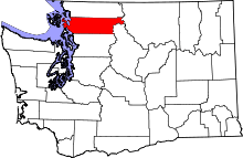 | |
| Towns | ||
| CDPs | ||
| Unincorporated communities | ||
| Indian reservation | ||
| Ghost towns | ||