| [4] |
Name on the Register[5] |
Image |
Date listed[6] |
Location |
City or town |
Description |
|---|
| 1 |
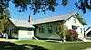
F. F. Beale House |
Upload image |
000000001993-05-14-0000May 14, 1993
(#93000386) |
1802 Cleveland Boulevard
43°39′25″N 116°40′46″W / 43.656821°N 116.679326°W / 43.656821; -116.679326 (F. F. Beale House) |
Caldwell |
|
| 2 |
Blatchley Hall |
Upload image |
000000001978-03-08-0000March 8, 1978
(#78001055) |
College of Idaho campus
43°39′09″N 116°40′31″W / 43.652404°N 116.675328°W / 43.652404; -116.675328 (Blatchley Hall) |
Caldwell |
|
| 3 |
Boise River and Canal Bridge |
Upload image |
000000002007-02-07-0000February 7, 2007
(#07000003) |
Plymouth St.
43°41′20″N 116°41′13″W / 43.688899°N 116.686844°W / 43.688899; -116.686844 (Boise River and Canal Bridge) |
Caldwell |
|
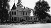
| 4 |
Caldwell Carnegie Library |
Upload image |
000000001979-06-18-0000June 18, 1979
(#79000784) |
1101 Cleveland Boulevard
43°39′44″N 116°41′10″W / 43.662172°N 116.686124°W / 43.662172; -116.686124 (Caldwell Carnegie Library) |
Caldwell |
|
| 5 |
Caldwell Historic District |
Upload image |
000000001982-07-19-0000July 19, 1982
(#82002509) |
Roughly bounded by Railroad and Arthur Sts. and 7th and 9th Aves.
43°39′59″N 116°41′16″W / 43.666390°N 116.687872°W / 43.666390; -116.687872 (Caldwell Historic District) |
Caldwell |
|
| 6 |
Caldwell Odd Fellow Home for the Aged |
Upload image |
000000001982-11-17-0000November 17, 1982
(#82000322) |
N. 14th Ave.
43°39′59″N 116°40′24″W / 43.666408°N 116.673251°W / 43.666408; -116.673251 (Caldwell Odd Fellow Home for the Aged) |
Caldwell |
|
| 7 |
Caldwell Residential Historic District |
Upload image |
000000002002-09-23-0000September 23, 2002
(#02001064) |
Roughly bounded by Cleveland Boulevard, Everett St., S. 12th Ave., and S. 20th Ave.
43°39′28″N 116°40′56″W / 43.657885°N 116.682305°W / 43.657885; -116.682305 (Caldwell Residential Historic District) |
Caldwell |
|
| 8 |
E. H. Dewey Stores |
|
000000001982-11-17-0000November 17, 1982
(#82000323) |
1013-1015 1st St., S.
43°34′47″N 116°33′41″W / 43.579646°N 116.561474°W / 43.579646; -116.561474 (E. H. Dewey Stores) |
Nampa |
|
| 9 |
Diversion Dam and Deer Flat Embankments |
|
000000001976-03-15-0000March 15, 1976
(#76000666) |
Southeast of Boise on the Boise River
43°34′26″N 116°42′23″W / 43.573889°N 116.706389°W / 43.573889; -116.706389 (Diversion Dam and Deer Flat Embankments) |
Boise vicinity |
Extends into Ada County
|
| 10 |
Henry W. and Ida Frost Dorman House |
Upload image |
000000002000-07-05-0000July 5, 2000
(#00000756) |
114 E. Logan St.
43°39′17″N 116°41′50″W / 43.654812°N 116.697274°W / 43.654812; -116.697274 (Henry W. and Ida Frost Dorman House) |
Caldwell |
|
| 11 |
Farmers and Merchants Bank |
|
000000001976-05-13-0000May 13, 1976
(#76000670) |
101 11th Ave., S.
43°34′46″N 116°33′40″W / 43.579534°N 116.561245°W / 43.579534; -116.561245 (Farmers and Merchants Bank) |
Nampa |
|
| 12 |
Fort Boise and Riverside Ferry Sites |
|
000000001974-12-24-0000December 24, 1974
(#74000736) |
Northwest of Parma on the Snake River
43°49′25″N 117°01′13″W / 43.823644°N 117.020383°W / 43.823644; -117.020383 (Fort Boise and Riverside Ferry Sites) |
Parma vicinity |
|
| 13 |
Guffey Butte – Black Butte Archeological District |
|
000000001978-10-10-0000October 10, 1978
(#78001038) |
Along approximately 34 miles (55 km) of the Snake River in Canyon, Ada, Owyhee, and Elmore counties[7]
43°17′57″N 116°31′18″W / 43.299253°N 116.521777°W / 43.299253; -116.521777 (Guffey Butte – Black Butte Archeological District) |
Grand View |
|
| 14 |
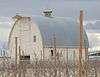
Horse Barn |
Upload image |
000000001978-10-11-0000October 11, 1978
(#78001057) |
Northeast of Nampa at Idaho State School and Hospital
43°36′12″N 116°31′32″W / 43.603228°N 116.525637°W / 43.603228; -116.525637 (Horse Barn) |
Nampa |
|
| 15 |
Ellen Houlder Farm |
Upload image |
000000001994-06-23-0000June 23, 1994
(#94000631) |
Arena Valley Rd. (Route 2) west of Wilder
43°40′49″N 116°59′28″W / 43.680394°N 116.991113°W / 43.680394; -116.991113 (Ellen Houlder Farm) |
Wilder |
|
| 16 |
Idaho State Sanitarium Administration Building |
Upload image |
000000001982-11-17-0000November 17, 1982
(#82000324) |
Northeast of Nampa on 11th Ave., N.
43°36′09″N 116°31′53″W / 43.602455°N 116.531301°W / 43.602455; -116.531301 (Idaho State Sanitarium Administration Building) |
Nampa |
|
| 17 |
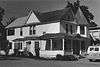
Thomas K. Little House |
Upload image |
000000001980-08-18-0000August 18, 1980
(#80001295) |
703 E. Belmont St.
43°40′08″N 116°41′08″W / 43.668829°N 116.685467°W / 43.668829; -116.685467 (Thomas K. Little House) |
Caldwell |
|
| 18 |
Jacob P. Lockman House |
Upload image |
000000002005-07-27-0000July 27, 2005
(#05000735) |
23 9th Ave. N
43°34′58″N 116°33′40″W / 43.582903°N 116.561160°W / 43.582903; -116.561160 (Jacob P. Lockman House) |
Nampa |
|
| 19 |
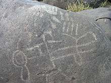
Map Rock Petroglyphs Historic District |
Upload image |
000000001982-11-15-0000November 15, 1982
(#82000325) |
Map Rock Rd.[8]
43°25′16″N 116°42′17″W / 43.421078°N 116.704667°W / 43.421078; -116.704667 (Map Rock Petroglyphs Historic District) |
Givens Hot Springs |
|
| 20 |
Mercy Hospital |
Upload image |
000000002014-08-19-0000August 19, 2014
(#14000504) |
1615 8th St., S.
43°34′12″N 116°33′45″W / 43.569987°N 116.562380°W / 43.569987; -116.562380 (Mercy Hospital) |
Nampa |
Demolished in 2016[9]
|
| 21 |
Middleton Substation |
Upload image |
000000001973-05-07-0000May 7, 1973
(#73000683) |
State Highway 44
43°42′23″N 116°37′07″W / 43.706344°N 116.618536°W / 43.706344; -116.618536 (Middleton Substation) |
Middleton |
|
| 22 |
Nampa American Legion Chateau |
|
000000001982-11-17-0000November 17, 1982
(#82000326) |
1508 2nd St., S.
43°34′33″N 116°33′26″W / 43.575885°N 116.557086°W / 43.575885; -116.557086 (Nampa American Legion Chateau) |
Nampa |
|
| 23 |
Nampa and Meridian Irrigation District Office |
|
000000001982-11-17-0000November 17, 1982
(#82000329) |
1503 1st St., S.
43°34′35″N 116°33′24″W / 43.576413°N 116.556612°W / 43.576413; -116.556612 (Nampa and Meridian Irrigation District Office) |
Nampa |
|
| 24 |
Nampa City Hall |
|
000000001985-05-09-0000May 9, 1985
(#85000967) |
203 12th Ave., S.
43°34′41″N 116°33′41″W / 43.578051°N 116.561293°W / 43.578051; -116.561293 (Nampa City Hall) |
Nampa |
Demolished in 1991
|
| 25 |
Nampa Department Store |
Upload image |
000000001982-11-17-0000November 17, 1982
(#82000327) |
1st St., S. and 13th Ave.
43°34′40″N 116°33′31″W / 43.577765°N 116.558715°W / 43.577765; -116.558715 (Nampa Department Store) |
Nampa |
|
| 26 |
Nampa Depot |
|
000000001972-11-03-0000November 3, 1972
(#72000438) |
12th Ave. and Front St.
43°34′47″N 116°33′31″W / 43.579609°N 116.558675°W / 43.579609; -116.558675 (Nampa Depot) |
Nampa |
|
| 27 |
Nampa First Methodist Episcopal Church |
Upload image |
000000001982-11-17-0000November 17, 1982
(#82000328) |
12th Ave., S. and 4th St.
43°34′34″N 116°33′46″W / 43.576210°N 116.562746°W / 43.576210; -116.562746 (Nampa First Methodist Episcopal Church) |
Nampa |
|
| 28 |
Nampa Historic District |
|
000000001983-08-18-0000August 18, 1983
(#83000284) |
1200 and 1300 blocks S. 1st St.
43°34′41″N 116°33′31″W / 43.578034°N 116.558694°W / 43.578034; -116.558694 (Nampa Historic District) |
Nampa |
|
| 29 |
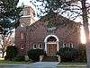
Nampa Presbyterian Church |
|
000000001982-11-17-0000November 17, 1982
(#82000330) |
2nd St. and 15th Ave., S.
43°34′33″N 116°33′29″W / 43.575889°N 116.558007°W / 43.575889; -116.558007 (Nampa Presbyterian Church) |
Nampa |
|
| 30 |
Nampa Valley Grange No.131 |
|
000000002013-02-13-0000February 13, 2013
(#13000002) |
203 5th Ave., S.
43°34′59″N 116°34′07″W / 43.583062°N 116.568552°W / 43.583062; -116.568552 (Nampa Valley Grange No.131) |
Nampa |
|
| 31 |
North Caldwell Historic District |
Upload image |
000000001979-09-05-0000September 5, 1979
(#79000785) |
9th, Albany, and Belmont Sts.
43°40′01″N 116°41′03″W / 43.667064°N 116.684258°W / 43.667064; -116.684258 (North Caldwell Historic District) |
Caldwell |
|
| 32 |
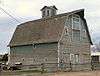
George Obendorf Gothic Arch Truss Barn |
|
000000001999-10-28-0000October 28, 1999
(#99001278) |
24047 Batt Corner Rd.
43°43′14″N 116°55′23″W / 43.720474°N 116.922969°W / 43.720474; -116.922969 (George Obendorf Gothic Arch Truss Barn) |
Wilder vicinity |
|
| 33 |
Old Nampa Neighborhood Historic District |
Upload image |
000000002007-03-21-0000March 21, 2007
(#07000164) |
Roughly bounded by 4th Ave., S, 4th St., S, 11th Ave., S, and 9th St., S.
43°34′41″N 116°34′10″W / 43.578120°N 116.569400°W / 43.578120; -116.569400 (Old Nampa Neighborhood Historic District) |
Nampa |
|
| 34 |
Peckham Barn |
|
000000001982-10-07-0000October 7, 1982
(#82000389) |
North of Wilder on U.S. Route 95
43°41′01″N 116°54′37″W / 43.683597°N 116.910336°W / 43.683597; -116.910336 (Peckham Barn) |
Wilder vicinity |
|
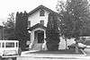
| 35 |
John C. Rice House |
|
000000001980-05-27-0000May 27, 1980
(#80001296) |
1520 Cleveland Boulevard
43°39′31″N 116°40′55″W / 43.658583°N 116.681878°W / 43.658583; -116.681878 (John C. Rice House) |
Caldwell |
Building apparently no longer exists.
|
| 36 |
Roswell Grade School |
|
000000001982-11-17-0000November 17, 1982
(#82000331) |
State Highway 18 and Stephan Lane
43°44′55″N 116°57′41″W / 43.748696°N 116.961497°W / 43.748696; -116.961497 (Roswell Grade School) |
Roswell |
|
| 37 |
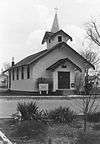
Sacred Hearts of Jesus and Mary Church |
|
000000001982-11-17-0000November 17, 1982
(#82000334) |
608 7th St.
43°47′15″N 116°56′17″W / 43.787473°N 116.938141°W / 43.787473; -116.938141 (Sacred Hearts of Jesus and Mary Church) |
Parma |
Building no longer exists.
|
| 38 |
St. Mary's Catholic Church |
|
000000001982-11-17-0000November 17, 1982
(#82000332) |
616 Dearborn St.
43°39′51″N 116°41′32″W / 43.664276°N 116.692252°W / 43.664276; -116.692252 (St. Mary's Catholic Church) |
Caldwell |
|
| 39 |
St. Paul's Rectory and Sisters' House |
|
000000001982-11-17-0000November 17, 1982
(#82000333) |
810 15th Ave., S.
43°34′15″N 116°33′49″W / 43.570822°N 116.563663°W / 43.570822; -116.563663 (St. Paul's Rectory and Sisters' House) |
Nampa |
Building no longer exists.
|
| 40 |
Sterry Hall |
Upload image |
000000001978-03-08-0000March 8, 1978
(#78001056) |
College of Idaho campus
43°39′14″N 116°40′36″W / 43.653816°N 116.676745°W / 43.653816; -116.676745 (Sterry Hall) |
Caldwell |
|
| 41 |
A. K. Steunenberg House |
Upload image |
000000001982-11-17-0000November 17, 1982
(#82000335) |
409 N. Kimball Ave.
43°40′09″N 116°41′02″W / 43.669193°N 116.683897°W / 43.669193; -116.683897 (A. K. Steunenberg House) |
Caldwell |
|
| 42 |
A. H. Stewart House |
|
000000001979-10-25-0000October 25, 1979
(#79000786) |
3rd St. and Bates Ave
43°47′10″N 116°56′37″W / 43.786237°N 116.943682°W / 43.786237; -116.943682 (A. H. Stewart House) |
Parma |
Building no longer exists.
|
| 43 |
Carrie Adell Strahorn Memorial Library |
Upload image |
000000001982-04-15-0000April 15, 1982
(#82002510) |
College of Idaho campus
43°39′10″N 116°40′36″W / 43.652800°N 116.676786°W / 43.652800; -116.676786 (Carrie Adell Strahorn Memorial Library) |
Caldwell |
|
| 44 |
U.S. Post Office – Caldwell Main |
Upload image |
000000001989-03-16-0000March 16, 1989
(#89000131) |
823 Arthur St.
43°39′55″N 116°41′14″W / 43.665299°N 116.687109°W / 43.665299; -116.687109 (U.S. Post Office – Caldwell Main) |
Caldwell |
|
| 45 |
U.S. Post Office – Nampa Main |
|
000000001989-03-16-0000March 16, 1989
(#89000132) |
123 11th Ave., S.
43°34′45″N 116°33′42″W / 43.579160°N 116.561767°W / 43.579160; -116.561767 (U.S. Post Office – Nampa Main) |
Nampa |
|
| 46 |
Orton H. Wiley House |
Upload image |
000000001986-09-11-0000September 11, 1986
(#86002163) |
524 E. Dewey Ave.
43°33′49″N 116°33′58″W / 43.563665°N 116.566071°W / 43.563665; -116.566071 (Orton H. Wiley House) |
Nampa |
|
.jpg)
.jpg)
.jpg)
.jpg)
.jpg)
.jpg)
.jpg)