Caldwell, Idaho
| Caldwell, Idaho | |
|---|---|
| City | |
| Nickname(s): The Treasure of the Valley | |
| Motto: More to Offer | |
 Location in Canyon County and the state of Idaho | |
 Caldwell, Idaho Location in the United States | |
| Coordinates: 43°39′30″N 116°40′49″W / 43.65833°N 116.68028°WCoordinates: 43°39′30″N 116°40′49″W / 43.65833°N 116.68028°W | |
| Country | United States |
| State | Idaho |
| County | Canyon |
| Government | |
| • Mayor | Garret Nancolas |
| Area[1] | |
| • City | 22.11 sq mi (57.26 km2) |
| • Land | 22.06 sq mi (57.14 km2) |
| • Water | 0.05 sq mi (0.13 km2) |
| Elevation | 2,375 ft (724 m) |
| Population (2010)[2] | |
| • City | 46,237 |
| • Estimate (2013[3]) | 48,957 |
| • Density | 2,096.0/sq mi (809.3/km2) |
| • Metro | 624,000 |
| Time zone | Mountain (UTC-7) |
| • Summer (DST) | Mountain (UTC-6) |
| ZIP codes | 83605-83607 |
| Area code(s) | 208 |
| FIPS code | 16-12250 |
| GNIS feature ID | 0397514 |
| Website | www.cityofcaldwell.com |
Caldwell is a city in and the county seat of Canyon County, Idaho, United States.[4] The population was 46,237 at the 2010 census.[5]
Caldwell is considered part of the Boise metropolitan area. Caldwell is the home of the College of Idaho and College of Western Idaho.[6]
History

The present day location of the City of Caldwell is along a natural passageway to the Inland and Pacific Northwest. Indian tribes from the west coast, north Idaho and as far away as Colorado would come to the banks of the Boise River for annual trading fairs, or rendezvous. European and some Hawaiian explorers and traders soon followed the paths left by Indians and hopeful emigrants later forged the Oregon Trail and followed the now hardened paths to seek a better life in the Oregon Territory. Pioneers of the Trail traveled along the Boise River to Canyon Hill and forded the river close to the "Silver Bridge" on Plymouth Street.
During the Civil War, the discovery of gold in Idaho's mountains brought a variety of new settlers into the area. Many never made it to the mines but chose to settle along the Boise River and run ferries, stage stations, and freighting businesses. These early entrepreneurs created small ranches and farms in the river valleys. Caldwell's inception occurred largely as a result of the construction of the Oregon Short Line Railroad, which connected Wyoming to Oregon through Idaho. Robert E. Strahorn came to the Boise River Valley in 1883 to select a route for the railroad. He rejected the grade into Boise City as too steep and chose a site thirty miles to the west. He drove a stake into an alkali flat of sagebrush and greasewood and the City of Caldwell was platted. Caldwell was named after one of Strahorn's business partners, Alexander Caldwell, a former Senator from the State of Kansas.
When Caldwell was platted in August 1883, its founder, the Idaho and Oregon Land Improvement Company, started persuading settlers and businessmen to move to the area. Within four months, Caldwell had 600 residents living in 150 dwellings, 40 businesses in operation, a school, a telephone exchange and two newspapers. On January 15, 1890 the Board of Commissioners of Ada County issued a handwritten order incorporating the City of Caldwell. The College of Idaho was founded in Caldwell in 1891 and still is in existence today. In 1892, Canyon County was established from a portion of Ada County. Caldwell was named the county seat. Irrigation canals and waterways were constructed throughout Canyon County. These facilities provided the foundation for an agricultural based economy in Caldwell. The Oregon Short Line Railroad became part of the larger Union Pacific Railroad network and in 1906 the Caldwell freight and passenger depot was constructed. Caldwell experienced moderate growth as an agricultural processing, commercial retail and educational center during the twentieth century.[7]
In March 1908, at the end of a series of trials relating to a Coeur d'Alene miners' uprising and the Colorado Labor Wars, Albert Horsley, better known by his pseudonym Harry Orchard, pleaded guilty in District Court in Caldwell to the assassination of former Idaho governor Frank Steunenberg. Judge Fremont Wood sentenced Orchard to hang, but his sentence was commuted, and he lived out the rest of his life in an Idaho prison. This result flowed from Orchard's having turned state's evidence and having become the prosecution's star witness against Big Bill Haywood and two other leaders of the Western Federation of Miners whom the prosecution alleged had masterminded Steunenberg's assassination. Haywood and his colleagues, however, represented by Clarence Darrow, were acquitted.
Features
Caldwell has 5 secondary schools including Caldwell High School and 6 elementary schools.[8] Caldwell also has 10 city parks, a public golf course near downtown, a city pool,[9] and a skatepark.[10]
In addition, the Caldwell Industrial Airport is located southeast of downtown. The College of Idaho is located in Caldwell and is one of the oldest 4 year institutions in the state
Caldwell has a high quality water system, which remained untreated and met all federal guidelines until the 1990s when the Federal Government mandated chlorination.
Geography
Caldwell is located at 43°39′30″N 116°40′49″W / 43.65833°N 116.68028°W (43.658239, -116.680390).[11]
According to the United States Census Bureau, the city has a total area of 22.11 square miles (57.26 km2), of which, 22.06 square miles (57.14 km2) is land and 0.05 square miles (0.13 km2) is water.[1]
Climate
Caldwell experiences a semi-arid climate (Köppen BSk) with short, cold winters and hot, dry summers.
| Climate data for Caldwell, Idaho | |||||||||||||
|---|---|---|---|---|---|---|---|---|---|---|---|---|---|
| Month | Jan | Feb | Mar | Apr | May | Jun | Jul | Aug | Sep | Oct | Nov | Dec | Year |
| Record high °F (°C) | 66 (19) |
70 (21) |
84 (29) |
94 (34) |
102 (39) |
106 (41) |
110 (43) |
112 (44) |
104 (40) |
94 (34) |
79 (26) |
69 (21) |
112 (44) |
| Average high °F (°C) | 37.1 (2.8) |
46.1 (7.8) |
57.4 (14.1) |
66.3 (19.1) |
75.1 (23.9) |
84.2 (29) |
92.6 (33.7) |
91.7 (33.2) |
80.8 (27.1) |
67.0 (19.4) |
49.3 (9.6) |
37.9 (3.3) |
65.5 (18.6) |
| Average low °F (°C) | 21.1 (−6.1) |
26.2 (−3.2) |
32.6 (0.3) |
38.5 (3.6) |
46.2 (7.9) |
52.8 (11.6) |
58.1 (14.5) |
55.8 (13.2) |
45.8 (7.7) |
36.6 (2.6) |
28.4 (−2) |
21.3 (−5.9) |
38.6 (3.7) |
| Record low °F (°C) | −31 (−35) |
−21 (−29) |
−6 (−21) |
12 (−11) |
22 (−6) |
29 (−2) |
37 (3) |
31 (−1) |
23 (−5) |
15 (−9) |
−4 (−20) |
−34 (−37) |
−34 (−37) |
| Average precipitation inches (mm) | 1.55 (39.4) |
1.11 (28.2) |
1.29 (32.8) |
1.13 (28.7) |
1.01 (25.7) |
0.67 (17) |
0.30 (7.6) |
0.35 (8.9) |
0.59 (15) |
0.73 (18.5) |
1.28 (32.5) |
1.39 (35.3) |
11.4 (289.6) |
| Source #1: NOAA (normals, 1971–2000)[12] | |||||||||||||
| Source #2: The Weather Channel (Records)[13] | |||||||||||||
Demographics

| Historical population | |||
|---|---|---|---|
| Census | Pop. | %± | |
| 1890 | 779 | — | |
| 1900 | 997 | 28.0% | |
| 1910 | 3,543 | 255.4% | |
| 1920 | 5,106 | 44.1% | |
| 1930 | 4,974 | −2.6% | |
| 1940 | 7,272 | 46.2% | |
| 1950 | 10,487 | 44.2% | |
| 1960 | 12,230 | 16.6% | |
| 1970 | 14,219 | 16.3% | |
| 1980 | 17,699 | 24.5% | |
| 1990 | 18,400 | 4.0% | |
| 2000 | 25,967 | 41.1% | |
| 2010 | 46,237 | 78.1% | |
| Est. 2015 | 51,686 | [14] | 11.8% |
2010 census
As of the census[2] of 2010, there were 46,237 people, 14,895 households, and 10,776 families residing in the city. The population density was 2,096.0 inhabitants per square mile (809.3/km2). There were 16,323 housing units at an average density of 739.9 per square mile (285.7/km2). The racial makeup of the city was 77.5% White, 0.6% African American, 1.2% Native American, 0.9% Asian, 0.1% Pacific Islander, 16.1% from other races, and 3.6% from two or more races. Hispanic or Latino of any race were 35.4% of the population.
There were 14,895 households of which 46.5% had children under the age of 18 living with them, 50.5% were married couples living together, 15.5% had a female householder with no husband present, 6.4% had a male householder with no wife present, and 27.7% were non-families. 21.7% of all households were made up of individuals and 8.5% had someone living alone who was 65 years of age or older. The average household size was 3.00 and the average family size was 3.51.
The median age in the city was 28.2 years. 33.1% of residents were under the age of 18; 11.5% were between the ages of 18 and 24; 28.4% were from 25 to 44; 18.2% were from 45 to 64; and 8.9% were 65 years of age or older. The gender makeup of the city was 49.4% male and 50.6% female.
The median income for a household in the city was $37,336. The per capita income for the city was $15,731. About 20.2% of the population was below the poverty line.[5]
Revitalization
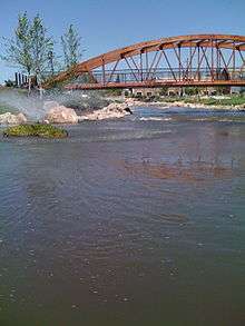
In 2009 the City of Caldwell completed a revitalization project to restore Indian Creek. Indian Creek runs through downtown Caldwell. However, because it was primarily used for sewage from local industries it had been covered over. The restored creek includes attractions such as suspended bridges.[16] Caldwell currently holds an annual Indian Creek Festival every September that was first held in 2003. The event includes a fun run and a tug of war.[17]
Notable people
- Joseph Albertson − founder of Albertson's grocery store chain
- Troy Beyer - actress, attended high school in Caldwell
- Ronee Blakley - actress and singer
- George Blankley - former BSU head basketball coach, went to Caldwell High and the College of Idaho
- Daniel Carter - LDS composer
- Thomas C. Coffin - Congressman
- Dame Darcy - cartoonist and performer
- Shirley Englehorn - LPGA golfer
- A. J. Feeley - NFL quarterback
- Mike Garman - Major League Baseball pitcher
- Lawrence H. Gipson - Pulitzer Prize winner, moved to Caldwell as a boy and later taught at the College of Idaho
- Ron Hadley - NFL linebacker
- Maria Dahvana Headley - writer, attended Vallivue High School
- Wayne Hooper - gospel music composer and singer, graduated from Gem State Academy
- Gary Hubler - champion of the Formula 1 class of the Reno Air Races
- David Kamo - motorcycle racer
- James Knight - former University of Washington football coach, lived in Caldwell in his later years
- Mark Lindsay − musician, now in Grangeville
- Edward Lodge - United States District Court Judge
- Larry Lujack - disc jockey
- Dean McAdams - NFL player
- Ray McDonald - NFL running back, graduated from Caldwell High School
- Jim McMillan - gridiron football player
- John T. Morrison - original faculty member of the College of Idaho, former Idaho governor
- Cody Pickett - NFL quarterback
- Jay Pickett − actor
- Frank Reberger - Major League Baseball player and coach
- Paul Revere (and the Raiders) − musician
- Frank Steunenberg - assassinated Governor of Idaho
- Gary Stevens - jockey, won Kentucky Derby three times
- Steve Symms - former U.S. Senator and Congressman
- Renee Tenison - Playboy Playmate of the Year 1990
- Rosie Tenison - actress and model
- Randy Trautman - Canadian football defensive lineman
- Gys van Beek - a Dutch American inventor who as a member of the Dutch resistance during World War II helped rescue members of the Allied forces and is also recognized as an Aid Giver for helping Jews escaping the Holocaust[18]
References
- 1 2 "US Gazetteer files 2010". United States Census Bureau. Archived from the original on 2012-07-14. Retrieved 2012-12-18.
- 1 2 "American FactFinder". United States Census Bureau. Retrieved 2012-12-18.
- ↑ "Population Estimates". United States Census Bureau. Archived from the original on 2014-12-10. Retrieved 2014-12-16.
- ↑ "Find a County". National Association of Counties. Archived from the original on 2011-05-31. Retrieved 2011-06-07.
- 1 2 "Caldwell Quick Facts". U.S. Census Bureau. Retrieved 2012-02-26.
- ↑ "College of Western Idaho". College of Western Idaho. Retrieved 2016-01-10.
- ↑ http://city.cityofcaldwell.com/file_depot/0-10000000/10000-20000/13986/folder/59467/Comprehensive+Plan+-+adopted+May+2010.pdf
- ↑ "Caldwell School District". Retrieved 2012-02-26.
- ↑ "City of Caldwell". Retrieved 2012-02-26.
- ↑ "Caldwell, Idaho skatepark". northwestskatepark.com. Retrieved 2012-02-26.
- ↑ "US Gazetteer files: 2010, 2000, and 1990". United States Census Bureau. 2011-02-12. Retrieved 2011-04-23.
- ↑ "Climatography of the United States NO.81" (PDF). National Oceanic and Atmospheric Administration. Retrieved January 16, 2011.
- ↑ "Monthly Averages for Caldwell, ID". The Weather Channel. Retrieved January 16, 2011.
- ↑ "Annual Estimates of the Resident Population for Incorporated Places: April 1, 2010 to July 1, 2015". Retrieved July 2, 2016.
- ↑ "Census of Population and Housing". Census.gov. Archived from the original on May 11, 2015. Retrieved June 4, 2015.
- ↑ "Indian Creek Restoration". Cooperative Conservation America. Retrieved 2012-02-26.
- ↑ Lea, Dan (2010-09-16). "Go with the flow at Indian Creek Festival". Idaho Press Tribune. Retrieved 2012-02-26.
- ↑ Gys van Beek
External links
- Official website
- Caldwell Chamber of Commerce
- Idaho Press-Tribune — Western Treasure Valley's (Caldwell and Nampa) newspaper
- Caldwell Police Department
Municipalities and communities of Canyon County, Idaho, United States | ||
|---|---|---|
| Cities | ||
| Unincorporated communities | ||