National Register of Historic Places listings in Bannock County, Idaho
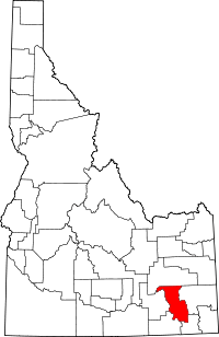
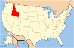
Location of Bannock County in Idaho
This is a list of the National Register of Historic Places listings in Bannock County, Idaho.
This is intended to be a complete list of the properties and districts on the National Register of Historic Places in Bannock County, Idaho, United States. Latitude and longitude coordinates are provided for many National Register properties and districts; these locations may be seen together in a map.[1]
There are 29 properties and districts listed on the National Register in the county, including 1 National Historic Landmark. More may be added; properties and districts nationwide are added to the Register weekly.[2]
- This National Park Service list is complete through NPS recent listings posted December 16, 2016.[3]
Current listings
| [4] | Name on the Register[5] | Image | Date listed[6] | Location | City or town | Description |
|---|---|---|---|---|---|---|
| 1 | A.F.R. Building |  |
(#90001737) |
501 N. Main St. 42°51′55″N 112°27′13″W / 42.865278°N 112.453611°W |
Pocatello | |
| 2 | Brady Memorial Chapel | Upload image | (#79000772) |
Mountain View Cemetery, 1520 S. 5th Ave. 42°51′20″N 112°25′44″W / 42.855556°N 112.428889°W |
Pocatello | |
| 3 | Church of the Assumption | 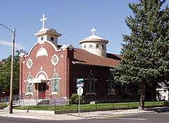 |
(#79000773) |
528 N. 5th Ave. 42°52′12″N 112°26′46″W / 42.87°N 112.446111°W |
Pocatello | |
| 4 | East Side Downtown Historic District | Upload image | (#94001361) |
Roughly including the 200 and 300 blocks of E. Center St., the 100 block of N. 2nd Ave., and the 100 block of S. 2nd Ave. 42°51′43″N 112°26′46″W / 42.861944°N 112.446111°W |
Pocatello | |
| 5 | Fort Hall |  |
(#66000306) |
11 miles west of Fort Hall on the Fort Hall Indian Reservation 43°01′24″N 112°37′58″W / 43.023333°N 112.632778°W |
Fort Hall | Site of the first Fort Hall, 1834-1856 |
| 6 | H.O. Harkness Stable Building | 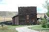 |
(#80001293) |
105 S. Railroad Ave. 42°39′21″N 112°11′33″W / 42.65578°N 112.19241°W |
McCammon | |
| 7 | John Hood House | 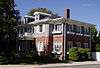 |
(#78001043) |
554 S. 7th Ave. 42°51′58″N 112°26′17″W / 42.866111°N 112.438056°W |
Pocatello | |
| 8 | William A. Hyde House |  |
(#83000259) |
429 N. 7th St. 42°52′10″N 112°26′39″W / 42.869444°N 112.444167°W |
Pocatello | |
| 9 | Idaho State University Administration Building |  |
(#93000994) |
919 S. 8th St., Building 10, on the Idaho State University campus 42°51′43″N 112°25′58″W / 42.861944°N 112.432778°W |
Pocatello | |
| 10 | Idaho State University Neighborhood Historic District | Upload image | (#84001008) |
Roughly bounded by 6th, 9th, Carter, and Center Sts. 42°51′57″N 112°26′15″W / 42.865833°N 112.4375°W |
Pocatello | |
| 11 | L.D.S. Ward Building | Upload image | (#99001474) |
187 S. 2nd Ave. 42°37′04″N 112°00′51″W / 42.617778°N 112.014167°W |
Lava Hot Springs | |
| 12 | Lava High School Gymnasium | Upload image | (#97000764) |
202 W. Fife St. 42°37′00″N 112°00′52″W / 42.616667°N 112.014444°W |
Lava Hot Springs | |
| 13 | Lincoln-Johnson Avenues Residential Historic District | Upload image | (#06000126) |
Roughly bounded by W. Hayden St., the Portneuf River, W. Benton St., and the West Bench 42°51′30″N 112°27′17″W / 42.858333°N 112.454722°W |
Pocatello | |
| 14 | McCammon State Bank Building | 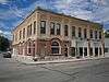 |
(#79000771) |
206 Center St. 42°39′14″N 112°11′40″W / 42.653889°N 112.194444°W |
McCammon | Built in 1906, now the Harkness Hotel |
| 15 | Old Town Residential Historic District | Upload image | (#08000249) |
Roughly bounded by W. Benton, S. Garfield, and W. Lewis Sts., and the Portneuf River 42°51′30″N 112°27′06″W / 42.85832°N 112.45155°W |
Pocatello | |
| 16 | Pocatello Carnegie Library | 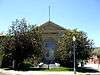 |
(#73000679) |
113 S. Garfield Ave. 42°51′38″N 112°27′08″W / 42.860556°N 112.452222°W |
Pocatello | |
| 17 | Pocatello Federal Building |  |
(#77000452) |
Arthur Ave. and Lewis St. 42°51′40″N 112°27′00″W / 42.861111°N 112.45°W |
Pocatello | |
| 18 | Pocatello Historic District |  |
(#82002505) |
Roughly bounded by railroad tracks and W. Fremont, W. Bonneville, and Garfield Sts. 42°51′44″N 112°27′03″W / 42.862222°N 112.450833°W |
Pocatello | |
| 19 | Pocatello Warehouse Historic District | Upload image | (#96000946) |
Roughly bounded by S. 2nd Ave., E. Halliday, E. Sutter, and the Oregon Short Line railroad tracks 42°51′29″N 112°26′20″W / 42.858056°N 112.438889°W |
Pocatello | |
| 20 | Pocatello Westside Residential Historic District | Upload image | (#03000102) |
Roughly bounded by N. Arthur Ave., W. Fremont St., N. Grant Ave., and W. Young St. 42°51′53″N 112°27′26″W / 42.864722°N 112.457222°W |
Pocatello | |
| 21 | Quinn Apartments | 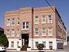 |
(#85000057) |
580 W. Clark St. 42°51′41″N 112°27′12″W / 42.861389°N 112.453333°W |
Pocatello | |
| 22 | Rice-Packard House |  |
(#85002159) |
454 N. Hayes Ave. 42°51′48″N 112°27′21″W / 42.863333°N 112.455833°W |
Pocatello | |
| 23 | Riverside Inn | Upload image | (#79000770) |
255 E. Portneuf St. 42°37′11″N 112°00′33″W / 42.619722°N 112.009028°W |
Lava Hot Springs | |
| 24 | St. Joseph's Catholic Church |  |
(#78001044) |
455 N. Hayes 42°51′46″N 112°27′23″W / 42.862778°N 112.456389°W |
Pocatello | |
| 25 | Standrod House | 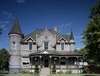 |
(#73000680) |
648 N. Garfield Ave. 42°51′54″N 112°27′27″W / 42.86498°N 112.45744°W |
Pocatello | |
| 26 | Sullivan-Kinney House | 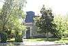 |
(#77000453) |
441 S. Garfield Ave. 42°51′29″N 112°26′55″W / 42.858056°N 112.448611°W |
Pocatello | |
| 27 | Trinity Episcopal Church | 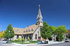 |
(#78001045) |
248 N. Arthur St. 42°51′47″N 112°27′08″W / 42.863056°N 112.452222°W |
Pocatello | |
| 28 | Whitestone Hotel | Upload image | (#80001292) |
2nd Ave. and Main St. 42°37′11″N 112°00′31″W / 42.619722°N 112.008611°W |
Lava Hot Springs | Demolished in 1997 |
| 29 | Woolley Apartments | 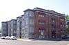 |
(#85003425) |
303 N. Hayes Ave. 42°51′42″N 112°27′18″W / 42.861667°N 112.455°W |
Pocatello |
See also
| Wikimedia Commons has media related to National Register of Historic Places in Bannock County, Idaho. |
References
- ↑ The latitude and longitude information provided in this table was derived originally from the National Register Information System, which has been found to be fairly accurate for about 99% of listings. For about 1% of NRIS original coordinates, experience has shown that one or both coordinates are typos or otherwise extremely far off; some corrections may have been made. A more subtle problem causes many locations to be off by up to 150 yards, depending on location in the country: most NRIS coordinates were derived from tracing out latitude and longitudes off of USGS topographical quadrant maps created under the North American Datum of 1927, which differs from the current, highly accurate WGS84 GPS system used by most on-line maps. Chicago is about right, but NRIS longitudes in Washington are higher by about 4.5 seconds, and are lower by about 2.0 seconds in Maine. Latitudes differ by about 1.0 second in Florida. Some locations in this table may have been corrected to current GPS standards.
- ↑ "National Register of Historic Places: Weekly List Actions". National Park Service. Retrieved March 29, 2009.
- ↑ "National Register of Historic Places: Weekly List Actions". National Park Service, United States Department of the Interior. Retrieved on December 16, 2016.
- ↑ Numbers represent an ordering by significant words. Various colorings, defined here, differentiate National Historic Landmarks and historic districts from other NRHP buildings, structures, sites or objects.
- ↑ National Park Service (2008-04-24). "National Register Information System". National Register of Historic Places. National Park Service.
- ↑ The eight-digit number below each date is the number assigned to each location in the National Register Information System database, which can be viewed by clicking the number.

| Topics | |
|---|---|
| Lists by states |
|
| Lists by insular areas | |
| Lists by associated states | |
| Other areas | |
| |
Municipalities and communities of Bannock County, Idaho, United States | ||
|---|---|---|
| Cities | ||
| CDPs | ||
| Unincorporated community | ||
| Indian reservation | ||
This article is issued from Wikipedia - version of the 10/7/2016. The text is available under the Creative Commons Attribution/Share Alike but additional terms may apply for the media files.