Celebration Park


Celebration Park is an archaeological park in the western United States, located in southwestern Idaho. It is the state's first archeological park and is adjacent to the Snake River near Melba and Walter's Ferry in Canyon County.[1]
It features camping, restrooms, drinking water, picnicking, self-guided tours and interpretive programs as well as fishing and access to hiking trails and the Snake River with a small day use fee. The elevation of the river at the park is approximately 2,250 feet (690 m) above sea level.
History
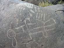
This park features in-situ petroglyphs- rock carvings made by Native Americans dating from historical times to more than 12,000 years ago.[2] During the winter, the Paiute lived at lower elevations along the Snake River [3] like at this site, and this region was also home to Shoshone. A fresh water spring in the park area made it an ideal camping spot for many generations.
The park's Guffey railroad bridge over the Snake River was built 119 years ago in 1897, to carry gold and silver ore from Silver City in the Owyhee mountains to Nampa for smelting.[2] It has been refurbished and is open for walking and horseback riding.[4] It is the only Parker-Through-Truss railroad bridge in Idaho and is the state's largest historic artifact; it was entered into the National Register of Historic Places in 1978. The 450-ton steel structure is 70 feet (21 m) tall and spans 500 feet (150 m) over the river. The bridge was abandoned 69 years ago in 1947, saved from demolition in the 1970s, and purchased and restored by Canyon County in 1989.[5]
A walk to Halverson Lake will take you past the crumbling walls of remote basalt cabin of one of the earliest African-American people to live in the area.

Video
- You Tube - Guffey Bridge, Snake River, Idaho
References
- ↑ "Celebration Park" (PDF). Oregon-California Trails Association. (Idaho Chapter). 2008. Retrieved January 27, 2016.
- 1 2 "Celebration Park". US Dept. of the Interior, BLM. Retrieved 2 May 2014.
- ↑ "Celebration Park". Visit Idaho.org. Retrieved 2 May 2014.
- ↑ "Guffey Railroad Bridge Trail". Trail Link. Retrieved January 27, 2016.
- ↑ "Historic Guffey Bridge". Idaho Heritage. Retrieved January 27, 2016.
External links
- Canyon County Idaho- Celebration Park including maps of hiking trails.
- Every Trail- Halverson Lake Loop Trail includes maps and pictures that you can add to.
Coordinates: 43°17′56″N 116°31′23″W / 43.299°N 116.523°W