National Register of Historic Places listings in Ashland County, Ohio
Location of Ashland County in Ohio
This is a list of the National Register of Historic Places listings in Ashland County, Ohio.
This is intended to be a complete list of the properties and districts on the National Register of Historic Places in Ashland County, Ohio, United States. The locations of National Register properties and districts for which the latitude and longitude coordinates are included below, may be seen in a Google map.[1]
There are 16 properties and districts listed on the National Register in the county. Another 2 properties were once listed but have been removed.
- This National Park Service list is complete through NPS recent listings posted December 2, 2016.[2]
Current listings
| [3] | Name on the Register[4] | Image | Date listed[5] | Location | City or town | Description |
|---|---|---|---|---|---|---|
| 1 | Anderson Schoolhouse |  |
(#77001040) |
Southwest of Ashland on U.S. Route 42 40°50′30″N 82°21′32″W / 40.841667°N 82.358889°W |
Milton Township | |
| 2 | Ashland County Courthouse | 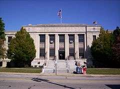 |
(#79003786) |
W. 2nd St. 40°52′10″N 82°19′03″W / 40.869444°N 82.3175°W |
Ashland | |
| 3 | Philip J. Black House | 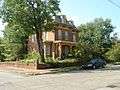 |
(#80002935) |
303 N. Water St. 40°38′18″N 82°14′07″W / 40.638333°N 82.235278°W |
Loudonville | |
| 4 | T.J. and Sarah Bull House | 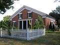 |
(#07000302) |
109 S. Market St. 40°38′06″N 82°14′00″W / 40.635125°N 82.233438°W |
Loudonville | |
| 5 | Center Street Historic District | 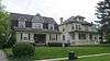 |
(#76001362) |
Center St. from Vernon to 414 Center St.; also Center St. between Town Creek and Walnut St. and between Samaritan and Morgan Aves. 40°51′46″N 82°18′45″W / 40.862868°N 82.312381°W |
Ashland | Second set of boundaries represents a boundary increase of May 6, 1993 |
| 6 | City Hall and Opera House | 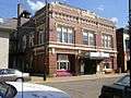 |
(#96001618) |
156 N. Water St. 40°38′11″N 82°14′05″W / 40.636389°N 82.234722°W |
Loudonville | |
| 7 | Crittenden Farm | 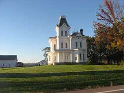 |
(#82003540) |
Northwest of Savannah on U.S. Routes 224 and 250 41°01′43″N 82°25′37″W / 41.028611°N 82.426944°W |
Ruggles Township | |
| 8 | John Crumrine Farm | 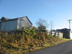 |
(#90001778) |
792 County Road 40 north of Nova 41°03′29″N 82°16′50″W / 41.058056°N 82.280556°W |
Troy Township | |
| 9 | Michael Crumrine Farm |  |
(#90001779) |
871 County Road 40 north of Nova 41°03′27″N 82°17′42″W / 41.057500°N 82.295000°W |
Troy Township | |
| 10 | Downtown Ashland Historic District | 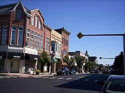 |
(#12001209) |
Roughly bounded by Cottage-Claremont Ave., 3rd, 4th, and Union Sts., and Town Creek 40°52′08″N 82°18′56″W / 40.868889°N 82.315556°W |
Ashland | |
| 11 | John Garst House | 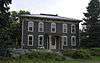 |
(#82003539) |
Northeast of Loudonville on State Route 95 40°43′40″N 82°11′52″W / 40.727778°N 82.197778°W |
Mohican Township | |
| 12 | Hayesville Opera House | 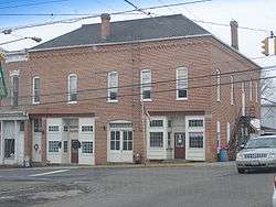 |
(#76001364) |
1 E. Main St. 40°46′23″N 82°15′42″W / 40.773056°N 82.261667°W |
Hayesville | |
| 13 | Lakefork School | 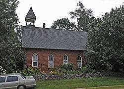 |
(#82003538) |
Southeast of Jeromesville 40°45′17″N 82°08′47″W / 40.754722°N 82.146389°W |
Mohican Township | |
| 14 | Myers Block-Home Company Building | 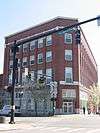 |
(#96001620) |
1 E. Main St. 40°52′06″N 82°18′53″W / 40.868333°N 82.314722°W |
Ashland | |
| 15 | Sprott's Hill Mounds Site | 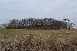 |
(#76001363) |
Western side of Township Road 1193 between Bailey Lake and Ashland[6] 40°54′49″N 82°21′42″W / 40.913611°N 82.361667°W |
Clear Creek Township | Two mounds, located on Sprott's Hill[7] |
| 16 | Vermilion Institute | 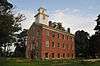 |
(#78002000) |
Main and College Sts. 40°46′26″N 82°15′20″W / 40.773889°N 82.255556°W |
Hayesville |
Former listings
| [3] | Name on the Register | Image | Date listed | Date removed | Location | City or town | Summary |
|---|---|---|---|---|---|---|---|
| 1 | Ashland County Jail | Upload image | (#76001361) | W. 2nd and Cottage Streets 40°52′10″N 82°19′05″W / 40.8695°N 82.318°W |
Ashland | ||
| 2 | First National Bank and Firestone Building | Upload image | (#76002288) | 2-10 W. Main Street 40°52′08″N 82°18′55″W / 40.8688°N 82.3152°W |
Ashland |
See also
| Wikimedia Commons has media related to National Register of Historic Places in Ashland County, Ohio. |
References
- ↑ The latitude and longitude information provided in this table was derived originally from the National Register Information System, which has been found to be fairly accurate for about 99% of listings. For about 1% of NRIS original coordinates, experience has shown that one or both coordinates are typos or otherwise extremely far off; some corrections may have been made. A more subtle problem causes many locations to be off by up to 150 yards, depending on location in the country: most NRIS coordinates were derived from tracing out latitude and longitudes off of USGS topographical quadrant maps created under the North American Datum of 1927, which differs from the current, highly accurate WGS84 GPS system used by most on-line maps. Chicago is about right, but NRIS longitudes in Washington are higher by about 4.5 seconds, and are lower by about 2.0 seconds in Maine. Latitudes differ by about 1.0 second in Florida. Some locations in this table may have been corrected to current GPS standards.
- ↑ "National Register of Historic Places: Weekly List Actions". National Park Service, United States Department of the Interior. Retrieved on December 2, 2016.
- 1 2 Numbers represent an ordering by significant words. Various colorings, defined here, differentiate National Historic Landmarks and historic districts from other NRHP buildings, structures, sites or objects.
- ↑ National Park Service (2008-04-24). "National Register Information System". National Register of Historic Places. National Park Service.
- ↑ The eight-digit number below each date is the number assigned to each location in the National Register Information System database, which can be viewed by clicking the number.
- ↑ Location derived from the GNIS feature record for Sprott's Hill, on which the mounds are located; the NRIS lists the site as "Address Restricted".
- ↑ Thomas, Mrs. Cyrus. Bibliography of the Earthworks of Ohio. Washington: Smithsonian Institution, 1888. Accessed 2009-07-22.


Municipalities and communities of Ashland County, Ohio, United States | ||
|---|---|---|
| City | | |
| Villages | ||
| Townships | ||
| CDP | ||
| Unincorporated communities | ||
| Footnotes | ‡This populated place also has portions in an adjacent county or counties | |
This article is issued from Wikipedia - version of the 1/17/2016. The text is available under the Creative Commons Attribution/Share Alike but additional terms may apply for the media files.