National Register of Historic Places listings in Apache County, Arizona
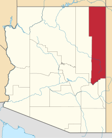
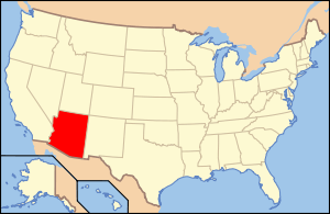
Location of Apache County in Arizona
This is a list of the National Register of Historic Places listings in Apache County, Arizona. It is intended to be a complete list of the properties and districts on the National Register of Historic Places in Apache County, Arizona, United States. The locations of National Register properties and districts for which the latitude and longitude coordinates are included below, may be seen in a map.[1]
There are 32 properties and districts listed on the National Register in the county, including 5 that are also National Historic Landmarks.
- This National Park Service list is complete through NPS recent listings posted December 16, 2016.[2]
Listings county-wide
| [3] | Name on the Register | Image | Date listed[4] | Location | City or town | Description |
|---|---|---|---|---|---|---|
| 1 | Allentown Bridge | 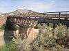 |
(#88001617) |
Indian Route 9402 over the Puerco River at milepost 9.1 35°16′51″N 109°09′16″W / 35.280833°N 109.154444°W |
Houck | |
| 2 | Alpine Elementary School | Upload image | (#97000369) |
11 and 12 County Road 2052, near its junction with U.S. Route 180 33°50′51″N 109°08′27″W / 33.8475°N 109.140833°W |
Alpine | |
| 3 | Butterfly Lodge | Upload image | (#92000686) |
Forest Rd. 245 east of State Route 373 in the Apache National Forest 34°01′08″N 109°26′57″W / 34.018889°N 109.449167°W |
Greer | |
| 4 | Canyon de Chelly National Monument | 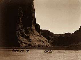 |
(#70000066) |
Eastern side of Chinle 36°08′21″N 109°20′05″W / 36.139167°N 109.334722°W |
Chinle | |
| 5 | Casa Malpais Site | 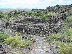 |
(#66000936) |
Address restricted 34°09′33″N 109°17′24″W / 34.159167°N 109.29°W |
Springerville | |
| 6 | Chinle Franciscan Mission Historic District | Upload image | (#07000506) |
Indian Service Route 7 across road and southwest of the Chinle Judicial complex and Police Station Coordinates missing |
Chinle | |
| 7 | Colter Ranch Historic District | Upload image | (#93000626) |
Junction of 4th St. and School Bus Rd. 34°06′24″N 109°19′11″W / 34.106667°N 109.319722°W |
Eagar | |
| 8 | Eagar School | 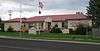 |
(#93000624) |
174 S. Main St. 34°06′29″N 109°17′31″W / 34.107918°N 109.292079°W |
Eagar | Now the Eagar police station.[5] |
| 9 | Eagar Townsite Historic District | 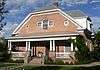 |
(#93000625) |
Roughly bounded by Central Ave., Main St., 1st Ave. and Eagar St. 2nd Ave, and Harless St., 3rd Ave., and Eagar St. 34°06′45″N 109°17′25″W / 34.1125°N 109.290278°W |
Eagar | |
| 10 | Flattop Site | Upload image | (#76000214) |
Address restricted |
Adamana | |
| 11 | Hubbell Trading Post National Historic Site | 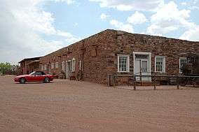 |
(#66000167) |
Western side of Ganado Coordinates missing |
Ganado | |
| 12 | Isaacson Building | Upload image | (#83002997) |
37 Commercial St. 34°30′22″N 109°21′47″W / 34.506111°N 109.363056°W |
St. Johns | |
| 13 | Kin Tiel | Upload image | (#78000540) |
Address restricted |
Chambers | |
| 14 | Lake Mountain Lookout Complex | Upload image | (#87002453) |
Off Vernon McNary Rd. 34°09′28″N 109°46′07″W / 34.157778°N 109.768611°W |
McNary | |
| 15 | Los Burros Ranger Station | Upload image | (#86002854) |
Forest Rd. 20 34°08′27″N 109°45′55″W / 34.140833°N 109.765278°W |
McNary | |
| 16 | Lower Zuni River Archeological District | Upload image | (#94000398) |
Address restricted |
St. Johns | |
| 17 | Lyman Lake Rock Art Site | Upload image | (#97000347) |
Address restricted |
St. Johns | |
| 18 | Navajo Nation Council Chamber | 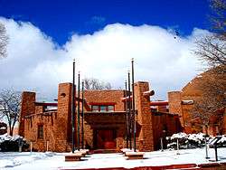 |
(#04001155) |
W008-013 Circle Boulevard 35°40′58″N 109°02′54″W / 35.682778°N 109.048333°W |
Window Rock | |
| 19 | Newspaper Rock Petroglyphs Archeological District | 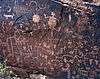 |
(#76000185) |
Address restricted 34°57′43″N 109°47′57″W / 34.962066°N 109.799059°W |
Adamana | |
| 20 | Painted Desert Community Complex Historic District | 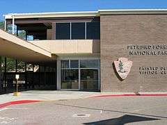 |
(#05000284) |
One Park Rd. 35°04′06″N 109°46′50″W / 35.068333°N 109.780556°W |
Petrified Forest National Park | |
| 21 | Painted Desert Inn | 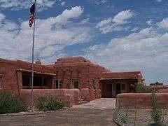 |
(#87001421) |
West of Navajo in Petrified Forest National Park, off Interstate 40 35°05′03″N 109°47′06″W / 35.084167°N 109.785°W |
Navajo | Designated a National Historic Landmark on May 28, 1987 |
| 22 | PS Knoll Lookout Complex | Upload image | (#87002451) |
Apache-Sitgreaves National Forest 33°45′16″N 109°23′52″W / 33.754444°N 109.397778°W |
Maverick | |
| 23 | Puerco Ruin and Petroglyphs | 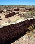 |
(#76000208) |
Address restricted 34°58′29″N 109°47′39″W / 34.974823°N 109.794089°W |
Adamana | |
| 24 | Querino Canyon Bridge | Upload image | (#88001623) |
Old U.S. Route 66 over Querino Canyon 35°16′49″N 109°15′28″W / 35.280278°N 109.257778°W |
Houck | |
| 25 | Rattlesnake Point Pueblo | Upload image | (#01000792) |
Lyman Lake State Park Coordinates missing |
St. Johns | |
| 26 | Sage Memorial Hospital School of Nursing | Upload image | (#09000082) |
Ganado Mission Coordinates missing |
Ganado | |
| 27 | St. Michael's Mission |  |
(#75000335) |
North of Window Rock off State Route 264 35°38′44″N 109°05′53″W / 35.645556°N 109.098056°W |
Window Rock | |
| 28 | Sanders Bridge | Upload image | (#88001618) |
Indian Route 9402 over the Puerco River 35°12′46″N 109°19′47″W / 35.212778°N 109.329722°W |
Sanders | |
| 29 | Sherwood Ranch Pueblo | Upload image | (#05000887) |
Address restricted |
Springerville | |
| 30 | Thirty-Fifth Parallel Route | Upload image | (#77000129) |
25 miles east of Holbrook off Interstate 40 35°04′09″N 109°46′14″W / 35.069167°N 109.770556°W |
Holbrook | |
| 31 | Twin Buttes Archeological District | Upload image | (#76000952) |
Address restricted |
Adamana | |
| 32 | Water Canyon Administrative Site | Upload image | (#93000511) |
Forest Rd. 285 south of Springerville, Apache-Sitgreaves National Forest 34°03′56″N 109°17′34″W / 34.065556°N 109.292778°W |
Springerville |
Former listings
| [3] | Name on the Register | Image | Date listed | Date removed | Location | City or town | Summary |
|---|---|---|---|---|---|---|---|
| 1 | Barth Hotel | Upload image | (#75000334) | 187 E. Commercial St. |
St. Johns | ||
| 2 | Petrified Forest Bridge | Upload image | (#88001616) | Petrified Forest Park Rd. over Rio Puerco |
Navajo vicinity | Vehicular Bridges in Arizona MPS |
See also
| Wikimedia Commons has media related to National Register of Historic Places in Apache County, Arizona. |
- List of National Historic Landmarks in Arizona
- National Register of Historic Places listings in Arizona
References
- ↑ The latitude and longitude information provided in this table was derived originally from the National Register Information System, which has been found to be fairly accurate for about 99% of listings. For about 1% of NRIS original coordinates, experience has shown that one or both coordinates are typos or otherwise extremely far off; some corrections may have been made. A more subtle problem causes many locations to be off by up to 150 yards, depending on location in the country: most NRIS coordinates were derived from tracing out latitude and longitudes off of USGS topographical quadrant maps created under the North American Datum of 1927, which differs from the current, highly accurate WGS84 GPS system used by most on-line maps. Chicago is about right, but NRIS longitudes in Washington are higher by about 4.5 seconds, and are lower by about 2.0 seconds in Maine. Latitudes differ by about 1.0 second in Florida. Some locations in this table may have been corrected to current GPS standards.
- ↑ "National Register of Historic Places: Weekly List Actions". National Park Service, United States Department of the Interior. Retrieved on December 16, 2016.
- 1 2 Numbers represent an ordering by significant words. Various colorings, defined here, differentiate National Historic Landmarks and historic districts from other NRHP buildings, structures, sites or objects.
- ↑ The eight-digit number below each date is the number assigned to each location in the National Register Information System database, which can be viewed by clicking the number.
- ↑ "Eagar Police Department". Retrieved 2013-09-18.
- ↑ http://www.nps.gov/history/nr/listings/Weekly_Register_List_1985.pdf NRHP 1985 Weekly listings
 |  | ||
Municipalities and communities of Apache County, Arizona, United States | ||
|---|---|---|
| City | | |
| Towns | ||
| CDPs |
| |
| Unincorporated communities |
| |
| Indian reservations | ||
| Footnotes | ‡This populated place also has portions in an adjacent county or counties | |
| Topics | |
|---|---|
| Lists by states |
|
| Lists by insular areas | |
| Lists by associated states | |
| Other areas | |
| |
This article is issued from Wikipedia - version of the 4/19/2016. The text is available under the Creative Commons Attribution/Share Alike but additional terms may apply for the media files.