Hunt, Arizona
| Hunt, Arizona | |
|---|---|
| Populated place | |
 Hunt  Hunt Location within the state of Arizona | |
| Coordinates: 34°36′36″N 109°37′39″W / 34.61000°N 109.62750°WCoordinates: 34°36′36″N 109°37′39″W / 34.61000°N 109.62750°W | |
| Country | United States |
| State | Arizona |
| County | Apache |
| Elevation[1] | 5,433 ft (1,656 m) |
| Time zone | Mountain (MST) (UTC-7) |
| • Summer (DST) | MST (UTC-7) |
| Area code(s) | 928 |
| FIPS code | 04-34680 |
| GNIS feature ID | 24468 |
Hunt is a populated place situated on the Little Colorado River at the mouth of Concho Creek in Apache County, Arizona.[2] It is named after Colonel James Hunt, who served at Fort Apache in the 1870s.[3] It has an estimated elevation of 5,433 feet (1,656 m) above sea level.[1]
References
- 1 2 "Feature Detail Report for: Hunt". Geographic Names Information System. United States Geological Survey.
- ↑ "Hunt (in Apache County, AZ) Populated Place Profile". AZ Hometown Locator. Retrieved November 28, 2016.
- ↑ Barnes, Will Croft (2016). Arizona Place Names. Tucson: Arizona Place Names. p. 217. ISBN 0816534950.
Municipalities and communities of Apache County, Arizona, United States | ||
|---|---|---|
| City | 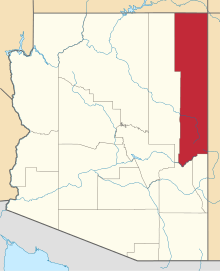 | |
| Towns | ||
| CDPs |
| |
| Unincorporated communities |
| |
| Indian reservations | ||
| Footnotes | ‡This populated place also has portions in an adjacent county or counties | |
This article is issued from Wikipedia - version of the 11/28/2016. The text is available under the Creative Commons Attribution/Share Alike but additional terms may apply for the media files.